
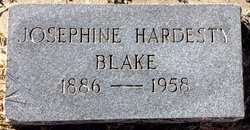
Martha Josephine Hardesty Blake
| Birth | : | 27 Feb 1886 Delphos, Ottawa County, Kansas, USA |
| Death | : | 19 Feb 1958 Concordia, Cloud County, Kansas, USA |
| Burial | : | Glasco Cemetery, Glasco, Cloud County, USA |
| Coordinate | : | 39.3574000, -97.8265000 |
| Plot | : | 86W28 |
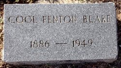
| Description | : | Glasco Sun, February 27, 1958, page 1: Rites Held Saturday For Josephine Blake Josephine Hardesty Blake was born to William and Bella Hardesty, Cloud county pioneers, at Delphos, February 27, 1886, and departed this life February 19, 1958, at the St. Joseph's hospital in Concordia. She would have been 72 years of age the 27th of this month. From the time of her marriage to Cool F. Blake, November 18, 1908, she resided at the Blake family home east of Glasco. She is survived by a brother, Otis Hardesty of Minneapolis; a sister, Mrs. Mildred Davis of Concordia; four sons, Fenton W. of... Read More |
frequently asked questions (FAQ):
-
Where is Martha Josephine Hardesty Blake's memorial?
Martha Josephine Hardesty Blake's memorial is located at: Glasco Cemetery, Glasco, Cloud County, USA.
-
When did Martha Josephine Hardesty Blake death?
Martha Josephine Hardesty Blake death on 19 Feb 1958 in Concordia, Cloud County, Kansas, USA
-
Where are the coordinates of the Martha Josephine Hardesty Blake's memorial?
Latitude: 39.3574000
Longitude: -97.8265000
Family Members:
Parent
Spouse
Siblings
Children

Flowers:


Nearby Cemetories:
1. Glasco Cemetery
Glasco, Cloud County, USA
Coordinate: 39.3574000, -97.8265000
2. Saint Marys Catholic Cemetery
Glasco, Cloud County, USA
Coordinate: 39.3574000, -97.8245000
3. Simpson Cemetery
Simpson, Mitchell County, USA
Coordinate: 39.3633003, -97.9471970
4. Bethel Cemetery
Meredith Township, Cloud County, USA
Coordinate: 39.3506000, -97.7029000
5. Delphos Cemetery
Delphos, Ottawa County, USA
Coordinate: 39.2778015, -97.7416992
6. Saint Paul Cemetery
Delphos, Ottawa County, USA
Coordinate: 39.2677994, -97.7518997
7. Asherville Cemetery
Asherville, Mitchell County, USA
Coordinate: 39.4205000, -97.9672900
8. Morrison Cemetery
Center Township, Cloud County, USA
Coordinate: 39.4817009, -97.7975006
9. Summit Cemetery
Jamestown, Cloud County, USA
Coordinate: 39.4813200, -97.8628800
10. Green Mound Cemetery
Asherville, Mitchell County, USA
Coordinate: 39.3203011, -97.9858017
11. Coursen Grove Cemetery
Simpson, Mitchell County, USA
Coordinate: 39.3060989, -97.9792023
12. Hall Cemetery
Cloud County, USA
Coordinate: 39.4455986, -97.7033005
13. Saint Peters Cemetery
Miltonvale, Cloud County, USA
Coordinate: 39.3652350, -97.6483570
14. Bell-Bogardus Cemetery
Asherville, Mitchell County, USA
Coordinate: 39.4242410, -97.9919970
15. Bohemian National Cemetery
Ada, Ottawa County, USA
Coordinate: 39.2193870, -97.9054030
16. Wilcox Cemetery
Cloud County, USA
Coordinate: 39.4925003, -97.7313995
17. West Asher Cemetery
Scottsville, Mitchell County, USA
Coordinate: 39.4815000, -97.9661600
18. Baldwin Cemetery
Ottawa County, USA
Coordinate: 39.2061005, -97.9111023
19. Kindel Cemetery
Center Township, Cloud County, USA
Coordinate: 39.4519005, -97.6464005
20. Smith Cemetery
Asherville, Mitchell County, USA
Coordinate: 39.4516690, -98.0098850
21. McBride Cemetery
Beloit, Mitchell County, USA
Coordinate: 39.4808006, -97.9907990
22. Enterprise Cemetery
Cloud County, USA
Coordinate: 39.4230995, -97.6106033
23. Shiloh Cemetery
Beloit, Mitchell County, USA
Coordinate: 39.3574982, -98.0594025
24. Summit Cemetery #3
Macyville, Cloud County, USA
Coordinate: 39.5258330, -97.9194440