
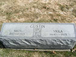
Martha Viola Davis Gustin
| Birth | : | 23 Dec 1864 Springfield, Lane County, Oregon, USA |
| Death | : | 15 Jan 1925 Pomeroy, Garfield County, Washington, USA |
| Burial | : | Chelan Fraternal Cemetery, Chelan, Chelan County, USA |
| Coordinate | : | 47.8502998, -120.0081024 |
| Plot | : | South Fraternal Row5 BLK7 LS4 |
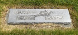
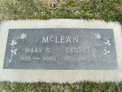
| Inscription | : | Amos Gustin |
| Description | : | Mrs. Martha Viola Davis Gustin, mother of Mrs. McLean of Beebe, was born December 23, 1864, at Springfield, Oregon and died at Pomeroy, Wa., January 15, 1925 being 60 years of age. Her husband preceded her about eighteen months ago. There are twelve children who more her loss. Mrs. Gustin was a member of the Latter Day Saints church. Funeral services were held on Sunday afternoon at the Methodist Church, the Rev. H. Attenborough officiating. Interment was made in the local cemetery. Washington Death Certificate Name Martha Viola Gustin Death date 15 Jan 1925 |
frequently asked questions (FAQ):
-
Where is Martha Viola Davis Gustin's memorial?
Martha Viola Davis Gustin's memorial is located at: Chelan Fraternal Cemetery, Chelan, Chelan County, USA.
-
When did Martha Viola Davis Gustin death?
Martha Viola Davis Gustin death on 15 Jan 1925 in Pomeroy, Garfield County, Washington, USA
-
Where are the coordinates of the Martha Viola Davis Gustin's memorial?
Latitude: 47.8502998
Longitude: -120.0081024
Family Members:
Parent

Spouse

Siblings
Children
Flowers:


Nearby Cemetories:
1. Chelan Fraternal Cemetery
Chelan, Chelan County, USA
Coordinate: 47.8502998, -120.0081024
2. Mount Olivet Cemetery
Chelan, Chelan County, USA
Coordinate: 47.8451000, -119.9946000
3. Saint Andrews Episcopal Church
Chelan, Chelan County, USA
Coordinate: 47.8397460, -120.0183780
4. Riverview Cemetery
Chelan, Chelan County, USA
Coordinate: 47.8335991, -119.9944000
5. Manson Indian Cemetery
Manson, Chelan County, USA
Coordinate: 47.8800000, -120.1300000
6. Ballard Family Cemetery
Stayman, Chelan County, USA
Coordinate: 47.7811100, -120.1133300
7. Fletcher Cemetery
Douglas County, USA
Coordinate: 47.7430992, -119.9403000
8. Brays Landing Cemetery
Douglas County, USA
Coordinate: 47.7364120, -120.1704660
9. Kummer Cemetery
Waterville, Douglas County, USA
Coordinate: 47.6559000, -120.0332000
10. Packwood Memorial Cemetery
Dyer, Douglas County, USA
Coordinate: 48.0118305, -119.8178880
11. Dick Family Cemetery
Okanogan County, USA
Coordinate: 48.0502700, -119.9241700
12. Miller Family Cemetery
Okanogan County, USA
Coordinate: 48.0530300, -119.9288000
13. Pateros Cemetery
Pateros, Okanogan County, USA
Coordinate: 48.0516600, -119.9097300
14. Waterville Cemetery
Waterville, Douglas County, USA
Coordinate: 47.6418500, -120.0685940
15. Gate of Heaven Catholic Cemetery
Waterville, Douglas County, USA
Coordinate: 47.6382100, -120.0671690
16. Douglas Lutheran Cemetery
Douglas County, USA
Coordinate: 47.6189003, -119.9614029
17. Badger Mountain View Cemetery
Douglas County, USA
Coordinate: 47.6088000, -120.0476000
18. Mansfield Cemetery
Mansfield, Douglas County, USA
Coordinate: 47.8088880, -119.6508330
19. Orondo Community Cemetery
Orondo, Douglas County, USA
Coordinate: 47.6486015, -120.2136002
20. Buckingham Cemetery
Douglas County, USA
Coordinate: 47.8669014, -119.6286011
21. Happy Home Cemetery
Farmer, Douglas County, USA
Coordinate: 47.6268997, -119.8125000
22. Methow Cemetery
Methow, Okanogan County, USA
Coordinate: 48.1102982, -120.0124969
23. Entiat Cemetery
Entiat, Chelan County, USA
Coordinate: 47.6755981, -120.3043976
24. Bridgeport Cemetery
Bridgeport, Douglas County, USA
Coordinate: 48.0050000, -119.6738800