
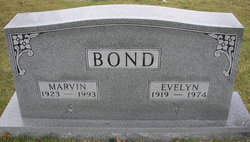
Marvin B. Bond
| Birth | : | 30 Jul 1923 Miller County, Missouri, USA |
| Death | : | 15 Dec 1993 Eldon, Miller County, Missouri, USA |
| Burial | : | Christ Church Churchyard, Accrington, Hyndburn Borough, England |
| Coordinate | : | 53.7478560, -2.3605820 |
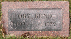
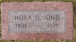
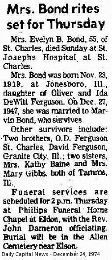
| Description | : | Marvin was born July 30, 1923, in Miller County, a son of Oby B. BOND and Nora Dell SELIX Bond. He was married in 1947 to Evelyne FURGESON Bond, who preceded him in death. He was married June 12, 1976, in Edwards, to Rose Mary ROLFES Ellis Bond. He was a truck driver and lived in St. Louis until his retirement in 1980. He was a member of the Teamsters Union, the Masonic Lodge, the Shriners, the Allen Cemetery Board and the First Baptist Church, Eldon. Headstone has Masons emblem on it. "A.F. & A..M." Ancient Free & Accepted Masons. |
frequently asked questions (FAQ):
-
Where is Marvin B. Bond's memorial?
Marvin B. Bond's memorial is located at: Christ Church Churchyard, Accrington, Hyndburn Borough, England.
-
When did Marvin B. Bond death?
Marvin B. Bond death on 15 Dec 1993 in Eldon, Miller County, Missouri, USA
-
Where are the coordinates of the Marvin B. Bond's memorial?
Latitude: 53.7478560
Longitude: -2.3605820
Family Members:
Parent
Spouse
Siblings


Nearby Cemetories:
1. Christ Church Churchyard
Accrington, Hyndburn Borough, England
Coordinate: 53.7478560, -2.3605820
2. St. James' Parish Church
Accrington, Hyndburn Borough, England
Coordinate: 53.7519900, -2.3652600
3. St. John the Baptist Churchyard
Baxenden, Hyndburn Borough, England
Coordinate: 53.7346500, -2.3470230
4. Accrington Cemetery and Crematorium
Accrington, Hyndburn Borough, England
Coordinate: 53.7623787, -2.3508649
5. Church and Clayton-le-Moors Cemetery
Accrington, Hyndburn Borough, England
Coordinate: 53.7630200, -2.3804820
6. St James Churchyard
Church, Hyndburn Borough, England
Coordinate: 53.7574640, -2.3942660
7. New Lane Baptist Chapel Chapelyard
Oswaldwistle, Hyndburn Borough, England
Coordinate: 53.7381100, -2.4049500
8. Immanuel Churchyard
Oswaldwistle, Hyndburn Borough, England
Coordinate: 53.7358300, -2.4056200
9. Barnes Square Weslyan Methodist Churchyard
Clayton-le-Moors, Hyndburn Borough, England
Coordinate: 53.7744350, -2.3853800
10. All Saints Churchyard
Clayton-le-Moors, Hyndburn Borough, England
Coordinate: 53.7738520, -2.3881690
11. St Marys Burial Ground
Clayton-le-Moors, Hyndburn Borough, England
Coordinate: 53.7792778, -2.3705871
12. St Margaret Churchyard
Hapton, Burnley Borough, England
Coordinate: 53.7802400, -2.3169230
13. Rehoboth Chapel
Goodshaw, Rossendale Borough, England
Coordinate: 53.7355870, -2.2914730
14. Great Harwood Cemetery
Great Harwood, Hyndburn Borough, England
Coordinate: 53.7796190, -2.4091680
15. Our Lady and Saint Hubert
Great Harwood, Hyndburn Borough, England
Coordinate: 53.7851070, -2.4009760
16. St James Churchyard
Haslingden, Rossendale Borough, England
Coordinate: 53.7084000, -2.3259550
17. St James Church
Altham, Hyndburn Borough, England
Coordinate: 53.7928940, -2.3465250
18. Providence Free United Methodist Graveyard
Crawshawbooth, Rossendale Borough, England
Coordinate: 53.7442070, -2.2825700
19. King Street Methodist Chapel Chapelyard
Haslingden, Rossendale Borough, England
Coordinate: 53.7066710, -2.3231330
20. Haslingden Grane Methodist Chapel Cemetery
Haslingden, Rossendale Borough, England
Coordinate: 53.7016300, -2.3728190
21. Ebenezer Baptist Chapel Chapelyard
Haslingden, Rossendale Borough, England
Coordinate: 53.7053960, -2.3230070
22. St. Mary and All Saints Churchyard
Goodshaw, Rossendale Borough, England
Coordinate: 53.7315270, -2.2828940
23. Crawshawbooth Quaker Burial Ground
Crawshawbooth, Rossendale Borough, England
Coordinate: 53.7242420, -2.2879400
24. Goodshaw Particular Baptist Chapel Graveyard
Goodshaw, Rossendale Borough, England
Coordinate: 53.7328210, -2.2815530