

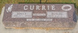
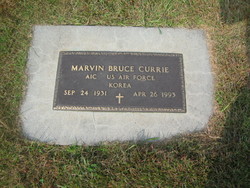
Marvin Bruce Currie
| Birth | : | 24 Sep 1931 Schaller, Sac County, Iowa, USA |
| Death | : | 26 Apr 1993 Sioux City, Woodbury County, Iowa, USA |
| Burial | : | Otahuhu Public Cemetery, Ōtāhūhū, Auckland Council, New Zealand |
| Coordinate | : | -36.9377500, 174.8432390 |
| Plot | : | 911 |
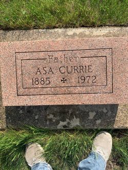
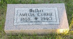
| Description | : | Funeral services for Marvin Bruce Currie, 61, of Schaller were Thursday, April 29,1993, at the First Presbyterian Church in Schaller with Pastor Ken Fells officiating. Burial was in the Schaller Cemetery, Schaller. Pallbearers were John Zulfer, Jim Zulfer, Mark Currie, Scott Currie, Craig Currie and David Radke. Honorary pallbearers were Don Crawford, Tom Watson, Mark Wandrey and Dean Schaefer. Marvin Bruce Currie was born Sept. 24, 1931 in Schaller to Asa and Amelia Jensen Currie. He was confirmed at a young age. Marvin attended high school in Schaller and then graduated from Commercial Extension Business College in Omaha, Neb. He... Read More |
frequently asked questions (FAQ):
-
Where is Marvin Bruce Currie's memorial?
Marvin Bruce Currie's memorial is located at: Otahuhu Public Cemetery, Ōtāhūhū, Auckland Council, New Zealand.
-
When did Marvin Bruce Currie death?
Marvin Bruce Currie death on 26 Apr 1993 in Sioux City, Woodbury County, Iowa, USA
-
Where are the coordinates of the Marvin Bruce Currie's memorial?
Latitude: -36.9377500
Longitude: 174.8432390
Family Members:
Parent
Siblings


Flowers:


Nearby Cemetories:
1. Otahuhu Public Cemetery
Ōtāhūhū, Auckland Council, New Zealand
Coordinate: -36.9377500, 174.8432390
2. Holy Trinity Memorial Park
Ōtāhūhū, Auckland Council, New Zealand
Coordinate: -36.9374510, 174.8448580
3. St. Joseph and St. Joachim Catholic Cemetery
Ōtāhūhū, Auckland Council, New Zealand
Coordinate: -36.9436100, 174.8490100
4. Nixon Memorial
Ōtāhūhū, Auckland Council, New Zealand
Coordinate: -36.9499366, 174.8449909
5. St. John's Presbyterian Church Cemetery
Papatoetoe, Auckland Council, New Zealand
Coordinate: -36.9674185, 174.8598178
6. St Matthias Churchyard
Panmure, Auckland Council, New Zealand
Coordinate: -36.9053300, 174.8577200
7. St. Patrick's Roman Catholic Church Cemetery
Panmure, Auckland Council, New Zealand
Coordinate: -36.9029680, 174.8564960
8. Waikaraka Cemetery
Ōnehunga, Auckland Council, New Zealand
Coordinate: -36.9297140, 174.7967170
9. St. John's Church Cemetery
East Tamaki, Auckland Council, New Zealand
Coordinate: -36.9522250, 174.8964540
10. Onehunga Catholic Cemetery
Ōnehunga, Auckland Council, New Zealand
Coordinate: -36.9224360, 174.7884560
11. Our Lady of the Assumption Catholic Church
Ōnehunga, Auckland Council, New Zealand
Coordinate: -36.9223690, 174.7884530
12. Mangere Piriti Urupā St. James Churchyard
Mangere, Auckland Council, New Zealand
Coordinate: -36.9418970, 174.7835260
13. St. Peter's Anglican Cemetery
Ōnehunga, Auckland Council, New Zealand
Coordinate: -36.9227113, 174.7847550
14. Pakuranga Methodist Cemetery
Pakuranga, Auckland Council, New Zealand
Coordinate: -36.9054000, 174.8914900
15. Papatoetoe Cemetery
Papatoetoe, Auckland Council, New Zealand
Coordinate: -36.9893110, 174.8373530
16. Mangere Lawn Cemetery
Mangere, Auckland Council, New Zealand
Coordinate: -36.9626150, 174.7857000
17. Mangere Presbyterian Cemetery
Mangere, Auckland Council, New Zealand
Coordinate: -36.9750197, 174.7924783
18. Flat Bush Cemetery
East Tamaki, Auckland Council, New Zealand
Coordinate: -36.9563500, 174.9097100
19. Howick Historical Village
Pakuranga, Auckland Council, New Zealand
Coordinate: -36.9067680, 174.9027080
20. Manukau Memorial Gardens
Manukau, Auckland Council, New Zealand
Coordinate: -36.9944380, 174.8397300
21. Point England Presbyterian Cemetery
Point England, Auckland Council, New Zealand
Coordinate: -36.8823420, 174.8601550
22. St. Paul's Anglican Cemetery
East Tamaki, Auckland Council, New Zealand
Coordinate: -36.9615200, 174.9082000
23. St. John’s College Graveyard
Saint Johns, Auckland Council, New Zealand
Coordinate: -36.8738169, 174.8416826
24. Woodside Methodist Cemetery
Manukau, Auckland Council, New Zealand
Coordinate: -36.9929680, 174.8837860