
Mary Abigail Davis Fuller
| Birth | : | Jun 1834 Stafford, Tolland County, Connecticut, USA |
| Death | : | 28 Dec 1902 Red Bluff, Tehama County, California, USA |
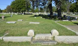
| Burial | : | Oak Hill Cemetery, Red Bluff, Tehama County, USA |
| Coordinate | : | 40.1699982, -122.2433014 |
| Plot | : | Lot 28, Blk 19, Grave 2 |
| Inscription | : | No marker. |
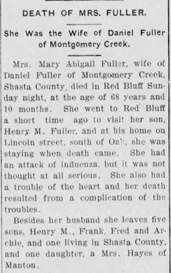
| Description | : | Red Bluff Daily News, Red Bluff, California, Tuesday, December 30, 1902, page 4, column 2, middle. "Death of an Old Lady" "Mrs. Mary Abigail Fuller, wife of Daniel Fuller of Montgomery Creek, Shasta County, died in this city about 11:30 o'clock Sunday night, at the age of 68 years and 10 months. She came here a short time ago to visit her son, Henry M. Fuller, and at his home on Lincoln Street, south of Oak, she was staying when death came. She had an attack of influenza but it was not thought... Read More |
frequently asked questions (FAQ):
-
Where is Mary Abigail Davis Fuller's memorial?
Mary Abigail Davis Fuller's memorial is located at: Oak Hill Cemetery, Red Bluff, Tehama County, USA.
-
When did Mary Abigail Davis Fuller death?
Mary Abigail Davis Fuller death on 28 Dec 1902 in Red Bluff, Tehama County, California, USA
-
Where are the coordinates of the Mary Abigail Davis Fuller's memorial?
Latitude: 40.1699982
Longitude: -122.2433014
Family Members:
Parent
Spouse

Siblings

Children

Flowers:


Nearby Cemetories:
1. Red Bluff Memorial Chapel Mausoleum & Columbarium
Red Bluff, Tehama County, USA
Coordinate: 40.1717130, -122.2466860
2. Saint Mary's Cemetery
Red Bluff, Tehama County, USA
Coordinate: 40.1716995, -122.2521973
3. Growney Ranch Family Cemetery
Red Bluff, Tehama County, USA
Coordinate: 40.1167300, -122.1952500
4. Los Molinos Cemetery
Los Molinos, Tehama County, USA
Coordinate: 40.0475650, -122.1011820
5. Tehama Cemetery
Tehama, Tehama County, USA
Coordinate: 40.0233002, -122.1433029
6. Red Bank Cemetery
Red Bank, Tehama County, USA
Coordinate: 40.1036970, -122.4458540
7. Inks Creek Cemetery
Tehama County, USA
Coordinate: 40.3419800, -122.1297100
8. Cottonwood Creek Ranch Cemetery
Cottonwood, Shasta County, USA
Coordinate: 40.3663100, -122.2598800
9. Cottonwood Cemetery
Cottonwood, Shasta County, USA
Coordinate: 40.3856100, -122.2936500
10. Major Pierson B Reading Family Cemetery
Cottonwood, Shasta County, USA
Coordinate: 40.3924300, -122.2126900
11. Sunset Hill Cemetery
Corning, Tehama County, USA
Coordinate: 39.9271600, -122.1586100
12. Sleepy Hollow Pet Cemetery
Anderson, Shasta County, USA
Coordinate: 40.4199430, -122.2858410
13. Rosewood Cemetery
Rosewood, Tehama County, USA
Coordinate: 40.2685360, -122.5575190
14. New Clairvaux Abbey Cemetery
Vina, Tehama County, USA
Coordinate: 39.9381450, -122.0641890
15. Anderson District Cemetery
Anderson, Shasta County, USA
Coordinate: 40.4419518, -122.2967300
16. Oddfellows Cemetery
Anderson, Shasta County, USA
Coordinate: 40.4431590, -122.2907070
17. Anderson Pioneer Cemetery
Anderson, Shasta County, USA
Coordinate: 40.4439011, -122.2904968
18. Vina Cemetery
Vina, Tehama County, USA
Coordinate: 39.9636440, -121.9957070
19. Lowrey Cemetery
Tehama County, USA
Coordinate: 40.0066986, -122.5635986
20. Cameron-Davis Cemetery
Tehama County, USA
Coordinate: 40.2709800, -121.8778500
21. Parkville Cemetery
Anderson, Shasta County, USA
Coordinate: 40.4640200, -122.1897500
22. Lanes Valley Cemetery
Paynes Creek, Tehama County, USA
Coordinate: 40.3998400, -121.9762400
23. Pinckney Cemetery
Cottonwood, Shasta County, USA
Coordinate: 40.3997002, -122.5180969
24. Kirkwood Cemetery
Corning, Tehama County, USA
Coordinate: 39.8624992, -122.1519012