
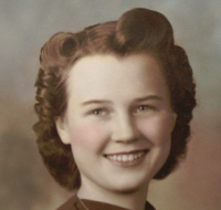
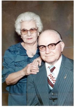
Mary Amazine Williams Pittman
| Birth | : | 1 Sep 1924 Adams, Gage County, Nebraska, USA |
| Death | : | 18 Oct 2013 Columbia, Boone County, Missouri, USA |
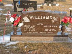
| Burial | : | Highland Cemetery, Adams, Gage County, USA |
| Coordinate | : | 40.4580994, -96.5196991 |
| Description | : | Mary Amazine Pittman, 89, of Columbia, MO died at the Columbia Healthcare Center on Friday, October 18, 2013. She was born on September 1, 1924 at Adams, Nebraska. She met the love of her life at an early age, John F. Pittman, and they married on July 28, 1943. Their engagement was extended, as she did not graduate until 1941, and the war kept John apart from her for 39 months. They lived and worked in Adams, raising three children, Dennis, Pamela and David. In 1979, she and John became Apartment Managers in Lakewood, Colorado. They... Read More |
frequently asked questions (FAQ):
-
Where is Mary Amazine Williams Pittman's memorial?
Mary Amazine Williams Pittman's memorial is located at: Highland Cemetery, Adams, Gage County, USA.
-
When did Mary Amazine Williams Pittman death?
Mary Amazine Williams Pittman death on 18 Oct 2013 in Columbia, Boone County, Missouri, USA
-
Where are the coordinates of the Mary Amazine Williams Pittman's memorial?
Latitude: 40.4580994
Longitude: -96.5196991
Family Members:
Parent
Spouse

Siblings
Flowers:


Nearby Cemetories:
1. Highland Cemetery
Adams, Gage County, USA
Coordinate: 40.4580994, -96.5196991
2. Hooker Cemetery
Adams, Gage County, USA
Coordinate: 40.4207993, -96.4732971
3. Grandview Cemetery
Gage County, USA
Coordinate: 40.4617004, -96.6091995
4. Granite Hill Cemetery
Johnson County, USA
Coordinate: 40.4180984, -96.4417038
5. Immanuel Cemetery
Sterling, Johnson County, USA
Coordinate: 40.4692001, -96.4253006
6. Latrobe Cemetery
Sterling, Johnson County, USA
Coordinate: 40.5151000, -96.4557000
7. Weber Cemetery
Sterling, Johnson County, USA
Coordinate: 40.4581000, -96.4177000
8. Saint Johns Lutheran Cemetery
Cortland, Gage County, USA
Coordinate: 40.5078300, -96.6252700
9. Firth Cemetery
Firth, Lancaster County, USA
Coordinate: 40.5250015, -96.6085968
10. Pella Cemetery
Panama, Lancaster County, USA
Coordinate: 40.5555992, -96.5014038
11. Saint John North Lutheran Cemetery
Sterling, Johnson County, USA
Coordinate: 40.4689500, -96.3878500
12. Sunnyside Cemetery
Cortland, Gage County, USA
Coordinate: 40.4799200, -96.6511800
13. South Saint John Lutheran Cemetery
Sterling, Johnson County, USA
Coordinate: 40.4355500, -96.3858000
14. Dietz Cemetery
Firth, Lancaster County, USA
Coordinate: 40.5449982, -96.6286011
15. Sterling Cemetery
Sterling, Johnson County, USA
Coordinate: 40.4585991, -96.3582993
16. Panama Cemetery
Panama, Lancaster County, USA
Coordinate: 40.5821991, -96.5255966
17. Zion Evangelical Lutheran Cemetery
Pickrell, Gage County, USA
Coordinate: 40.3456001, -96.6147003
18. Christ Lutheran Church Cemetery
Pickrell, Gage County, USA
Coordinate: 40.4079410, -96.6848370
19. Saint James Cemetery
Cortland, Gage County, USA
Coordinate: 40.4886050, -96.7036050
20. Cortland Cemetery
Cortland, Gage County, USA
Coordinate: 40.4879200, -96.7041250
21. Crab Orchard Cemetery
Crab Orchard, Johnson County, USA
Coordinate: 40.3274994, -96.4366989
22. Solon Cemetery
Otoe County, USA
Coordinate: 40.5917015, -96.4436035
23. Holland Cemetery
Holland, Lancaster County, USA
Coordinate: 40.5957985, -96.5997009
24. Rosehill Cemetery
Douglas, Otoe County, USA
Coordinate: 40.5845940, -96.3867900