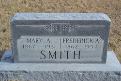
Mary Angelina Walker Smith
| Birth | : | 18 Mar 1867 Colorado, USA |
| Death | : | 3 Dec 1931 Independence, Jackson County, Missouri, USA |
| Burial | : | Hollen Cemetery, Hollen, Wellington County, Canada |
| Coordinate | : | 43.7064000, -80.7227300 |
frequently asked questions (FAQ):
-
Where is Mary Angelina Walker Smith's memorial?
Mary Angelina Walker Smith's memorial is located at: Hollen Cemetery, Hollen, Wellington County, Canada.
-
When did Mary Angelina Walker Smith death?
Mary Angelina Walker Smith death on 3 Dec 1931 in Independence, Jackson County, Missouri, USA
-
Where are the coordinates of the Mary Angelina Walker Smith's memorial?
Latitude: 43.7064000
Longitude: -80.7227300
Family Members:
Parent
Spouse
Siblings
Children
Flowers:
Nearby Cemetories:
1. Hollen Cemetery
Hollen, Wellington County, Canada
Coordinate: 43.7064000, -80.7227300
2. Spring Hill Methodist Cemetery
Peel Township, Wellington County, Canada
Coordinate: 43.6867500, -80.7110000
3. Glen Allan Cemetery
Glen Allan, Wellington County, Canada
Coordinate: 43.6627769, -80.7105560
4. Old Anglican Cemetery
Glen Allan, Wellington County, Canada
Coordinate: 43.6599000, -80.7136000
5. Saint James Anglican Pioneer Cemetery
Rothsay, Wellington County, Canada
Coordinate: 43.7451500, -80.6815333
6. Saint John's Anglican Cemetery
Moorefield, Wellington County, Canada
Coordinate: 43.7569444, -80.7413889
7. Goshen Mennonite Meeting House Cemetery
Wellington County, Canada
Coordinate: 43.6905556, -80.6425018
8. Cross/Goshen Wesleyan Cemetery
Mapleton Township, Wellington County, Canada
Coordinate: 43.6868930, -80.6415130
9. Drayton Methodist Church and Cemetery
Drayton, Wellington County, Canada
Coordinate: 43.7525000, -80.6641670
10. Zion Mennonite Cemetery
Mapleton Township, Wellington County, Canada
Coordinate: 43.7229600, -80.8063600
11. Sharron Cemetery
Lebanon, Wellington County, Canada
Coordinate: 43.7029400, -80.8151900
12. Olivet Mennonite Cemetery
Winfield, Wellington County, Canada
Coordinate: 43.6610413, -80.6478043
13. Drayton Victoria Cemetery
Drayton, Wellington County, Canada
Coordinate: 43.7651972, -80.6629083
14. Bethesda Community Cemetery
Moorefield, Wellington County, Canada
Coordinate: 43.7817530, -80.7380320
15. Saint Johns Lutheran Cemetery
Hesson, Perth County, Canada
Coordinate: 43.6395800, -80.7944900
16. Saint Marys Roman Catholic Cemetery
Hesson, Perth County, Canada
Coordinate: 43.6363869, -80.7906265
17. Saint Joseph's Roman Catholic Cemetery
Macton, Wellington County, Canada
Coordinate: 43.6231530, -80.6925200
18. Weaverland Mennonite Cemetery
Hesson, Perth County, Canada
Coordinate: 43.6258888, -80.7707977
19. Ebenezer Primitive Methodist Cemetery
Goldstone, Wellington County, Canada
Coordinate: 43.7291794, -80.6049728
20. British Methodist Episcopal Cemetery
Wallenstein, Wellington County, Canada
Coordinate: 43.6476850, -80.6238770
21. Olivet Cemetery
Mapleton Township, Wellington County, Canada
Coordinate: 43.6478752, -80.6153249
22. Berea Mennonite Cemetery
Bosworth, Wellington County, Canada
Coordinate: 43.7793980, -80.6300350
23. Zion Methodist Cemetery
Wallace Township, Perth County, Canada
Coordinate: 43.7663210, -80.8331110
24. Brookside Cemetery
Carthage, Perth County, Canada
Coordinate: 43.6629066, -80.8494186


