
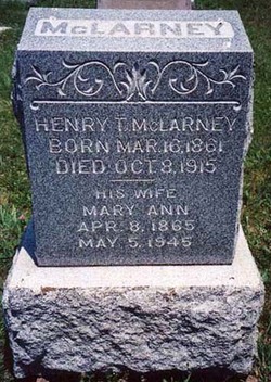
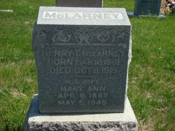
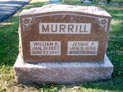
Mary Ann Murrill McLarney
| Birth | : | 8 Apr 1865 Bonne Terre, St. Francois County, Missouri, USA |
| Death | : | 5 May 1945 Farmington, St. Francois County, Missouri, USA |
| Burial | : | Potter Field, Omaha, Douglas County, USA |
| Coordinate | : | 41.3320274, -95.9902878 |
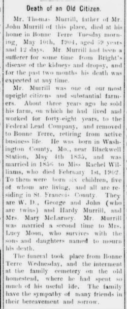
| Description | : | Mary Ann (Mrs. J. H.) Orten Lead Belt News, Flat River, St. Francois County, Missouri, May 11, 1945. MRS. J. H. ORTEN -- passed away at her home in Farmington, Mo., at 9:15 p.m., Saturday, May 5, 1945, at the age of 80 years 27 days. Funeral services were held Tuesday afternoon at the Murphy-Long Memorial Methodist Church, conducted by the pastor, Rev. S. C. Headrick. Interment was in Parkview Cemetery, with Cozean Service. Mary Ann Murrill, daughter of the late Thomas and Rachel Williams Murrill, was born near Bonne Terre, Missouri... Read More |
frequently asked questions (FAQ):
-
Where is Mary Ann Murrill McLarney's memorial?
Mary Ann Murrill McLarney's memorial is located at: Potter Field, Omaha, Douglas County, USA.
-
When did Mary Ann Murrill McLarney death?
Mary Ann Murrill McLarney death on 5 May 1945 in Farmington, St. Francois County, Missouri, USA
-
Where are the coordinates of the Mary Ann Murrill McLarney's memorial?
Latitude: 41.3320274
Longitude: -95.9902878
Family Members:
Parent

Spouse
Siblings
Children
Flowers:


Nearby Cemetories:
1. Potter Field
Omaha, Douglas County, USA
Coordinate: 41.3320274, -95.9902878
2. Forest Lawn Memorial Park
Omaha, Douglas County, USA
Coordinate: 41.3272018, -95.9847031
3. Pleasant Hill Jewish Cemetery
Omaha, Douglas County, USA
Coordinate: 41.3185997, -95.9766998
4. Mormon Pioneer Cemetery
Omaha, Douglas County, USA
Coordinate: 41.3348450, -95.9663720
5. Springwell Cemetery
Omaha, Douglas County, USA
Coordinate: 41.3114014, -96.0096970
6. Golden Hill Cemetery
Omaha, Douglas County, USA
Coordinate: 41.3050003, -95.9744034
7. Mount Sinai Cemetery
Omaha, Douglas County, USA
Coordinate: 41.3116989, -96.0314026
8. Servants of Mary Cemetery
Omaha, Douglas County, USA
Coordinate: 41.3017170, -96.0258260
9. Mount Hope Cemetery
Omaha, Douglas County, USA
Coordinate: 41.3041992, -96.0310974
10. Union Memorial Cemetery
Omaha, Douglas County, USA
Coordinate: 41.3512611, -96.0620193
11. Prospect Hill Cemetery
Omaha, Douglas County, USA
Coordinate: 41.2780991, -95.9593964
12. Shipley Cemetery
Washington County, USA
Coordinate: 41.3932991, -95.9828033
13. Nash Chapel Crypt
Omaha, Douglas County, USA
Coordinate: 41.2665090, -95.9721790
14. All Saints Episcopal Church Columbarium
Omaha, Douglas County, USA
Coordinate: 41.2785000, -96.0579000
15. Holy Sepulchre Cemetery
Omaha, Douglas County, USA
Coordinate: 41.2543983, -95.9875031
16. First Central Congregational Columbarium
Omaha, Douglas County, USA
Coordinate: 41.2563456, -95.9658365
17. Trinity Cathedral Columbarium
Omaha, Douglas County, USA
Coordinate: 41.2603900, -95.9393660
18. Douglas County Poor Farm Cemetery
Omaha, Douglas County, USA
Coordinate: 41.2437240, -95.9723480
19. Saint Andrews Episcopal Church Columbarium
Omaha, Douglas County, USA
Coordinate: 41.2492500, -96.0427500
20. Ak-Sar-Ben Racetrack Grounds
Omaha, Douglas County, USA
Coordinate: 41.2414703, -96.0159607
21. Bohemian Cemetery
Omaha, Douglas County, USA
Coordinate: 41.2388992, -95.9955978
22. Countryside Community Church Columbarium
Omaha, Douglas County, USA
Coordinate: 41.2483660, -96.0500270
23. Westlawn-Hillcrest Memorial Park
Omaha, Douglas County, USA
Coordinate: 41.2346992, -95.9966965
24. Evergreen Memorial Park Cemetery
Omaha, Douglas County, USA
Coordinate: 41.2393990, -96.0355988