

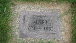
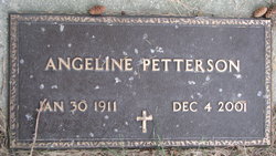
Mary Ann Nelson Dahlin
| Birth | : | 20 Jan 1871 Decorah, Winneshiek County, Iowa, USA |
| Death | : | 11 Nov 1952 Fargo, Cass County, North Dakota, USA |
| Burial | : | St. Mary's Churchyard, Brome, Mid Suffolk District, England |
| Coordinate | : | 52.3443800, 1.1475990 |
| Description | : | Funeral services will be held this afternoon, November 20, at two o'clock in the Quam Chapel for Mrs. Mary Anne Dahlin, who passed away at a Fargo hospital Tuesday morning of this week. Rev. A. O. Borlaug will officiate and burial will be in the Binford Cemetery. Mary Anne Nelson was born at Decorah, Iowa, May 20, 1871. She was married to Andrew Dahlin at Cooperstown in 1895. The couple resided at Binford until a few years before his death February 17, 1942. They had moved to Fargo where they lived with daughters Olga and Esther. Mrs. Dahlin had made... Read More |
frequently asked questions (FAQ):
-
Where is Mary Ann Nelson Dahlin's memorial?
Mary Ann Nelson Dahlin's memorial is located at: St. Mary's Churchyard, Brome, Mid Suffolk District, England.
-
When did Mary Ann Nelson Dahlin death?
Mary Ann Nelson Dahlin death on 11 Nov 1952 in Fargo, Cass County, North Dakota, USA
-
Where are the coordinates of the Mary Ann Nelson Dahlin's memorial?
Latitude: 52.3443800
Longitude: 1.1475990
Family Members:
Parent
Spouse

Siblings

Children
Flowers:


Nearby Cemetories:
1. St. Mary's Churchyard
Brome, Mid Suffolk District, England
Coordinate: 52.3443800, 1.1475990
2. St. Nicholas Churchyard
Oakley, Mid Suffolk District, England
Coordinate: 52.3518380, 1.1662190
3. All Saints Churchyard
Stuston, Mid Suffolk District, England
Coordinate: 52.3571980, 1.1332590
4. Eye War Memorial
Eye, Mid Suffolk District, England
Coordinate: 52.3213410, 1.1461480
5. Saint Andrew Churchyard
Scole, South Norfolk District, England
Coordinate: 52.3671670, 1.1579150
6. Saint Peter and Saint Paul Churchyard
Eye, Mid Suffolk District, England
Coordinate: 52.3200520, 1.1516450
7. Eye Cemetery
Eye, Mid Suffolk District, England
Coordinate: 52.3188270, 1.1371000
8. St Leonard Churchyard
Billingford, South Norfolk District, England
Coordinate: 52.3666290, 1.1834260
9. St Peter Churchyard
Palgrave, Mid Suffolk District, England
Coordinate: 52.3634190, 1.1059170
10. Saint Peter and St. Paul Churchyard
Hoxne, Mid Suffolk District, England
Coordinate: 52.3522270, 1.2016300
11. Unitarian Chapel Cemetery
Palgrave, Mid Suffolk District, England
Coordinate: 52.3693130, 1.1086820
12. St Andrew's Frenze Church
Scole, South Norfolk District, England
Coordinate: 52.3802000, 1.1361000
13. Saint Mary Churchyard
Diss, South Norfolk District, England
Coordinate: 52.3772370, 1.1097880
14. Diss War Memorial
Diss, South Norfolk District, England
Coordinate: 52.3773380, 1.1088530
15. Saint John The Baptist Churchyard
Denham, Mid Suffolk District, England
Coordinate: 52.3275300, 1.2101200
16. Croft Lane Baptist Church Burial Ground
Diss, South Norfolk District, England
Coordinate: 52.3771070, 1.1025490
17. St Mary's Church Burial Ground - old
Braiseworth, Mid Suffolk District, England
Coordinate: 52.3028860, 1.1277010
18. Braiseworth War Memorial
Braiseworth, Mid Suffolk District, England
Coordinate: 52.3027890, 1.1276970
19. Diss Cemetery
Diss, South Norfolk District, England
Coordinate: 52.3839060, 1.1115880
20. St Mary Churchyard
Thornham Parva, Mid Suffolk District, England
Coordinate: 52.3113910, 1.0926010
21. St Mary the Virgin Churchyard
Mellis, Mid Suffolk District, England
Coordinate: 52.3268950, 1.0725720
22. St. Michael's Churchyard
Occold, Mid Suffolk District, England
Coordinate: 52.2936170, 1.1598150
23. St. Remigius Churchyard
Roydon, South Norfolk District, England
Coordinate: 52.3815610, 1.0784680
24. Saint George Churchyard
Shimpling, South Norfolk District, England
Coordinate: 52.3993000, 1.1680000