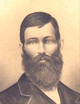
Mary Barr Moon
| Birth | : | 8 May 1819 USA |
| Death | : | 18 Apr 1898 Riley County, Kansas, USA |
| Burial | : | May Day Cemetery, Center Township, Riley County, USA |
| Coordinate | : | 39.4958000, -96.9302979 |
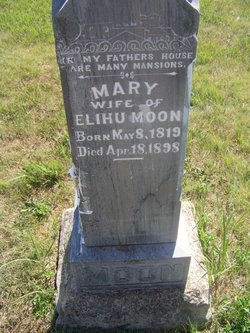
| Inscription | : | IN MY FATHERS HOUSE ARE MANY MANSIONS. Wife of Elihu Moon |
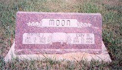
| Description | : | Wife of Elihu Moon. They married, 15 Feb., 1849 in Clinton County Ohio. Came to Riley County Kansas in 1858 in a covered wagon with all of their possesions and the first three of their seven children. Her name is actually on the tombstone of her husband's parents, James and Sarah Moon. Their names, birth and death dates are on three separate sides of the same stone. Her husband Elihu's stone sits next to this stone. |
frequently asked questions (FAQ):
-
Where is Mary Barr Moon's memorial?
Mary Barr Moon's memorial is located at: May Day Cemetery, Center Township, Riley County, USA.
-
When did Mary Barr Moon death?
Mary Barr Moon death on 18 Apr 1898 in Riley County, Kansas, USA
-
Where are the coordinates of the Mary Barr Moon's memorial?
Latitude: 39.4958000
Longitude: -96.9302979
Family Members:
Spouse
Children
Flowers:
Nearby Cemetories:
1. May Day Cemetery
Center Township, Riley County, USA
Coordinate: 39.4958000, -96.9302979
2. Fancy Creek Cemetery
Green, Clay County, USA
Coordinate: 39.4668999, -96.9969025
3. Appleton Cemetery
Clay County, USA
Coordinate: 39.5250015, -96.9972000
4. Pleasant Hill Cemetery
Leonardville, Riley County, USA
Coordinate: 39.4371210, -96.9426730
5. Saint Johns Lutheran Cemetery
Winkler, Riley County, USA
Coordinate: 39.4813995, -96.8494034
6. Zion Cemetery
Randolph, Riley County, USA
Coordinate: 39.5526139, -96.8853800
7. Goshen Central Cemetery
Clay Center, Clay County, USA
Coordinate: 39.5099983, -97.0160980
8. Teske Family Cemetery
Randolph, Riley County, USA
Coordinate: 39.4963830, -96.8294000
9. Brethren in Christ Cemetery
Clay County, USA
Coordinate: 39.4810982, -97.0344009
10. Joseph Sender Family Cemetery
Clay County, USA
Coordinate: 39.5090600, -97.0348800
11. Green Cemetery
Green, Clay County, USA
Coordinate: 39.4235992, -96.9882965
12. Crooked Creek Cemetery
Randolph, Riley County, USA
Coordinate: 39.4369011, -96.8480988
13. Lasita Cemetery
Leonardville, Riley County, USA
Coordinate: 39.4092900, -96.9422900
14. Peach Grove Cemetery
Randolph, Riley County, USA
Coordinate: 39.5494003, -96.8106003
15. Idylwilde Cemetery
Clay Center, Clay County, USA
Coordinate: 39.5097900, -97.0713000
16. Ebenezer Cemetery
Green, Clay County, USA
Coordinate: 39.3866997, -96.9974976
17. Hayes Cemetery
Clay County, USA
Coordinate: 39.4516983, -97.0811005
18. Leonardville Cemetery
Leonardville, Riley County, USA
Coordinate: 39.3792000, -96.8589020
19. Fancy Creek Randolph Cemetery
Randolph, Riley County, USA
Coordinate: 39.5149994, -96.7572021
20. Walsburg Lutheran Cemetery
Leonardville, Riley County, USA
Coordinate: 39.3931100, -96.8133200
21. Leonardville United Methodist Cemetery
Leonardville, Riley County, USA
Coordinate: 39.3568700, -96.8493600
22. Swedish Pleasant Hill Cemetery
Clay Center, Clay County, USA
Coordinate: 39.4735985, -97.1268997
23. Garfield Center Mission Cemetery
Clay Center, Clay County, USA
Coordinate: 39.5243100, -97.1277500
24. Clay County Poor Farm Cemetery
Clay Center, Clay County, USA
Coordinate: 39.3772700, -97.0727000

