

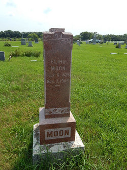
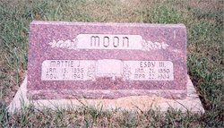
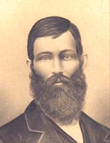
Elihu Moon
| Birth | : | 6 Jul 1826 Clinton County, Ohio, USA |
| Death | : | 3 Nov 1905 Randolph, Riley County, Kansas, USA |
| Burial | : | May Day Cemetery, Center Township, Riley County, USA |
| Coordinate | : | 39.4958000, -96.9302979 |
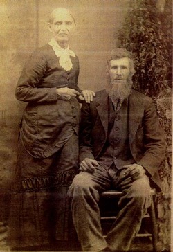
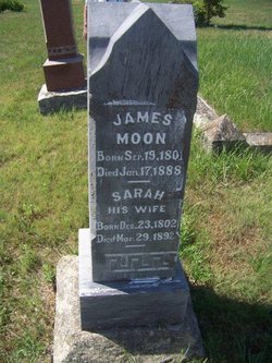
| Description | : | Elihu Moon was the son of James and Sarah (Clark) Moon. He is buried near Randolph in the May Day Cemetery.His occupation was that of a blacksmith and a farmer. He married Mary Barr on 15 Feb., 1849 in Clinton County Ohio. They came to Riley County in 1858. Their first home was on Walnut Creek, where it joins Fancy Creek. Later moved west on Fancy Creek near the Riley/Clay county lines. Elihu died from severe injuries while crossing the railroad tracks, and the train struck him. They say he was near deaf in later years & didn't hear ,... Read More |
frequently asked questions (FAQ):
-
Where is Elihu Moon's memorial?
Elihu Moon's memorial is located at: May Day Cemetery, Center Township, Riley County, USA.
-
When did Elihu Moon death?
Elihu Moon death on 3 Nov 1905 in Randolph, Riley County, Kansas, USA
-
Where are the coordinates of the Elihu Moon's memorial?
Latitude: 39.4958000
Longitude: -96.9302979
Family Members:
Parent

Spouse
Siblings
Children
Flowers:


Nearby Cemetories:
1. May Day Cemetery
Center Township, Riley County, USA
Coordinate: 39.4958000, -96.9302979
2. Fancy Creek Cemetery
Green, Clay County, USA
Coordinate: 39.4668999, -96.9969025
3. Appleton Cemetery
Clay County, USA
Coordinate: 39.5250015, -96.9972000
4. Pleasant Hill Cemetery
Leonardville, Riley County, USA
Coordinate: 39.4371210, -96.9426730
5. Saint Johns Lutheran Cemetery
Winkler, Riley County, USA
Coordinate: 39.4813995, -96.8494034
6. Zion Cemetery
Randolph, Riley County, USA
Coordinate: 39.5526139, -96.8853800
7. Goshen Central Cemetery
Clay Center, Clay County, USA
Coordinate: 39.5099983, -97.0160980
8. Teske Family Cemetery
Randolph, Riley County, USA
Coordinate: 39.4963830, -96.8294000
9. Brethren in Christ Cemetery
Clay County, USA
Coordinate: 39.4810982, -97.0344009
10. Joseph Sender Family Cemetery
Clay County, USA
Coordinate: 39.5090600, -97.0348800
11. Green Cemetery
Green, Clay County, USA
Coordinate: 39.4235992, -96.9882965
12. Crooked Creek Cemetery
Randolph, Riley County, USA
Coordinate: 39.4369011, -96.8480988
13. Lasita Cemetery
Leonardville, Riley County, USA
Coordinate: 39.4092900, -96.9422900
14. Peach Grove Cemetery
Randolph, Riley County, USA
Coordinate: 39.5494003, -96.8106003
15. Idylwilde Cemetery
Clay Center, Clay County, USA
Coordinate: 39.5097900, -97.0713000
16. Ebenezer Cemetery
Green, Clay County, USA
Coordinate: 39.3866997, -96.9974976
17. Hayes Cemetery
Clay County, USA
Coordinate: 39.4516983, -97.0811005
18. Leonardville Cemetery
Leonardville, Riley County, USA
Coordinate: 39.3792000, -96.8589020
19. Fancy Creek Randolph Cemetery
Randolph, Riley County, USA
Coordinate: 39.5149994, -96.7572021
20. Walsburg Lutheran Cemetery
Leonardville, Riley County, USA
Coordinate: 39.3931100, -96.8133200
21. Leonardville United Methodist Cemetery
Leonardville, Riley County, USA
Coordinate: 39.3568700, -96.8493600
22. Swedish Pleasant Hill Cemetery
Clay Center, Clay County, USA
Coordinate: 39.4735985, -97.1268997
23. Garfield Center Mission Cemetery
Clay Center, Clay County, USA
Coordinate: 39.5243100, -97.1277500
24. Clay County Poor Farm Cemetery
Clay Center, Clay County, USA
Coordinate: 39.3772700, -97.0727000