
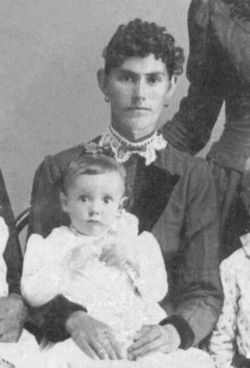
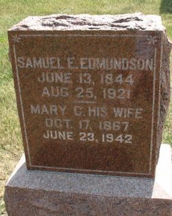
Mary Caroline “Cannie” Moss Edmundson
| Birth | : | 17 Oct 1867 Bowling Green, Clay County, Indiana, USA |
| Death | : | 23 Jun 1942 Minburn, Dallas County, Iowa, USA |
| Burial | : | Pleasington Priory, Pleasington, Blackburn with Darwen Unitary Authority, England |
| Coordinate | : | 53.7348590, -2.5433060 |
| Description | : | Mary Caroline Moss is the mother of six children. Two are from her first marriage to John L Fisher (1866-1892) and the other four are from her marriage to Samuel Edgar Edmundson. Mary Parnell married Samuel Edgar Edmundson on 10 jan 1867 in Dallas County, Iowa. The same year that Samuel's second wife was born. Birth 1847 in Ohio. She died after at least six children were born including Bertha J Edmundson (the sixth I believe). Bertha's mother is listed as Mary Pernell/Parnell on her marriage record. |
frequently asked questions (FAQ):
-
Where is Mary Caroline “Cannie” Moss Edmundson's memorial?
Mary Caroline “Cannie” Moss Edmundson's memorial is located at: Pleasington Priory, Pleasington, Blackburn with Darwen Unitary Authority, England.
-
When did Mary Caroline “Cannie” Moss Edmundson death?
Mary Caroline “Cannie” Moss Edmundson death on 23 Jun 1942 in Minburn, Dallas County, Iowa, USA
-
Where are the coordinates of the Mary Caroline “Cannie” Moss Edmundson's memorial?
Latitude: 53.7348590
Longitude: -2.5433060
Family Members:

Spouse

Siblings
Children


Nearby Cemetories:
1. Pleasington Priory
Pleasington, Blackburn with Darwen Unitary Authority, England
Coordinate: 53.7348590, -2.5433060
2. Pleasington Cemetery and Crematorium
Blackburn, Blackburn with Darwen Unitary Authority, England
Coordinate: 53.7388880, -2.5368710
3. Holy Trinity Churchyard
Hoghton, Chorley Borough, England
Coordinate: 53.7279300, -2.5848550
4. St. Josephs Roman Catholic Churchyard
Brindle, Chorley Borough, England
Coordinate: 53.7350780, -2.5880640
5. New Row Methodist Church
Blackburn with Darwen Unitary Authority, England
Coordinate: 53.7208950, -2.5023720
6. St Stephen Churchyard
Tockholes, Blackburn with Darwen Unitary Authority, England
Coordinate: 53.7058350, -2.5169320
7. St. Peter's Churchyard
Blackburn, Blackburn with Darwen Unitary Authority, England
Coordinate: 53.7448110, -2.4865070
8. St Paul's
Blackburn, Blackburn with Darwen Unitary Authority, England
Coordinate: 53.7491222, -2.4891266
9. Independent Chapel Churchyard
Blackburn, Blackburn with Darwen Unitary Authority, England
Coordinate: 53.7454960, -2.4864460
10. Wesleyan Methodist Chapel Chapelyard
Blackburn, Blackburn with Darwen Unitary Authority, England
Coordinate: 53.7464910, -2.4848380
11. Blackburn Cathedral
Blackburn, Blackburn with Darwen Unitary Authority, England
Coordinate: 53.7472960, -2.4820020
12. St. Mary's Churchyard
Mellor, Ribble Valley Borough, England
Coordinate: 53.7728600, -2.5312400
13. St Paul's Churchyard
Withnell, Chorley Borough, England
Coordinate: 53.6970740, -2.5592150
14. Mellor Methodist Churchyard
Blackburn, Blackburn with Darwen Unitary Authority, England
Coordinate: 53.7742950, -2.5255060
15. Mount St Presbyterian Chapelyard
Blackburn, Blackburn with Darwen Unitary Authority, England
Coordinate: 53.7478000, -2.4775000
16. Holy Trinity Church
Blackburn with Darwen Unitary Authority, England
Coordinate: 53.7511727, -2.4747178
17. St James's Churchyard
Brindle, Chorley Borough, England
Coordinate: 53.7133333, -2.6086111
18. St Alban's Churchyard
Blackburn, Blackburn with Darwen Unitary Authority, England
Coordinate: 53.7530090, -2.4748540
19. St Mary's R.C. Church Cemetery
Osbaldeston, Ribble Valley Borough, England
Coordinate: 53.7816970, -2.5350240
20. St James Churchyard
Lower Darwen, Blackburn with Darwen Unitary Authority, England
Coordinate: 53.7245510, -2.4634700
21. St Leonard Churchyard
Balderstone, Ribble Valley Borough, England
Coordinate: 53.7860070, -2.5609380
22. Blackburn Cemetery
Blackburn, Blackburn with Darwen Unitary Authority, England
Coordinate: 53.7662430, -2.4726050
23. St. Mary's and St. John RC Churchyard, Southworth
Samlesbury, South Ribble Borough, England
Coordinate: 53.7676690, -2.6183400
24. St. Leonard the Less Churchyard
Samlesbury, South Ribble Borough, England
Coordinate: 53.7680000, -2.6237000