

Mary Catherine Powley Fields
| Birth | : | 22 Aug 1925 Dunlap, Harrison County, Iowa, USA |
| Death | : | Mar 1984 Omaha, Douglas County, Nebraska, USA |
| Burial | : | St Michael and All Angels Churchyard, Twerton, Bath and North East Somerset Unitary Authority, England |
| Coordinate | : | 51.3809000, -2.3981000 |
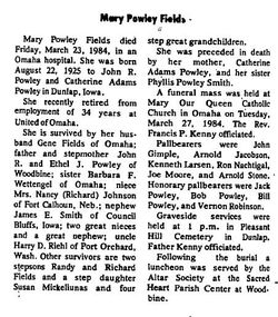
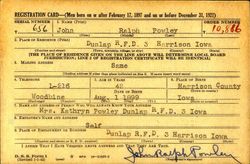
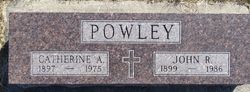
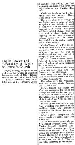
| Description | : | Fields, Mary Powley - Dunlap Reporter, Dunlap, Iowa, Thursday, April 5th, 1984 Page 7 Mary Powley Fields died Friday, March 23, 1984, in an Omaha hospital. She was born August 22, 1925 to John R. Powley and Catherine Adams Powley in Dunlap, Iowa. She recently retired from employment of 34 years at United of Omaha. She is survived by her husband Gene Fields of Omaha; father and stepmother John R. and Ethel J . Powley of Woodbine; sister Barbara F. Wettengel of Omaha; niece Mrs. Nancy (Richard) Johnson of Fort Calhoun, Neb.; nephew James E. Smith of... Read More |
frequently asked questions (FAQ):
-
Where is Mary Catherine Powley Fields's memorial?
Mary Catherine Powley Fields's memorial is located at: St Michael and All Angels Churchyard, Twerton, Bath and North East Somerset Unitary Authority, England.
-
When did Mary Catherine Powley Fields death?
Mary Catherine Powley Fields death on Mar 1984 in Omaha, Douglas County, Nebraska, USA
-
Where are the coordinates of the Mary Catherine Powley Fields's memorial?
Latitude: 51.3809000
Longitude: -2.3981000
Family Members:
Parent
Spouse
Siblings

Flowers:


Nearby Cemetories:
1. St Michael and All Angels Churchyard
Twerton, Bath and North East Somerset Unitary Authority, England
Coordinate: 51.3809000, -2.3981000
2. Locksbrook Cemetery
Lower Weston, Bath and North East Somerset Unitary Authority, England
Coordinate: 51.3845180, -2.3850300
3. Twerton Cemetery
Twerton, Bath and North East Somerset Unitary Authority, England
Coordinate: 51.3802500, -2.3836220
4. Locksbrook St Saviour's Cemetery
Bath and North East Somerset Unitary Authority, England
Coordinate: 51.3867880, -2.3863380
5. Haycombe Cemetery and Crematorium
Bath, Bath and North East Somerset Unitary Authority, England
Coordinate: 51.3703430, -2.4014760
6. St. Michael's Cemetery
Bath, Bath and North East Somerset Unitary Authority, England
Coordinate: 51.3859700, -2.3814500
7. Moravian Burial Ground
Bath, Bath and North East Somerset Unitary Authority, England
Coordinate: 51.3894150, -2.3798150
8. All Saints Churchyard
Weston, Bath and North East Somerset Unitary Authority, England
Coordinate: 51.3956850, -2.3881320
9. St. James' Cemetery
Bath, Bath and North East Somerset Unitary Authority, England
Coordinate: 51.3802000, -2.3722200
10. Countess of Huntingdon's Chapel
Walcot, Bath and North East Somerset Unitary Authority, England
Coordinate: 51.3967020, -2.3907434
11. St Peter Churchyard
Englishcombe, Bath and North East Somerset Unitary Authority, England
Coordinate: 51.3640600, -2.4088700
12. Holy Trinity Churchyard
Newton St Loe, Bath and North East Somerset Unitary Authority, England
Coordinate: 51.3820470, -2.4311300
13. St Mary's Chapel, Queens Square
Bath, Bath and North East Somerset Unitary Authority, England
Coordinate: 51.3827790, -2.3649790
14. St Mary Magdalen Chapel
Widcombe, Bath and North East Somerset Unitary Authority, England
Coordinate: 51.3760486, -2.3643405
15. Bath General Hospital Burial Ground
Bath and North East Somerset Unitary Authority, England
Coordinate: 51.3824715, -2.3614742
16. St James Old Burial Ground
Bath, Bath and North East Somerset Unitary Authority, England
Coordinate: 51.3798600, -2.3610100
17. Quaker Meeting House
Bath, Bath and North East Somerset Unitary Authority, England
Coordinate: 51.3823280, -2.3604380
18. St. Mary de Stall Churchyard (Defunct)
Bath, Bath and North East Somerset Unitary Authority, England
Coordinate: 51.3813350, -2.3600353
19. Ss Michael & Paul Churchyard
Bath, Bath and North East Somerset Unitary Authority, England
Coordinate: 51.3834970, -2.3596980
20. St. Michael's Burial Ground
Bath, Bath and North East Somerset Unitary Authority, England
Coordinate: 51.3838810, -2.3594090
21. Bath Abbey
Bath, Bath and North East Somerset Unitary Authority, England
Coordinate: 51.3815310, -2.3586640
22. Saint Mark's Churchyard
Widcombe, Bath and North East Somerset Unitary Authority, England
Coordinate: 51.3766660, -2.3588010
23. Old Orchard Street Catholic Burial Vault
Bath, Bath and North East Somerset Unitary Authority, England
Coordinate: 51.3800370, -2.3579910
24. St. Swithin Churchyard
Bath, Bath and North East Somerset Unitary Authority, England
Coordinate: 51.3885480, -2.3594500