
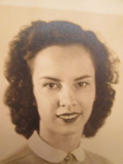
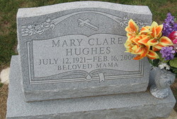
Mary Clare Higginbotham Hughes
| Birth | : | 12 Jul 1921 Nelson County, Virginia, USA |
| Death | : | 16 Feb 2006 Staunton, Staunton City, Virginia, USA |
| Burial | : | Sacramento City Cemetery, Sacramento, Sacramento County, USA |
| Coordinate | : | 38.5636864, -121.5009537 |
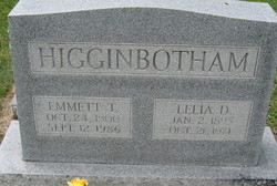
| Description | : | Mary Clare Hughes, 84, a resident of Loyalton of Staunton, and formerly of King Avenue, in Waynesboro, died Feb. 16, 2006. She was born in Nelson County on July 12, 1921, a daughter of the late Emmett Theodore and Lelia Clare Higginbotham. Mary Clare was a member of the First Baptist Church of Waynesboro, where she served as a Sunday school teacher, BTU leader and was an active member of the Women's Missionary Union. In addition she was a Meals on Wheels volunteer. She was preceded in death by her sister, Margaret T. Arrowood; and... Read More |
frequently asked questions (FAQ):
-
Where is Mary Clare Higginbotham Hughes's memorial?
Mary Clare Higginbotham Hughes's memorial is located at: Sacramento City Cemetery, Sacramento, Sacramento County, USA.
-
When did Mary Clare Higginbotham Hughes death?
Mary Clare Higginbotham Hughes death on 16 Feb 2006 in Staunton, Staunton City, Virginia, USA
-
Where are the coordinates of the Mary Clare Higginbotham Hughes's memorial?
Latitude: 38.5636864
Longitude: -121.5009537
Family Members:
Parent

Spouse
Siblings
Children
Flowers:


Nearby Cemetories:
1. Sacramento City Cemetery
Sacramento, Sacramento County, USA
Coordinate: 38.5636864, -121.5009537
2. Buddhist Church of Sacramento Nokotsudo
Sacramento, Sacramento County, USA
Coordinate: 38.5639300, -121.4978400
3. Sunset Hill Cemetery
Sacramento, Sacramento County, USA
Coordinate: 38.5608000, -121.5037300
4. Masonic Lawn Cemetery
Sacramento, Sacramento County, USA
Coordinate: 38.5604720, -121.5032600
5. Odd Fellows Lawn Cemetery and Mausoleum
Sacramento, Sacramento County, USA
Coordinate: 38.5585000, -121.5011000
6. National Shrine of Our Lady of Guadalupe Crypt
Sacramento, Sacramento County, USA
Coordinate: 38.5704800, -121.5014400
7. California State Capitol
Sacramento, Sacramento County, USA
Coordinate: 38.5760994, -121.4931488
8. Saint Joseph Cemetery
Sacramento, Sacramento County, USA
Coordinate: 38.5574989, -121.4835968
9. Holy Ascension Russian Orthodox Cemetery
Sacramento, Sacramento County, USA
Coordinate: 38.5846212, -121.4936736
10. Trinity Episcopal Cathedral Columbarium
Sacramento, Sacramento County, USA
Coordinate: 38.5705500, -121.4723770
11. New Helvetia Cemetery (Defunct)
Sacramento, Sacramento County, USA
Coordinate: 38.5731600, -121.4639900
12. Pho Minh Temple Columbarium
Sacramento, Sacramento County, USA
Coordinate: 38.5340100, -121.4769000
13. East Lawn Memorial Park
Sacramento, Sacramento County, USA
Coordinate: 38.5612960, -121.4492760
14. Saint Rose Cemetery (Defunct)
Sacramento, Sacramento County, USA
Coordinate: 38.5208015, -121.4672012
15. Saint Mary's Catholic Cemetery and Mausoleum
Sacramento, Sacramento County, USA
Coordinate: 38.5298900, -121.4261200
16. Sacramento Memorial Lawn Cemetery
Sacramento, Sacramento County, USA
Coordinate: 38.5146484, -121.4380341
17. Sacramento County Hospital Cemetery
Sacramento, Sacramento County, USA
Coordinate: 38.5289300, -121.4239100
18. Home of Peace Cemetery
Sacramento, Sacramento County, USA
Coordinate: 38.5137558, -121.4382782
19. Russian Orthodox Cemetery
Sacramento, Sacramento County, USA
Coordinate: 38.5268800, -121.4244300
20. Sacramento County Cemetery
Sacramento County, USA
Coordinate: 38.5267900, -121.4233700
21. Sacramento County Veterans Memorial Cemetery
Sacramento, Sacramento County, USA
Coordinate: 38.5252838, -121.4239120
22. Tinh Xa Ngoc An Temple Columbarium
Sacramento, Sacramento County, USA
Coordinate: 38.5190200, -121.4159500
23. Elder Creek Cemetery
Florin, Sacramento County, USA
Coordinate: 38.5111008, -121.4169006
24. Kim Quang Temple Columbarium
Sacramento, Sacramento County, USA
Coordinate: 38.5996600, -121.3904700