
| Birth | : | Sep 1868 Ogle County, Illinois, USA |
| Death | : | 15 May 1898 Cloud County, Kansas, USA |
| Burial | : | Morrison Cemetery, Center Township, Cloud County, USA |
| Coordinate | : | 39.4817009, -97.7975006 |
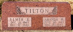
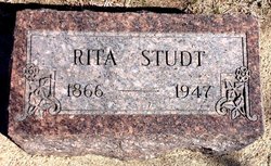
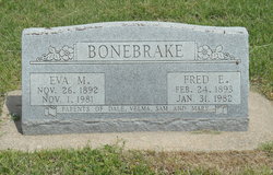
| Description | : | Mary Elizabeth "Matie" was born, near Franklin Grove, IL, in 1868. Her parents were Benjamin Franklin (B.F.) Tilton (1832-1918) and Rebecca Payne Tilton ((1840-1895). Her siblings were Elmer E., b. 1863, and Rita, b. 1866. The family moved to Arion Twp, Cloud Co., KS about 1880. Matie married Samuel Bonebrake, a neighbor lad, on 4 Oct 1888. They had these sons: Charles Emery (1889- 1968); Fred (1893-1961); Samuel Edwin "Eddie", (1895-1965); and Curtis (b. and d. 15 May 1898). Evidently Matie died in childbirth, 15 May 1898, as she and Curtis are buried together, in the Morrison Cemetery, near her mother... Read More |
frequently asked questions (FAQ):
-
Where is Mary Elizabeth “Matie” Tilton Bonebrake's memorial?
Mary Elizabeth “Matie” Tilton Bonebrake's memorial is located at: Morrison Cemetery, Center Township, Cloud County, USA.
-
When did Mary Elizabeth “Matie” Tilton Bonebrake death?
Mary Elizabeth “Matie” Tilton Bonebrake death on 15 May 1898 in Cloud County, Kansas, USA
-
Where are the coordinates of the Mary Elizabeth “Matie” Tilton Bonebrake's memorial?
Latitude: 39.4817009
Longitude: -97.7975006
Family Members:
Parent

Spouse
Siblings
Children
Flowers:


Nearby Cemetories:
1. Morrison Cemetery
Center Township, Cloud County, USA
Coordinate: 39.4817009, -97.7975006
2. Summit Cemetery
Jamestown, Cloud County, USA
Coordinate: 39.4813200, -97.8628800
3. Wilcox Cemetery
Cloud County, USA
Coordinate: 39.4925003, -97.7313995
4. West Branch Cemetery
Buffalo Township, Cloud County, USA
Coordinate: 39.5391998, -97.7457962
5. West Summit Cemetery
Jamestown, Cloud County, USA
Coordinate: 39.5532900, -97.8312600
6. Hall Cemetery
Cloud County, USA
Coordinate: 39.4455986, -97.7033005
7. Hefner Cemetery
Cloud County, USA
Coordinate: 39.5393400, -97.7218400
8. Summit Cemetery #3
Macyville, Cloud County, USA
Coordinate: 39.5258330, -97.9194440
9. Fairview Cemetery
Buffalo Township, Cloud County, USA
Coordinate: 39.5889015, -97.7724991
10. Kindel Cemetery
Center Township, Cloud County, USA
Coordinate: 39.4519005, -97.6464005
11. Saint Marys Catholic Cemetery
Glasco, Cloud County, USA
Coordinate: 39.3574000, -97.8245000
12. Glasco Cemetery
Glasco, Cloud County, USA
Coordinate: 39.3574000, -97.8265000
13. Pleasant Hill Cemetery
Concordia, Cloud County, USA
Coordinate: 39.5583000, -97.6639023
14. West Asher Cemetery
Scottsville, Mitchell County, USA
Coordinate: 39.4815000, -97.9661600
15. Nazareth Convent Cemetery
Concordia, Cloud County, USA
Coordinate: 39.5614000, -97.6612000
16. Jamestown Cemetery
Jamestown, Cloud County, USA
Coordinate: 39.5964012, -97.8839035
17. Scottsville Cemetery
Scottsville, Mitchell County, USA
Coordinate: 39.5468102, -97.9474945
18. Pleasant Hill Cemetery
Huscher, Cloud County, USA
Coordinate: 39.5093994, -97.6292038
19. Saint Mary's Cemetery
Jamestown, Cloud County, USA
Coordinate: 39.5964012, -97.8850021
20. Saint Concordia Cemetery
Concordia, Cloud County, USA
Coordinate: 39.5593800, -97.6503100
21. Asherville Cemetery
Asherville, Mitchell County, USA
Coordinate: 39.4205000, -97.9672900
22. Ezra Adkins Gravesite
Cloud County, USA
Coordinate: 39.6234500, -97.7372900
23. McBride Cemetery
Beloit, Mitchell County, USA
Coordinate: 39.4808006, -97.9907990
24. Bethel Cemetery
Meredith Township, Cloud County, USA
Coordinate: 39.3506000, -97.7029000