
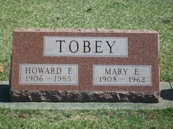
Mary Ellen Newell Tobey
| Birth | : | 24 Dec 1908 |
| Death | : | 23 Feb 1962 |
| Burial | : | Eltham Cemetery, Eltham, South Taranaki District, New Zealand |
| Coordinate | : | -39.4197140, 174.3251260 |
| Plot | : | Section 15, Row 8 |
| Description | : | Published in The Rochester News-Sentinel Saturday, February 24, 1962 Mary E. Tobey Mrs. Mary Ellen TOBEY, 53, secretary of the Fulton County Republican Central Committee and former manager of the County Auto License Branch, died Friday at 8 p.m. in Woodlawn hospital. She had been a hospital patient two weeks and ill for the past seven weeks. Mrs. Tobey resided on R.R. 1, Rochester, in the Woodrow community. Long active in Republican party work, she had been secretary of the party here for 15 years and operated the license branch from 1950-57. Born at Athens on Dec. 24, 1908, she was the daughter of Raymond and... Read More |
frequently asked questions (FAQ):
-
Where is Mary Ellen Newell Tobey's memorial?
Mary Ellen Newell Tobey's memorial is located at: Eltham Cemetery, Eltham, South Taranaki District, New Zealand.
-
When did Mary Ellen Newell Tobey death?
Mary Ellen Newell Tobey death on 23 Feb 1962 in
-
Where are the coordinates of the Mary Ellen Newell Tobey's memorial?
Latitude: -39.4197140
Longitude: 174.3251260
Family Members:
Parent

Spouse

Siblings
Children
Flowers:


Nearby Cemetories:
1. Eltham Cemetery
Eltham, South Taranaki District, New Zealand
Coordinate: -39.4197140, 174.3251260
2. Kopuatama Cemetery
Stratford, Stratford District, New Zealand
Coordinate: -39.3364400, 174.3364500
3. Pioneer Cemetery
Stratford, Stratford District, New Zealand
Coordinate: -39.3359800, 174.2929000
4. Te Utinga Urupā
Normanby, South Taranaki District, New Zealand
Coordinate: -39.5330847, 174.2761055
5. Weri Weri Urupa Aotearoa Marae
Okaiawa, South Taranaki District, New Zealand
Coordinate: -39.5190700, 174.2206700
6. Te Ngutu o te Manu Battlesite Memorial
Kapuni, South Taranaki District, New Zealand
Coordinate: -39.4876351, 174.1838147
7. Kaponga Cemetery
Kaponga, South Taranaki District, New Zealand
Coordinate: -39.4312210, 174.1553160
8. Midhirst Old Cemetery
Midhirst, Stratford District, New Zealand
Coordinate: -39.2911920, 174.2731980
9. Midhirst Cemetery
Midhirst, Stratford District, New Zealand
Coordinate: -39.2913640, 174.2724620
10. Waihi Cemetery and Redoubt
Normanby, South Taranaki District, New Zealand
Coordinate: -39.5444930, 174.2566820
11. Okaiawa Cemetery
Okaiawa, South Taranaki District, New Zealand
Coordinate: -39.5310220, 174.2042180
12. Tiwhaiti Urupa (Taiporohenui Marae)
Hāwera, South Taranaki District, New Zealand
Coordinate: -39.5741843, 174.3216120
13. Hāwera Cemetery
Hāwera, South Taranaki District, New Zealand
Coordinate: -39.5897900, 174.2945500
14. Motuawa Urupā Waiokura Marae
Manaia, South Taranaki District, New Zealand
Coordinate: -39.5388010, 174.1438990
15. Ohawe Military Cemetery
Ohawe Beach, South Taranaki District, New Zealand
Coordinate: -39.5835138, 174.2003758
16. Manaia Redoubt
Manaia, South Taranaki District, New Zealand
Coordinate: -39.5461557, 174.1364306
17. Manaia Cemetery
Manaia, South Taranaki District, New Zealand
Coordinate: -39.5575010, 174.1354470
18. Manutahi Cemetery
Manutahi, South Taranaki District, New Zealand
Coordinate: -39.6594677, 174.3924181
19. Tarata Cemetery
Tarata, New Plymouth District, New Zealand
Coordinate: -39.1496000, 174.3658200
20. Inglewood Cemetery
Inglewood, New Plymouth District, New Zealand
Coordinate: -39.1554140, 174.2145930
21. Otakeho Cemetery
New Plymouth, New Plymouth District, New Zealand
Coordinate: -39.5492080, 174.0051880
22. Purangi Cemetery
Purangi, New Plymouth District, New Zealand
Coordinate: -39.1571550, 174.5287180
23. Pihama Cemetery
Pihama, South Taranaki District, New Zealand
Coordinate: -39.5075300, 173.9285600
24. Mangapouri Cemetery
Egmont Village, New Plymouth District, New Zealand
Coordinate: -39.1347278, 174.1282396