
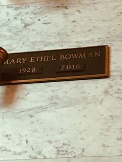
Mary Ethel Tucker Bowman
| Birth | : | 25 Nov 1928 Surry County, North Carolina, USA |
| Death | : | 2 Sep 2016 Jamestown, Guilford County, North Carolina, USA |
| Burial | : | Skyline Memory Gardens, Mount Airy, Surry County, USA |
| Coordinate | : | 36.4745610, -80.5856500 |
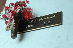
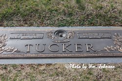
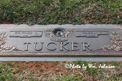
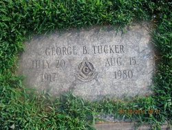
| Description | : | DOBSON, NC ~ Mrs. Mary Ethel Tucker Bowman, age 87, died Friday, September 2, 2016 at The Shannon Gray Rehabilitation Center. She was born November 25, 1928 in Surry County, NC to the late George Arthur Tucker & Regina Jackson Tucker. Mrs. Bowman retired from Sara Lee and was a member of Siloam Baptist Church. She is survived by her son & daughter-in-law; grandchildren; great-grandchildren; and brother & sister-in-law. In addition to her parents, Mrs. Bowman was preceded in death by her husband, Jesse Radford Bowman; sister, Lillian Tucker, and brothers: Joel Dennis Tucker, Howard Lee Tucker, George Burnis Tucker & Raymond “Buck” Tucker. A... Read More |
frequently asked questions (FAQ):
-
Where is Mary Ethel Tucker Bowman's memorial?
Mary Ethel Tucker Bowman's memorial is located at: Skyline Memory Gardens, Mount Airy, Surry County, USA.
-
When did Mary Ethel Tucker Bowman death?
Mary Ethel Tucker Bowman death on 2 Sep 2016 in Jamestown, Guilford County, North Carolina, USA
-
Where are the coordinates of the Mary Ethel Tucker Bowman's memorial?
Latitude: 36.4745610
Longitude: -80.5856500
Family Members:
Parent

Spouse
Siblings
Flowers:


Nearby Cemetories:
1. Skyline Memory Gardens
Mount Airy, Surry County, USA
Coordinate: 36.4745610, -80.5856500
2. Smith Family Cemetery
Mount Airy, Surry County, USA
Coordinate: 36.4773598, -80.5760269
3. Southside Baptist Church Cemetery
Boones Hill, Surry County, USA
Coordinate: 36.4725280, -80.5729720
4. Oak Grove United Methodist Church Cemetery
Oak Grove (Mount Airy South), Surry County, USA
Coordinate: 36.4899770, -80.5757520
5. Haymore Family Cemetery
Mount Airy, Surry County, USA
Coordinate: 36.4812486, -80.5608610
6. McGee Cemetery
Mount Airy, Surry County, USA
Coordinate: 36.4550800, -80.5700400
7. Old Methodist Cemetery
Mount Airy, Surry County, USA
Coordinate: 36.4948349, -80.6033630
8. Holly Springs Baptist Church Cemetery
Holly Springs, Surry County, USA
Coordinate: 36.4625816, -80.5570297
9. Mount Calvary Christian Methodist Episcopal Cemetery
Combstown, Surry County, USA
Coordinate: 36.5005470, -80.5794810
10. W.C. Hiatt Cemetery
Mount Airy, Surry County, USA
Coordinate: 36.4484329, -80.5796204
11. First Presbyterian Church Columbarium
Mount Airy, Surry County, USA
Coordinate: 36.4971990, -80.6057260
12. Norman Family Cemetery
Mount Airy, Surry County, USA
Coordinate: 36.4867516, -80.6183090
13. Doss Cemetery
Mount Airy, Surry County, USA
Coordinate: 36.4553337, -80.6131363
14. Forkner Cemetery
Mount Airy, Surry County, USA
Coordinate: 36.4978900, -80.5628510
15. James Monroe Hiatt Memorial Cemetery
Sheltontown, Surry County, USA
Coordinate: 36.4937782, -80.5521698
16. Midkiff Cemetery
Flat Rock, Surry County, USA
Coordinate: 36.5038986, -80.5642014
17. Flat Rock Baptist Cemetery
Flat Rock, Surry County, USA
Coordinate: 36.5085983, -80.5749969
18. Peoples Church Cemetery
Holly Springs, Surry County, USA
Coordinate: 36.4501100, -80.5525000
19. Kirkman Family Cemetery
Sheltontown, Surry County, USA
Coordinate: 36.4851110, -80.5421120
20. Shelton Church Of The Brethren Cemetery
Sheltontown, Surry County, USA
Coordinate: 36.4945180, -80.5473210
21. First Baptist Church Columbarium
Mount Airy, Surry County, USA
Coordinate: 36.5071760, -80.6085860
22. Kirkman Cemetery
Sheltontown, Surry County, USA
Coordinate: 36.4974420, -80.5485980
23. Catus Cemetery
Mount Airy, Surry County, USA
Coordinate: 36.5006111, -80.6212222
24. White Plains Baptist Church Cemetery
White Plains, Surry County, USA
Coordinate: 36.4534820, -80.6296600