
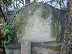
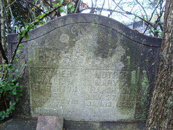
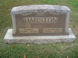
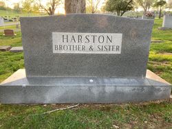
Mary Frances Lynn Harston
| Birth | : | 27 Jul 1837 |
| Death | : | 13 Jan 1929 Cedar Springs, Allen County, Kentucky, USA |
| Burial | : | Fort Bayard National Cemetery, Fort Bayard, Grant County, USA |
| Coordinate | : | 32.7989006, -108.1541977 |
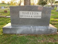
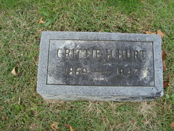
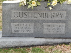
| Description | : | Mrs. Mary Harston Dies In Allen County Scottsville, Ky., Jan. 14 -- Funeral services will be held at 11 o'clock tomorrow morning for Mrs. Mary Harston, who died at her home in Cedar Springs community of Allen County at 11 o'clock last night. She is survived by three daughters, Miss Sallie Harston, Mrs. Bettie Cushionberry and Mrs. Crit Hurst and four sons, Jake Harston, Paul Harston, Sam Harston and Jim Harston. The services will be conducted at the residence by the Rev. J. R. Turner. Burial will be in the family cemetery. Source: The Courier-Journal... Read More |
frequently asked questions (FAQ):
-
Where is Mary Frances Lynn Harston's memorial?
Mary Frances Lynn Harston's memorial is located at: Fort Bayard National Cemetery, Fort Bayard, Grant County, USA.
-
When did Mary Frances Lynn Harston death?
Mary Frances Lynn Harston death on 13 Jan 1929 in Cedar Springs, Allen County, Kentucky, USA
-
Where are the coordinates of the Mary Frances Lynn Harston's memorial?
Latitude: 32.7989006
Longitude: -108.1541977
Family Members:
Spouse
Children

Flowers:


Nearby Cemetories:
1. Fort Bayard Memorial Cemetery
Fort Bayard, Grant County, USA
Coordinate: 32.7907000, -108.1565000
2. Santa Clara Cemetery
Central, Grant County, USA
Coordinate: 32.7701920, -108.1530590
3. Vanadium Cemetery
Vanadium, Grant County, USA
Coordinate: 32.7820000, -108.1100000
4. Hanover Cemetery
Hanover, Grant County, USA
Coordinate: 32.8063000, -108.0893000
5. Bayard Cemetery
Bayard, Grant County, USA
Coordinate: 32.7403620, -108.1326270
6. Fierro Cemetery
Fierro, Grant County, USA
Coordinate: 32.8436012, -108.0755997
7. Santa Rita Cemetery #4
Santa Rita, Grant County, USA
Coordinate: 32.8137200, -108.0576200
8. Santa Rita #4
Santa Rita (Noriega y Anexo), Santa Bárbara Municipality, Mexico
Coordinate: 32.8136425, -108.0571579
9. Pinos Altos Community Cemetery
Pinos Altos, Grant County, USA
Coordinate: 32.8672791, -108.2173004
10. Memory Lane Cemetery
Silver City, Grant County, USA
Coordinate: 32.7830000, -108.2570000
11. Hurley Cemetery
Hurley, Grant County, USA
Coordinate: 32.6885986, -108.1363983
12. Masonic Cemetery
Silver City, Grant County, USA
Coordinate: 32.7572972, -108.2812361
13. Saint Vincent de Paul Catholic Cemetery
Silver City, Grant County, USA
Coordinate: 32.7572861, -108.2812361
14. Georgetown Cemetery
Silver City, Grant County, USA
Coordinate: 32.8405991, -108.0147018
15. Peace of the Wilderness Cemetery
Silver City, Grant County, USA
Coordinate: 32.8682050, -108.2875500
16. Hicks Cemetery
Grant County, USA
Coordinate: 32.9103012, -108.0044022
17. San Lorenzo Cemetery
San Lorenzo, Grant County, USA
Coordinate: 32.7910270, -107.9205040
18. San Juan Catholic Cemetery
Grant County, USA
Coordinate: 32.7647705, -107.9098969
19. Pine Cienega Cemetery
Grant County, USA
Coordinate: 32.6226050, -108.3039090
20. Perrault Ranch Cemetery
Sherman, Grant County, USA
Coordinate: 32.7493770, -107.8935000
21. Savannah Cemetery
Tyrone, Grant County, USA
Coordinate: 32.6443000, -108.3568000
22. Coleson's Crossing Cemetery
Dwyer, Grant County, USA
Coordinate: 32.5682540, -107.9522090
23. Dwyer Cemetery
Dwyer, Grant County, USA
Coordinate: 32.6231600, -107.8792400
24. Foster Cemetery
Luna County, USA
Coordinate: 32.5862410, -107.9062660