| Birth | : | 6 Apr 1923 De Smet Township, Kingsbury County, South Dakota, USA |
| Death | : | 19 Jun 2002 Stockton, San Joaquin County, California, USA |
| Burial | : | Sunset View Cemetery, Martell, Amador County, USA |
| Coordinate | : | 38.3534390, -120.8328030 |
| Plot | : | Garden of Valor Statue Masoleum |
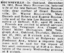
| Description | : | Mary Jeanne Daniels, 79, of Lockeford died Wednesday, June 19, 2002, in a Stockton hospital. Daniels was born April 6, 1923, in De Smet, S.D. She lived in Danville from 1951 to 1997 before moving to Lockeford. Daniels was the owner of Danville Saddlery from 1968 to 1975. She also was a Realtor with Red Carpet Realty in San Ramon. Survivors: husband, Lloyd Daniels of Lockeford; daughters, Patricia Smith of Galt, Kathy Suesens of Herald and Tracey Daniels of Manteca; and two grandchildren. Services: private. Committal: Sunset View Cemetery, Jackson. Mortuary: Daneri Mortuary. Stockton Record June 22,... Read More |
frequently asked questions (FAQ):
-
Where is Mary Jeanne Rounseville Daniels's memorial?
Mary Jeanne Rounseville Daniels's memorial is located at: Sunset View Cemetery, Martell, Amador County, USA.
-
When did Mary Jeanne Rounseville Daniels death?
Mary Jeanne Rounseville Daniels death on 19 Jun 2002 in Stockton, San Joaquin County, California, USA
-
Where are the coordinates of the Mary Jeanne Rounseville Daniels's memorial?
Latitude: 38.3534390
Longitude: -120.8328030
Family Members:
Parent
Spouse
Siblings
Flowers:
Nearby Cemetories:
1. Saint Sava Serbian Orthodox Cemetery
Jackson, Amador County, USA
Coordinate: 38.3560530, -120.7764530
2. Sutter Creek Catholic Cemetery
Sutter Creek, Amador County, USA
Coordinate: 38.3955780, -120.8101970
3. Saint Patrick Catholic Cemetery
Jackson, Amador County, USA
Coordinate: 38.3534780, -120.7742350
4. Sutter Creek City Cemetery
Sutter Creek, Amador County, USA
Coordinate: 38.3957520, -120.8091940
5. Odd Fellows Cemetery
Sutter Creek, Amador County, USA
Coordinate: 38.3964120, -120.8110550
6. Jackson Gate Perano Cemetery
Jackson, Amador County, USA
Coordinate: 38.3701640, -120.7778150
7. Amador County Museum
Jackson, Amador County, USA
Coordinate: 38.3507000, -120.7733900
8. Jackson City Cemetery
Jackson, Amador County, USA
Coordinate: 38.3519640, -120.7731340
9. Immaculate Conception Parish Cemetery
Sutter Creek, Amador County, USA
Coordinate: 38.3956980, -120.8063430
10. Pioneer Jewish Cemetery
Jackson, Amador County, USA
Coordinate: 38.3539790, -120.7724540
11. Chinese Cemetery
Jackson, Amador County, USA
Coordinate: 38.3674680, -120.7655440
12. Amador City Cemetery
Amador City, Amador County, USA
Coordinate: 38.4198000, -120.8252000
13. Oak Knoll Cemetery
Amador City, Amador County, USA
Coordinate: 38.4263992, -120.8300018
14. Ione Public Cemetery
Ione, Amador County, USA
Coordinate: 38.3478830, -120.9322000
15. Ione Catholic Cemetery
Ione, Amador County, USA
Coordinate: 38.3483040, -120.9329300
16. Preston School of Industry Cemetery
Ione, Amador County, USA
Coordinate: 38.3608440, -120.9371870
17. Parsons Plot
New Chicago, Amador County, USA
Coordinate: 38.4354000, -120.8174100
18. Drytown City Cemetery
Amador County, USA
Coordinate: 38.4407425, -120.8577118
19. Saint Stephens Cemetery
Drytown, Amador County, USA
Coordinate: 38.4417730, -120.8522840
20. Tolopiyu Cemetery
Ione, Amador County, USA
Coordinate: 38.3186300, -120.9410800
21. Buena Vista Rancheria Indian Cemetery
Ione, Amador County, USA
Coordinate: 38.2731600, -120.9107900
22. Pioneer Jewish Cemetery
Mokelumne Hill, Calaveras County, USA
Coordinate: 38.3034096, -120.7138214
23. Gardner Delles Family Cemetery
Amador County, USA
Coordinate: 38.4557700, -120.7881900
24. Mokelumne Hill Protestant Cemetery
Mokelumne Hill, Calaveras County, USA
Coordinate: 38.3023640, -120.7096420


