
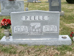
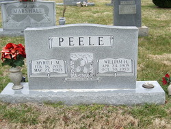
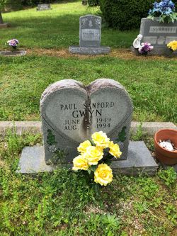
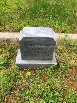
Mary Lee Myrtle McMillian Peele
| Birth | : | 18 Feb 1920 Carroll County, Virginia, USA |
| Death | : | 23 May 2003 Henry County, Virginia, USA |
| Burial | : | Holy Trinity Churchyard, Loddon, South Norfolk District, England |
| Coordinate | : | 52.5350430, 1.4832560 |
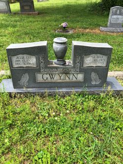
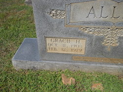
| Description | : | Myrtle Lee Gwynn Peel, 83, of 9645 Fairystone Hwy., Bassett, widow of William Howard Peele, died May 23, 2003, at the Stanleytown Health Care in Bassett. Peel was born in Carroll County, to the late Jesse Gwynn and Gracie Haynes Allen. She was a homemaker and of the Baptist faith. Surviving are a daughter, Alma Dowell of Martinsville, three sons, Kenneth Peal and Clifford Peal, both of Bassett, and William Peal of Stuart; three grandchildren; three great-grandchildren; a sister, Arlene Cook of Mt. Airy, N.C.; four half-sisters, Christina Tate of Cana; Mae Easter, Julie Gwynn and... Read More |
frequently asked questions (FAQ):
-
Where is Mary Lee Myrtle McMillian Peele's memorial?
Mary Lee Myrtle McMillian Peele's memorial is located at: Holy Trinity Churchyard, Loddon, South Norfolk District, England.
-
When did Mary Lee Myrtle McMillian Peele death?
Mary Lee Myrtle McMillian Peele death on 23 May 2003 in Henry County, Virginia, USA
-
Where are the coordinates of the Mary Lee Myrtle McMillian Peele's memorial?
Latitude: 52.5350430
Longitude: 1.4832560
Family Members:
Parent
Spouse
Siblings

Flowers:


Nearby Cemetories:
1. Holy Trinity Churchyard
Loddon, South Norfolk District, England
Coordinate: 52.5350430, 1.4832560
2. All Saints Churchyard
Chedgrave, South Norfolk District, England
Coordinate: 52.5409130, 1.4831200
3. St Gregory Churchyard
Heckingham, South Norfolk District, England
Coordinate: 52.5350940, 1.5144710
4. St. Michaels's Church Cemetery
Langley with Hardley, South Norfolk District, England
Coordinate: 52.5552220, 1.4727530
5. Hardley Methodist Chapel
Langley with Hardley, South Norfolk District, England
Coordinate: 52.5577290, 1.4957960
6. St Margaret's Churchyard
Hardley Street, South Norfolk District, England
Coordinate: 52.5522980, 1.5170630
7. St Margaret Churchyard
Hales, South Norfolk District, England
Coordinate: 52.5109380, 1.5110840
8. St Peter's Churchyard
Mundham, South Norfolk District, England
Coordinate: 52.5303890, 1.4260120
9. Langley Abbey
Langley with Hardley, South Norfolk District, England
Coordinate: 52.5719000, 1.4875700
10. St Andrews Churchyard
Raveningham, South Norfolk District, England
Coordinate: 52.5126430, 1.5323570
11. St Peter's Churchyard
Carleton St Peter, South Norfolk District, England
Coordinate: 52.5680520, 1.4514100
12. St Margaret and St Remigius Churchyard
Seething, South Norfolk District, England
Coordinate: 52.5303390, 1.4185000
13. Ss Mary and Margaret Churchyard
Norton Subcourse, North Norfolk District, England
Coordinate: 52.5324780, 1.5483860
14. All Saints Churchyard
Kirby Cane, South Norfolk District, England
Coordinate: 52.4937500, 1.4952820
15. St Mary's Parish Churchyard
Ashby St Mary, South Norfolk District, England
Coordinate: 52.5679100, 1.4354760
16. Methodist Churchyard
Norton Subcourse, North Norfolk District, England
Coordinate: 52.5317630, 1.5557020
17. St. Peter and St. Paul Churchyard
Bergh Apton, South Norfolk District, England
Coordinate: 52.5480290, 1.4060870
18. St. Margaret Churchyard
Cantley, Broadland District, England
Coordinate: 52.5826600, 1.5137200
19. St Andrews
Claxton, South Norfolk District, England
Coordinate: 52.5769660, 1.4340060
20. St Michael's Churchyard
Broome, South Norfolk District, England
Coordinate: 52.4860360, 1.4547410
21. St. Botolph's Churchyard
Limpenhoe, Broadland District, England
Coordinate: 52.5811500, 1.5340800
22. St. John the Baptist Churchyard
Hellington, South Norfolk District, England
Coordinate: 52.5761440, 1.4132050
23. St Margaret's Churchyard
Kirstead, South Norfolk District, England
Coordinate: 52.5358860, 1.3840860
24. St Mary's Churchyard
Ellingham, South Norfolk District, England
Coordinate: 52.4739393, 1.4827976