
| Birth | : | 22 Oct 1922 Redfield, Spink County, South Dakota, USA |
| Death | : | 14 Oct 2014 Sturgis, Meade County, South Dakota, USA |
| Burial | : | Scotty Philip Cemetery, Fort Pierre, Stanley County, USA |
| Coordinate | : | 44.4019012, -100.4036026 |
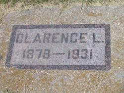
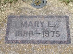
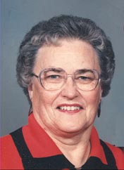
| Description | : | Mary “Lorraine” Grant, 91, Whitewood, died Tuesday, October 14, 2014, at Sturgis Regional Senior Care. Funeral services will be held Friday, October 17, 2014, at 11:30 a.m. at the First United Methodist Church in Sturgis with Pastor Jenene Earl officiating. Visitation will be one hour prior to the service at the church on Friday. Lorraine was born October 22, 1922, in Redfield, SD,she was the daughter of Clarence Leslie and Mary Ellen (Hahn) Mannings. She received her education in the Redfield schools. After graduating from Redfield High School in 1940, she worked as a clerk in the Ben Franklin Store and... Read More |
frequently asked questions (FAQ):
-
Where is Mary “Lorraine” Mannings Grant's memorial?
Mary “Lorraine” Mannings Grant's memorial is located at: Scotty Philip Cemetery, Fort Pierre, Stanley County, USA.
-
When did Mary “Lorraine” Mannings Grant death?
Mary “Lorraine” Mannings Grant death on 14 Oct 2014 in Sturgis, Meade County, South Dakota, USA
-
Where are the coordinates of the Mary “Lorraine” Mannings Grant's memorial?
Latitude: 44.4019012
Longitude: -100.4036026
Family Members:
Parent
Spouse

Siblings
Children
Flowers:


Nearby Cemetories:
1. Scotty Philip Cemetery
Fort Pierre, Stanley County, USA
Coordinate: 44.4019012, -100.4036026
2. Fort Pierre Chouteau Cemetery
Fort Pierre, Stanley County, USA
Coordinate: 44.3908700, -100.3878300
3. Mount Calvary Cemetery
Pierre, Hughes County, USA
Coordinate: 44.4197006, -100.3557968
4. South Dakota State Capitol Grounds
Pierre, Hughes County, USA
Coordinate: 44.3660100, -100.3448000
5. Cedar Hill Cemetery
Fort Pierre, Stanley County, USA
Coordinate: 44.3356018, -100.3964005
6. Riverside Cemetery
Pierre, Hughes County, USA
Coordinate: 44.3608017, -100.3071976
7. Byron Township Cemetery
Blunt, Hughes County, USA
Coordinate: 44.4979200, -100.1904700
8. Fort Sully Post Cemetery
Sully County, USA
Coordinate: 44.5866480, -100.6087530
9. Meers Cemetery
Stanley County, USA
Coordinate: 44.4116970, -100.7360760
10. Mathews Family Cemetery
Stanley County, USA
Coordinate: 44.1816040, -100.5581080
11. Okobojo Cemetery
Sully County, USA
Coordinate: 44.6568985, -100.3647003
12. Canning Cemetery
Hughes County, USA
Coordinate: 44.3986890, -100.0278460
13. Holy Name Episcopal Cemetery
Fort Pierre, Stanley County, USA
Coordinate: 44.2694960, -100.0357300
14. Holy Name Chapel Cemetery
Fort Pierre, Stanley County, USA
Coordinate: 44.2694292, -100.0356989
15. Pleasant Hill Cemetery
Blunt, Hughes County, USA
Coordinate: 44.5135994, -100.0156021
16. Fort Bennett Post Cemetery
Stanley County, USA
Coordinate: 44.6716500, -100.6404200
17. Immanuel Lutheran Cemetery
Van Metre, Jones County, USA
Coordinate: 44.0958800, -100.7263300
18. Mission Ridge Cemetery
Mission Ridge, Stanley County, USA
Coordinate: 44.6960983, -100.7716980
19. Onida Cemetery
Onida, Sully County, USA
Coordinate: 44.7147000, -100.0650000
20. Chapelle Cemetery
Hughes County, USA
Coordinate: 44.3025017, -99.8653030
21. Holy Faith Cemetery
Lyman County, USA
Coordinate: 44.1356010, -99.9878006
22. Blair Cemetery
Sully County, USA
Coordinate: 44.8027992, -100.4199982
23. Sansarc Cemetery
Hayes, Stanley County, USA
Coordinate: 44.5153008, -101.0342026
24. Draper Cemetery
Draper, Jones County, USA
Coordinate: 43.9322014, -100.5475006