
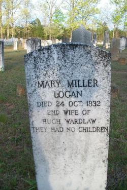
Mary Miller Logan
| Birth | : | unknown |
| Death | : | 24 Oct 1832 |
| Burial | : | Farnsworth Cemetery, Linn, Gilmer County, USA |
| Coordinate | : | 39.0177994, -80.7378006 |
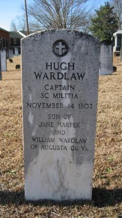
| Description | : | 2nd wife of Hugh Wardlaw They had no children according to stone inscription∼From the Genealogy of the Wardlaw Family by Joseph G. Wardlaw, pg 23: "He [Hugh Wardlaw]afterwards married Miss Mary Logan, widow _____ Logan and daughter of _______Miller.[sic] ... We find the following notice of the death of his second wife: 'Died on 24th October, 1832, in the 78th year of her age, Mrs. Mary Wardlaw, relict of Hugh Wardlaw, Esq. This lady was a member of the Presbyterian Church upwards of half a century, during which period she adorned her profession by a most consistent and exemplary conversation and... Read More |
frequently asked questions (FAQ):
-
Where is Mary Miller Logan's memorial?
Mary Miller Logan's memorial is located at: Farnsworth Cemetery, Linn, Gilmer County, USA.
-
When did Mary Miller Logan death?
Mary Miller Logan death on 24 Oct 1832 in
-
Where are the coordinates of the Mary Miller Logan's memorial?
Latitude: 39.0177994
Longitude: -80.7378006
Family Members:
Spouse
Flowers:


Nearby Cemetories:
1. Farnsworth Cemetery
Linn, Gilmer County, USA
Coordinate: 39.0177994, -80.7378006
2. Troy IOOF Community Cemetery
Troy, Gilmer County, USA
Coordinate: 39.0281170, -80.7679560
3. Rock Grove Cemetery
Latonia, Gilmer County, USA
Coordinate: 39.0125008, -80.7018967
4. Pickerel Cemetery
Baldwin, Gilmer County, USA
Coordinate: 38.9891200, -80.7289800
5. Carder Cemetery
Vadis, Lewis County, USA
Coordinate: 39.0433006, -80.7142029
6. Moneypenny Cemetery
Alum Bridge, Lewis County, USA
Coordinate: 39.0281466, -80.6809317
7. Woofter Cemetery
Alum Bridge, Lewis County, USA
Coordinate: 39.0299988, -80.6808014
8. Messenger Cemetery
Gilmer County, USA
Coordinate: 38.9714012, -80.7572021
9. Hiney Hill Cemetery
Linn, Gilmer County, USA
Coordinate: 38.9676950, -80.7405600
10. Old Field Fork Cemetery
Lewis County, USA
Coordinate: 38.9827995, -80.6710968
11. Hurst Cemetery
Lewis County, USA
Coordinate: 39.0741997, -80.6999969
12. Big Run Cemetery
Gilmer County, USA
Coordinate: 39.0802994, -80.7585983
13. Keister Cemetery
Gilmer County, USA
Coordinate: 39.0727997, -80.7817001
14. Leading Creek Baptist Church Cemetery
Alice, Gilmer County, USA
Coordinate: 38.9969000, -80.8183700
15. Keith Cemetery
Gilmer County, USA
Coordinate: 38.9561005, -80.6986008
16. Halderman Cemetery
Lewis County, USA
Coordinate: 39.0821991, -80.7039032
17. Snyder Cemetery Stewarts Creek
Glenville, Gilmer County, USA
Coordinate: 38.9577800, -80.7836100
18. Mount Earnest Cemetery
Gilmer County, USA
Coordinate: 39.0867004, -80.7652969
19. Walnut Fork Cemetery
Lewis County, USA
Coordinate: 39.0706910, -80.6644980
20. Straight Run Cemetery
Hurst, Lewis County, USA
Coordinate: 39.0802994, -80.6774979
21. Conrad Cemetery
Sand Fork, Gilmer County, USA
Coordinate: 38.9364014, -80.7296982
22. Schoonover-Dawson Cemetery
Donlan, Gilmer County, USA
Coordinate: 38.9461770, -80.6854790
23. Boilon Cemetery
Gilmer County, USA
Coordinate: 38.9519005, -80.6718979
24. McHenry Cemetery #1
Sand Fork, Gilmer County, USA
Coordinate: 38.9353310, -80.7162630