
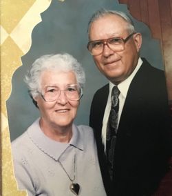

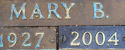
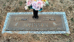
Mary Omega “Mickey” Bessinger Johnson
| Birth | : | 17 Apr 1927 Orangeburg County, South Carolina, USA |
| Death | : | 11 Mar 2004 Orangeburg, Orangeburg County, South Carolina, USA |
| Burial | : | St. Mary the Virgin Cemetery, Ipsden, South Oxfordshire District, England |
| Coordinate | : | 51.5674164, -1.0866686 |
| Description | : | Cordova - Mrs. Mary B. 'Mickey' Johnson, 76, of 124 Jon Jon Drive, Cordova, died Thursday, March 11, 2004, at The Regional Medical Center in Orangeburg. Funeral services will be at 3 p.m., Sunday, March 14, at Rivelon Baptist Church in Orangeburg with the Rev. Larry Williams and the Rev. Tant Ehrhardt officiating. Burial will be in Crestlawn Memorial Gardens in Orangeburg. Pallbearers will be Jimmy Johnson, Jerry Johnson, Andy Johnson, Shawn Boltin, Spencer Irick, and Rodney Thames. Honorary pallbearers will be Johnny Irick, Larry Gilbert, Maurice Gilbert, Ronnie Irick and members of the Adult Sunday School Class. The casket... Read More |
frequently asked questions (FAQ):
-
Where is Mary Omega “Mickey” Bessinger Johnson's memorial?
Mary Omega “Mickey” Bessinger Johnson's memorial is located at: St. Mary the Virgin Cemetery, Ipsden, South Oxfordshire District, England.
-
When did Mary Omega “Mickey” Bessinger Johnson death?
Mary Omega “Mickey” Bessinger Johnson death on 11 Mar 2004 in Orangeburg, Orangeburg County, South Carolina, USA
-
Where are the coordinates of the Mary Omega “Mickey” Bessinger Johnson's memorial?
Latitude: 51.5674164
Longitude: -1.0866686
Family Members:
Parent

Spouse
Siblings
Children

Flowers:


Nearby Cemetories:
1. St. Mary the Virgin Cemetery
Ipsden, South Oxfordshire District, England
Coordinate: 51.5674164, -1.0866686
2. St. Mary's Churchyard
North Stoke, South Oxfordshire District, England
Coordinate: 51.5714910, -1.1228080
3. St. John the Baptist Church (Defunct)
Mongwell, South Oxfordshire District, England
Coordinate: 51.5860980, -1.1233580
4. Holy Trinity Churchyard
Nuffield, South Oxfordshire District, England
Coordinate: 51.5810040, -1.0378960
5. St. Leonard's Churchyard
Woodcote, South Oxfordshire District, England
Coordinate: 51.5348117, -1.0731299
6. Checkendon Churchyard
Checkendon, South Oxfordshire District, England
Coordinate: 51.5424461, -1.0449720
7. St Mary Magdalene Churchyard
Crowmarsh Gifford, South Oxfordshire District, England
Coordinate: 51.5992169, -1.1139564
8. St Andrew Churchyard
South Stoke, South Oxfordshire District, England
Coordinate: 51.5479065, -1.1377167
9. St. Leonard's Churchyard
Wallingford, South Oxfordshire District, England
Coordinate: 51.5972711, -1.1230712
10. Saint Peter's Churchyard
Wallingford, South Oxfordshire District, England
Coordinate: 51.6005819, -1.1215970
11. St. Mary-le-More Churchyard
Wallingford, South Oxfordshire District, England
Coordinate: 51.5993878, -1.1249488
12. St John the Baptist
Moulsford, South Oxfordshire District, England
Coordinate: 51.5531050, -1.1482640
13. All Hallows Graveyard
Wallingford, South Oxfordshire District, England
Coordinate: 51.6020520, -1.1242267
14. St. John the Evangalist Churchyard
Stoke Row, South Oxfordshire District, England
Coordinate: 51.5510570, -1.0226630
15. Stoke Row Independant Chapel
Stoke Row, South Oxfordshire District, England
Coordinate: 51.5510570, -1.0226630
16. Stoke Row Independent Chapel Cemetery
Stoke Row, South Oxfordshire District, England
Coordinate: 51.5510570, -1.0226630
17. Wallingford Cemetery
Wallingford, South Oxfordshire District, England
Coordinate: 51.6058200, -1.1232000
18. St. Mary's Churchyard
Cholsey, South Oxfordshire District, England
Coordinate: 51.5788078, -1.1589500
19. Whitehill Burial Ground
Goring, South Oxfordshire District, England
Coordinate: 51.5214730, -1.1180180
20. St. Mary the Virgin Churchyard
Ewelme, South Oxfordshire District, England
Coordinate: 51.6177310, -1.0674850
21. St. Helen's Churchyard
Benson, South Oxfordshire District, England
Coordinate: 51.6200200, -1.1127400
22. St. Helen Churchyard Extension
Benson, South Oxfordshire District, England
Coordinate: 51.6201400, -1.1121200
23. Benson War Memorial
Benson, South Oxfordshire District, England
Coordinate: 51.6207890, -1.1108700
24. St. Thomas of Canterbury Churchyard
Goring, South Oxfordshire District, England
Coordinate: 51.5221440, -1.1399970