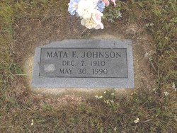
Mata Ella Schwede Johnson
| Birth | : | 7 Dec 1910 |
| Death | : | 30 May 1990 |
| Burial | : | Puerto Rico National Cemetery, Bayamon, Bayamon Municipality, USA |
| Coordinate | : | 18.4109097, -66.1693268 |
| Description | : | Mata E. Johnson, 79, Kenmare, died Wednesday, May 30, 1990, at the Americana Healthcare Center of Minot. Her funeral was held Saturday, June 2, at 11:00 a.m. at the Faith Baptist Church of Kenmare. Burial followed in the Aurelia Cemetery of rural Donnybrook at 2 p.m. Officiating for the service was Rev. Charles Taft. Organist was Pearl Nelson and vocalist was Bud Carlson. Active casketbearers included Herb Schwede, David Schwede, Bill Coons, Gary Knudtson, Mervin Gustavson, and Howard Gustavson. She was born on December 7, 1910, on the family farm near Aurelia, (near Donnybrook), a daughter of Frederick and Mary (Krueger)... Read More |
frequently asked questions (FAQ):
-
Where is Mata Ella Schwede Johnson's memorial?
Mata Ella Schwede Johnson's memorial is located at: Puerto Rico National Cemetery, Bayamon, Bayamon Municipality, USA.
-
When did Mata Ella Schwede Johnson death?
Mata Ella Schwede Johnson death on 30 May 1990 in
-
Where are the coordinates of the Mata Ella Schwede Johnson's memorial?
Latitude: 18.4109097
Longitude: -66.1693268
Family Members:
Parent
Spouse
Siblings
Flowers:
Nearby Cemetories:
1. Cementerio Porta Coeli
Hato Tejas, Bayamon Municipality, USA
Coordinate: 18.4140450, -66.1721380
2. Cementerio Municipal Braulio Dueño Colón
Bayamon, Bayamon Municipality, USA
Coordinate: 18.3929400, -66.1608700
3. Cementerio y Mausoléo Barrio Palma
Las Palmas, Catano Municipality, USA
Coordinate: 18.4358130, -66.1543280
4. Los Angeles Memorial Park
Guaynabo, Guaynabo Municipality, USA
Coordinate: 18.3963450, -66.1214500
5. Cementerio Municipal
Bay View, Catano Municipality, USA
Coordinate: 18.4439080, -66.1326360
6. Cementerio Municipal Amelia
Amelia, Guaynabo Municipality, USA
Coordinate: 18.4330540, -66.1200940
7. Cementerio Los Cipreses
Bayamon, Bayamon Municipality, USA
Coordinate: 18.3558250, -66.1783380
8. Mausoleo Municipal Cemetery
Toa Baja, Toa Baja Municipality, USA
Coordinate: 18.4265370, -66.2292400
9. Cementerio Los Hermanos Memorial Park
Toa Alta Municipality, USA
Coordinate: 18.3930683, -66.2366714
10. Cementerio Nuevo Barrio Los Frailes
Guaynabo, Guaynabo Municipality, USA
Coordinate: 18.3685590, -66.1151280
11. Catedral de San Juan Bautista
San Juan, San Juan Municipality, USA
Coordinate: 18.4656070, -66.1179690
12. Cementerio Santa María Magdalena de Pazzis
San Juan, San Juan Municipality, USA
Coordinate: 18.4692410, -66.1199200
13. San Francisco de Asis
San Juan, San Juan Municipality, USA
Coordinate: 18.4663550, -66.1134620
14. Cementerio Municipal Viejo de Toa Alta
Toa Alta, Toa Alta Municipality, USA
Coordinate: 18.3882890, -66.2512600
15. Cementerio Historico de Guaynabo
Guaynabo, Guaynabo Municipality, USA
Coordinate: 18.3489400, -66.1082400
16. Cementerio Municipal
Toa Baja, Toa Baja Municipality, USA
Coordinate: 18.4455380, -66.2548220
17. Cementerio de la Capital
Puerto Nuevo, San Juan Municipality, USA
Coordinate: 18.3842810, -66.0724590
18. Cementerio Villa Nevárez
Rio Piedras, San Juan Municipality, USA
Coordinate: 18.3924500, -66.0638900
19. Parroquia San Vicente de Paul Criptas
San Juan, San Juan Municipality, USA
Coordinate: 18.4420270, -66.0653170
20. Cementerio Municipal de Río Piedras
Rio Piedras, San Juan Municipality, USA
Coordinate: 18.4017485, -66.0528151
21. Cementerio Municipal de Dorado
Dorado, Dorado Municipality, USA
Coordinate: 18.4640400, -66.2753490
22. Cementerio San José
San Juan, San Juan Municipality, USA
Coordinate: 18.4385570, -66.0498880
23. Buxeda Memorial Park
Rio Piedras, San Juan Municipality, USA
Coordinate: 18.3755675, -66.0480496
24. El Señorial Memorial Park
San Juan, San Juan Municipality, USA
Coordinate: 18.3446200, -66.0541130

