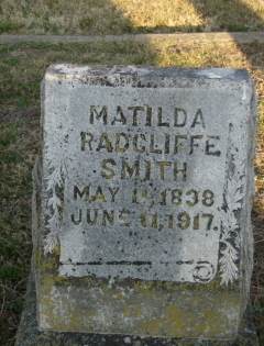
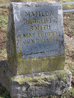
Matilda B. Radcliffe Smith
| Birth | : | 11 May 1838 Ohio, USA |
| Death | : | 11 Jun 1917 South West City, McDonald County, Missouri, USA |
| Burial | : | Sunnyside Cemetery, Long Beach, Los Angeles County, USA |
| Coordinate | : | 33.8044700, -118.1789100 |
| Description | : | Daughter of Benjamin Radcliff of Kentucky and Sarah "Sally" Florence of West Virginia. When her older sister Sarah died in Southwest City, she came to help take care of her children. She ended up becoming her brother-in-law's third wife, and she and Dr. Benjamin Franklin Smith had five children of their own. |
frequently asked questions (FAQ):
-
Where is Matilda B. Radcliffe Smith's memorial?
Matilda B. Radcliffe Smith's memorial is located at: Sunnyside Cemetery, Long Beach, Los Angeles County, USA.
-
When did Matilda B. Radcliffe Smith death?
Matilda B. Radcliffe Smith death on 11 Jun 1917 in South West City, McDonald County, Missouri, USA
-
Where are the coordinates of the Matilda B. Radcliffe Smith's memorial?
Latitude: 33.8044700
Longitude: -118.1789100
Family Members:
Parent
Spouse
Siblings
Children
Flowers:
Nearby Cemetories:
1. Long Beach Municipal Cemetery
Long Beach, Los Angeles County, USA
Coordinate: 33.8044700, -118.1769200
2. All Souls Cemetery
Long Beach, Los Angeles County, USA
Coordinate: 33.8405991, -118.1647034
3. Forest Lawn Memorial Park
Long Beach, Los Angeles County, USA
Coordinate: 33.8436012, -118.1691971
4. Palm Cemetery
Long Beach, Los Angeles County, USA
Coordinate: 33.8447200, -118.1682500
5. All Saints Anglican Church Columbarium
Long Beach, Los Angeles County, USA
Coordinate: 33.7696600, -118.1461300
6. Saint Gregory Episcopal Church Columbarium
Long Beach, Los Angeles County, USA
Coordinate: 33.8036100, -118.1105600
7. Christ Lutheran Church Columbarium
Long Beach, Los Angeles County, USA
Coordinate: 33.7952500, -118.1044100
8. Wilmington Cemetery
Wilmington, Los Angeles County, USA
Coordinate: 33.7922300, -118.2550900
9. Drum Barracks Cemetery (Defunct)
Wilmington, Los Angeles County, USA
Coordinate: 33.7855320, -118.2533170
10. Long Beach Police Academy K-9 Cemetery
Long Beach, Los Angeles County, USA
Coordinate: 33.8274000, -118.0895300
11. United States Naval Weapons Station Grounds
Seal Beach, Orange County, USA
Coordinate: 33.7505850, -118.0882970
12. Woodlawn Memorial Park
Compton, Los Angeles County, USA
Coordinate: 33.8812700, -118.2468800
13. Artesia Cemetery
Cerritos, Los Angeles County, USA
Coordinate: 33.8717003, -118.0958023
14. Angeles Abbey Memorial Park
Compton, Los Angeles County, USA
Coordinate: 33.8982887, -118.2065582
15. Lincoln Memorial Park
Carson, Los Angeles County, USA
Coordinate: 33.8806000, -118.2521973
16. Pet Haven Cemetery
Gardena, Los Angeles County, USA
Coordinate: 33.8642006, -118.2807999
17. Forest Lawn Memorial Park
Cypress, Orange County, USA
Coordinate: 33.8339005, -118.0560989
18. Downey District Cemetery
Downey, Los Angeles County, USA
Coordinate: 33.9102783, -118.1399994
19. Roosevelt Memorial Park
Gardena, Los Angeles County, USA
Coordinate: 33.8643990, -118.2947006
20. Green Hills Memorial Park
Rancho Palos Verdes, Los Angeles County, USA
Coordinate: 33.7731018, -118.3133011
21. Young Israel Cemetery
Norwalk, Los Angeles County, USA
Coordinate: 33.9071000, -118.1081300
22. Los Angeles County Farm Cemetery
Downey, Los Angeles County, USA
Coordinate: 33.9235609, -118.1694582
23. Harbor View Cemetery
San Pedro, Los Angeles County, USA
Coordinate: 33.7221240, -118.2901410
24. Gardena Buddhist Church
Gardena, Los Angeles County, USA
Coordinate: 33.8804950, -118.3023170

