
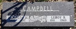
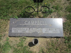
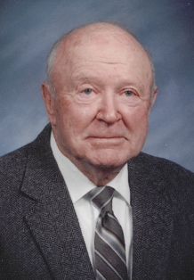
Matilda Martha Harnisch Campbell
| Birth | : | 19 Mar 1918 South Dakota, USA |
| Death | : | 15 Jun 1997 Wall, Pennington County, South Dakota, USA |
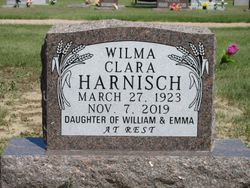
| Burial | : | Cedar Cemetery, Cedar, Smith County, USA |
| Coordinate | : | 39.6685982, -98.9310989 |
| Description | : | Name and year of birth from 1985 ground reading. Index to Obits in the Rapid City JOurnal gives the date of death as 1 June and the obit is in the Jun 3 paper? Mathilda Campbell 19 Mar 1918 15 Jun 1997 Wall, Pennington, South Dakota |
frequently asked questions (FAQ):
-
Where is Matilda Martha Harnisch Campbell's memorial?
Matilda Martha Harnisch Campbell's memorial is located at: Cedar Cemetery, Cedar, Smith County, USA.
-
When did Matilda Martha Harnisch Campbell death?
Matilda Martha Harnisch Campbell death on 15 Jun 1997 in Wall, Pennington County, South Dakota, USA
-
Where are the coordinates of the Matilda Martha Harnisch Campbell's memorial?
Latitude: 39.6685982
Longitude: -98.9310989
Family Members:
Parent
Spouse

Siblings

Flowers:


Nearby Cemetories:
1. Cedar Cemetery
Cedar, Smith County, USA
Coordinate: 39.6685982, -98.9310989
2. Saint Francis Catholic Cemetery
Cedar, Smith County, USA
Coordinate: 39.6328011, -98.9816971
3. Saint John Lutheran Cemetery
Athol, Smith County, USA
Coordinate: 39.7269900, -98.8971600
4. Christ Cemetery
Gaylord, Smith County, USA
Coordinate: 39.6988100, -98.8556700
5. Gaylord Cemetery
Gaylord, Smith County, USA
Coordinate: 39.6598300, -98.8416700
6. Leasburg Cemetery
Cedar, Smith County, USA
Coordinate: 39.5819016, -98.9728012
7. Bohemian Cemetery
Claudell, Smith County, USA
Coordinate: 39.6187800, -99.0428200
8. Olive Branch Cemetery
Kensington, Smith County, USA
Coordinate: 39.7418800, -99.0470800
9. Pleasant View Cemetery
Athol, Smith County, USA
Coordinate: 39.7859000, -98.8982000
10. Saint John Lutheran Cemetery
Kensington, Smith County, USA
Coordinate: 39.7744700, -99.0308700
11. Old Harlan Cemetery
Harlan, Smith County, USA
Coordinate: 39.6153520, -98.7632390
12. Butler Cemetery
Osborne County, USA
Coordinate: 39.5400009, -98.8494034
13. Lawrence Creek Cemetery
Portis, Osborne County, USA
Coordinate: 39.5541440, -98.8148290
14. Grant Center Cemetery
Alton, Osborne County, USA
Coordinate: 39.5242004, -98.9708023
15. Hammond Cemetery
Harlan, Smith County, USA
Coordinate: 39.5896500, -98.7479700
16. Kirwin Cemetery
Kirwin, Phillips County, USA
Coordinate: 39.6781006, -99.1421967
17. Pleasant Ridge Cemetery
Kirwin, Phillips County, USA
Coordinate: 39.5963000, -99.1234000
18. Fairview Cemetery
Smith Center, Smith County, USA
Coordinate: 39.7966995, -98.7881012
19. Bell Cemetery
Smith Center, Smith County, USA
Coordinate: 39.6477700, -98.7102200
20. Agra Cemetery
Agra, Phillips County, USA
Coordinate: 39.7571600, -99.1220400
21. Zion Cemetery
Athol, Smith County, USA
Coordinate: 39.8434100, -98.9171700
22. Garrett Cemetery
Harlan, Smith County, USA
Coordinate: 39.5873500, -98.7290900
23. Germantown Cemetery
Kensington, Smith County, USA
Coordinate: 39.8292300, -99.0450800
24. Ash Rock Cemetery
Woodston, Rooks County, USA
Coordinate: 39.5248909, -99.0817719