
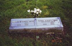
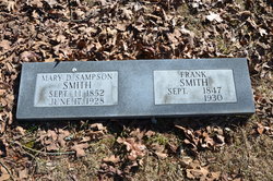
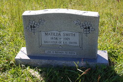
Matilda McDowell Smith
| Birth | : | 1813 |
| Death | : | 1875 |
| Burial | : | Ruggles Cemetery, Baroda, Berrien County, USA |
| Coordinate | : | 41.9644012, -86.4906006 |
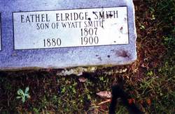
| Description | : | Wife of: Ethel Eldridge Smith Buried in Bud Smith Cemetery It is believed her father was John McDowell. Her kinship does not go to the McDowell family line of Bledsoe Co.Tn. On Bledsoe County Census, she is the only woman who's "occupation" is listed as, "Weaver". But, recent DNA Test of her gg grandchildren says: "0" Indian..... |
frequently asked questions (FAQ):
-
Where is Matilda McDowell Smith's memorial?
Matilda McDowell Smith's memorial is located at: Ruggles Cemetery, Baroda, Berrien County, USA.
-
When did Matilda McDowell Smith death?
Matilda McDowell Smith death on 1875 in
-
Where are the coordinates of the Matilda McDowell Smith's memorial?
Latitude: 41.9644012
Longitude: -86.4906006
Family Members:
Spouse
Children

Flowers:


Nearby Cemetories:
1. Ruggles Cemetery
Baroda, Berrien County, USA
Coordinate: 41.9644012, -86.4906006
2. Feather Cemetery
Hinchman, Berrien County, USA
Coordinate: 41.9720955, -86.4356689
3. Hinman Cemetery
Baroda Township, Berrien County, USA
Coordinate: 41.9272003, -86.4597015
4. Graceland Cemetery
Bridgman, Berrien County, USA
Coordinate: 41.9636002, -86.5503006
5. Salem Cemetery
Oronoko Township, Berrien County, USA
Coordinate: 41.9644012, -86.4278030
6. Greenwood Cemetery
Bridgman, Berrien County, USA
Coordinate: 41.9491997, -86.5541992
7. California School Cemetery
Lake Township, Berrien County, USA
Coordinate: 41.9205550, -86.5527770
8. Lincoln Charter Township Cemetery
Stevensville, Berrien County, USA
Coordinate: 42.0271490, -86.5139110
9. Royalton Cemetery
Saint Joseph, Berrien County, USA
Coordinate: 42.0094365, -86.4249946
10. Jerome Cemetery
Saint Joseph, Berrien County, USA
Coordinate: 42.0302699, -86.4758279
11. Boyle Cemetery
Oronoko, Berrien County, USA
Coordinate: 41.9013889, -86.4527778
12. Oak Grove Cemetery
Oronoko, Berrien County, USA
Coordinate: 41.9241982, -86.4122009
13. Hickory Bluff Cemetery
Stevensville, Berrien County, USA
Coordinate: 42.0398670, -86.4952000
14. Burke Cemetery
Berrien Springs, Berrien County, USA
Coordinate: 41.9216995, -86.3974991
15. Glendora Cemetery
Glendora, Berrien County, USA
Coordinate: 41.8786011, -86.4950027
16. Spring Run Cemetery
Scottdale, Berrien County, USA
Coordinate: 42.0407600, -86.4348526
17. Colvin Cemetery
Buchanan, Berrien County, USA
Coordinate: 41.8986110, -86.3944440
18. New Troy Cemetery
New Troy, Berrien County, USA
Coordinate: 41.8772011, -86.5578003
19. Highland Cemetery
Saint Joseph, Berrien County, USA
Coordinate: 42.0650980, -86.4987150
20. Riverview Cemetery
Saint Joseph, Berrien County, USA
Coordinate: 42.0657997, -86.4657974
21. Mount Pleasant Cemetery
Sodus Township, Berrien County, USA
Coordinate: 42.0194016, -86.3581009
22. Lett Cemetery
Sodus, Berrien County, USA
Coordinate: 42.0038890, -86.3447220
23. Rose Hill Cemetery
Berrien Springs, Berrien County, USA
Coordinate: 41.9331017, -86.3403015
24. Saint Joseph First UMC Memorial Garden
Saint Joseph, Berrien County, USA
Coordinate: 42.0810930, -86.4909620