
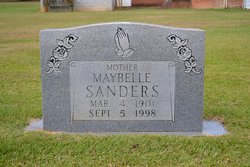
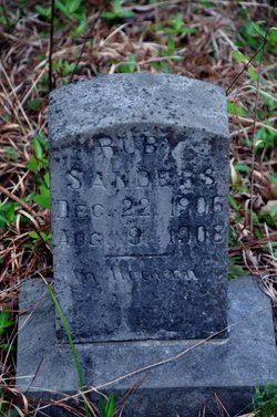
Maybelle “Polly” Sanders
| Birth | : | 4 Mar 1901 Gaffney, Cherokee County, South Carolina, USA |
| Death | : | 5 Sep 1998 Union County, South Carolina, USA |
| Burial | : | Saint Scholastica Cemetery, Fort Smith, Sebastian County, USA |
| Coordinate | : | 35.3700890, -94.3842790 |
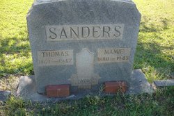
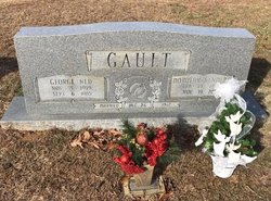
| Description | : | UNION - Maybelle "Polly" Sanders, 97, formerly of Kelton died Sept. 5, 1998, in Ellen Sagar Nursing Home after an extended illness. A native of Gaffney, she was daughter of the late Thomas Jefferson Sanders and Mamie McCullough Sanders. She was a member of Fosters Chapel United Methodist Church and a former member of the U.M.W. Survivors include a daughter, Dorothy S. Gault of Kelton; a sister, LaRue Ross of Landrum; a brother, Riley Sanders of Sharon; and two great-grandchildren. The family will receive friends from 7 to 9 tonight at S.R. Holcombe Funeral Home. Services will be held at... Read More |
frequently asked questions (FAQ):
-
Where is Maybelle “Polly” Sanders's memorial?
Maybelle “Polly” Sanders's memorial is located at: Saint Scholastica Cemetery, Fort Smith, Sebastian County, USA.
-
When did Maybelle “Polly” Sanders death?
Maybelle “Polly” Sanders death on 5 Sep 1998 in Union County, South Carolina, USA
-
Where are the coordinates of the Maybelle “Polly” Sanders's memorial?
Latitude: 35.3700890
Longitude: -94.3842790
Family Members:
Parent

Siblings

Children
Flowers:


Nearby Cemetories:
1. Saint Scholastica Cemetery
Fort Smith, Sebastian County, USA
Coordinate: 35.3700890, -94.3842790
2. Oak Cemetery
Fort Smith, Sebastian County, USA
Coordinate: 35.3694000, -94.4017029
3. Saint Bartholomew Episcopal Church Garden
Fort Smith, Sebastian County, USA
Coordinate: 35.3571380, -94.3945150
4. Christ the King Catholic Church Columbarium
Fort Smith, Sebastian County, USA
Coordinate: 35.3641970, -94.4045960
5. Goddard United Methodistb Church Columbarium
Fort Smith, Sebastian County, USA
Coordinate: 35.3720830, -94.4129730
6. Rose Lawn Park Cemetery
Fort Smith, Sebastian County, USA
Coordinate: 35.3917007, -94.3700027
7. RoseLawn Park Columbarium
Fort Smith, Sebastian County, USA
Coordinate: 35.3917000, -94.3700000
8. Calvary Cemetery
Fort Smith, Sebastian County, USA
Coordinate: 35.3764000, -94.4167023
9. Jewish Cemetery
Fort Smith, Sebastian County, USA
Coordinate: 35.3757000, -94.4176000
10. First United Methodist Church Columbarium
Fort Smith, Sebastian County, USA
Coordinate: 35.3834560, -94.4150440
11. Holy Cross Cemetery
Fort Smith, Sebastian County, USA
Coordinate: 35.3978004, -94.3685989
12. Immaculate Conception Catholic Columbarium
Fort Smith, Sebastian County, USA
Coordinate: 35.3828960, -94.4184930
13. First Presbyterian Church Columbarium
Fort Smith, Sebastian County, USA
Coordinate: 35.3849900, -94.4182700
14. Falconer Cemetery
Fort Smith, Sebastian County, USA
Coordinate: 35.3374810, -94.3939300
15. Saint John Episcopal Church Columbarium
Fort Smith, Sebastian County, USA
Coordinate: 35.3895490, -94.4234350
16. Fort Smith National Cemetery
Fort Smith, Sebastian County, USA
Coordinate: 35.3838997, -94.4291992
17. Washington Cemetery
Fort Smith, Sebastian County, USA
Coordinate: 35.4095980, -94.3713360
18. Woodlawn Memorial Park
Fort Smith, Sebastian County, USA
Coordinate: 35.3443300, -94.4329000
19. Elmwood Cemetery
Fort Smith, Sebastian County, USA
Coordinate: 35.3276430, -94.4112720
20. Stromberg Family Cemetery
Fort Smith, Sebastian County, USA
Coordinate: 35.3392160, -94.4309880
21. Forest Park Cemetery
Fort Smith, Sebastian County, USA
Coordinate: 35.4261017, -94.3719025
22. Pleasant Hill Cemetery
Sebastian County, USA
Coordinate: 35.3402140, -94.3226910
23. Nolon Springs Cemetery
Fort Smith, Sebastian County, USA
Coordinate: 35.4291992, -94.3843994
24. Crown Hill Cemetery
Van Buren, Crawford County, USA
Coordinate: 35.4337910, -94.3329620