
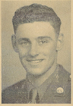

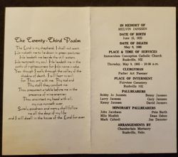
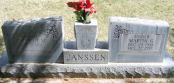
Melvin Anton Janssen
| Birth | : | 15 Jun 1922 Rushville, Sheridan County, Nebraska, USA |
| Death | : | 6 May 1985 |
| Burial | : | St. Martin's Churchyard, Bladon, West Oxfordshire District, England |
| Coordinate | : | 51.8304596, -1.3495430 |
frequently asked questions (FAQ):
-
Where is Melvin Anton Janssen's memorial?
Melvin Anton Janssen's memorial is located at: St. Martin's Churchyard, Bladon, West Oxfordshire District, England.
-
When did Melvin Anton Janssen death?
Melvin Anton Janssen death on 6 May 1985 in
-
Where are the coordinates of the Melvin Anton Janssen's memorial?
Latitude: 51.8304596
Longitude: -1.3495430
Family Members:
Parent

Spouse
Siblings
Flowers:


Nearby Cemetories:
1. St. Martin's Churchyard
Bladon, West Oxfordshire District, England
Coordinate: 51.8304596, -1.3495430
2. Blenheim Palace
Woodstock, West Oxfordshire District, England
Coordinate: 51.8414993, -1.3611000
3. St Mary Magdalene Churchyard
Woodstock, West Oxfordshire District, England
Coordinate: 51.8472890, -1.3569480
4. Hensington Road Cemetery
Woodstock, West Oxfordshire District, England
Coordinate: 51.8488700, -1.3495500
5. St. Michael's Churchyard
Begbroke, Cherwell District, England
Coordinate: 51.8221520, -1.3218069
6. Lawn Cemetery
Woodstock, West Oxfordshire District, England
Coordinate: 51.8534220, -1.3512110
7. Ss. Peter & Paul Churchyard
Church Hanborough, West Oxfordshire District, England
Coordinate: 51.8125750, -1.3838000
8. Christ Churchyard
Long Hanborough, West Oxfordshire District, England
Coordinate: 51.8247400, -1.3955000
9. Holy Cross Churchyard
Shipton-on-Cherwell, Cherwell District, England
Coordinate: 51.8452170, -1.3043260
10. St Giles Churchyard
Shipton-on-Cherwell, Cherwell District, England
Coordinate: 51.8444550, -1.2981890
11. Kidlington Burial Ground
Kidlington, Cherwell District, England
Coordinate: 51.8266010, -1.2916660
12. North Oxfordshire Memorial Park and Crematorium
Tackley, West Oxfordshire District, England
Coordinate: 51.8647410, -1.3312160
13. St Mary the Virgin Churchyard
Freeland, West Oxfordshire District, England
Coordinate: 51.8116300, -1.4004700
14. St. Bartholomew's Churchyard
Yarnton, Cherwell District, England
Coordinate: 51.8016610, -1.3087620
15. St Peter's Churchyard
Cassington, West Oxfordshire District, England
Coordinate: 51.7923610, -1.3423160
16. Yarnton Cemetery
Yarnton, Cherwell District, England
Coordinate: 51.8004080, -1.3103260
17. St Mary the Virgin Churchyard
Kidlington, Cherwell District, England
Coordinate: 51.8296680, -1.2797360
18. St Mary the Virgin Churchyard
Hampton Poyle, Cherwell District, England
Coordinate: 51.8359630, -1.2780620
19. St Mary the Virgin Churchyard
Wootton, West Oxfordshire District, England
Coordinate: 51.8756430, -1.3636990
20. Eynsham War Memorial
Eynsham, West Oxfordshire District, England
Coordinate: 51.7801562, -1.3736687
21. St Leonard Churchyard
Eynsham, West Oxfordshire District, England
Coordinate: 51.7799470, -1.3738080
22. Stonesfield Cemetery
Stonesfield, West Oxfordshire District, England
Coordinate: 51.8497110, -1.4301480
23. St. Nicholas Churchyard
Tackley, West Oxfordshire District, England
Coordinate: 51.8782400, -1.3102910
24. Saint James the Great Churchyard
Stonesfield, West Oxfordshire District, England
Coordinate: 51.8510437, -1.4303250