
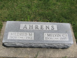
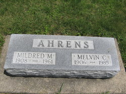
Melvin Charles Ahrens
| Birth | : | 29 May 1906 Clayton County, Iowa, USA |
| Death | : | 25 Oct 1985 Elkader, Clayton County, Iowa, USA |
| Burial | : | Woodstock Cemetery, Woodstock, Grafton County, USA |
| Coordinate | : | 43.9827600, -71.6827500 |
| Description | : | Cedar Rapids Gazette Sunday 27 Oct 1985 Volga City Melvin C. Ahrens, 79, died Friday afternoon in Central Community Hospital, Elkader. Surviving are his wife, Lorain; four daughters, Arlene Doeppke, Ivadean Doeppke and Lavon Meyers, all of Elkader, and Ellen Johansen of Cedar Rapids; two stepdaughters, Georgia Birlew of Pineville, Mo., and Jackie Quayle of Mount Pleasant; two stepsons. Forrest Zuercher of Milwaukee, Ore., and Randy Zuercher of Austin, Texas; 15 grandchildren, nine stepgrandchildren and 13 great-grandchildren. Services: 11 a.m. Monday at St. Paul Lutheran Church, Volga. Burial: East Side Cemetery, Elkader. Friends may call after 2 p.m. today at Leonard-Witt’s, Elkader, and after 10... Read More |
frequently asked questions (FAQ):
-
Where is Melvin Charles Ahrens's memorial?
Melvin Charles Ahrens's memorial is located at: Woodstock Cemetery, Woodstock, Grafton County, USA.
-
When did Melvin Charles Ahrens death?
Melvin Charles Ahrens death on 25 Oct 1985 in Elkader, Clayton County, Iowa, USA
-
Where are the coordinates of the Melvin Charles Ahrens's memorial?
Latitude: 43.9827600
Longitude: -71.6827500
Family Members:
Parent

Spouse

Flowers:


Nearby Cemetories:
1. Woodstock Cemetery
Woodstock, Grafton County, USA
Coordinate: 43.9827600, -71.6827500
2. Wildcat Cemetery
Thornton, Grafton County, USA
Coordinate: 43.9909710, -71.6391440
3. Parker Cemetery
Woodstock, Grafton County, USA
Coordinate: 44.0193000, -71.6839700
4. Jackman Cemetery
Grafton County, USA
Coordinate: 44.0322220, -71.6969440
5. Clark's Trading Post Animal Cemetery
Lincoln, Grafton County, USA
Coordinate: 44.0483740, -71.6862130
6. Riverside Cemetery
Lincoln, Grafton County, USA
Coordinate: 44.0505900, -71.6856100
7. Pine Grove Cemetery
Thornton, Grafton County, USA
Coordinate: 43.9060100, -71.6689000
8. West Thornton Cemetery
Thornton, Grafton County, USA
Coordinate: 43.8997200, -71.6805600
9. Hanson Farm Road Cemetery
Lincoln, Grafton County, USA
Coordinate: 44.0663890, -71.6869440
10. Yeaton Cemetery
Thornton, Grafton County, USA
Coordinate: 43.8963800, -71.6794500
11. Blake Mountain Cemetery
Thornton, Grafton County, USA
Coordinate: 43.8963600, -71.6794200
12. Packard Graveyard
Thornton, Grafton County, USA
Coordinate: 43.8971540, -71.5845930
13. Mad River Cemetery
Thornton, Grafton County, USA
Coordinate: 43.8833670, -71.6077500
14. Avery Cemetery
Ellsworth, Grafton County, USA
Coordinate: 43.8805600, -71.7511200
15. Pease Cemetery
Ellsworth, Grafton County, USA
Coordinate: 43.8741100, -71.7382000
16. Old Baptist Church Cemetery
Ellsworth, Grafton County, USA
Coordinate: 43.8738890, -71.7430560
17. Burbank Foss Cemetery
Campton Lower Village, Grafton County, USA
Coordinate: 43.8955730, -71.5667000
18. West Campton Cemetery
Grafton County, USA
Coordinate: 43.8622220, -71.7052780
19. Town Line Cemetery
Campton, Grafton County, USA
Coordinate: 43.8614570, -71.6678870
20. Campton Village Cemetery
Campton, Grafton County, USA
Coordinate: 43.8654440, -71.6364380
21. Waterville Valley Cemetery
Waterville Valley, Grafton County, USA
Coordinate: 43.9634670, -71.5087000
22. Blake Cemetery
Stinson Lake, Grafton County, USA
Coordinate: 43.8827780, -71.7975000
23. Partridge Hill Cemetery
West Campton, Grafton County, USA
Coordinate: 43.8428700, -71.7046900
24. Brown Farmstead Cemetery
Benton, Grafton County, USA
Coordinate: 44.0778000, -71.8420830