
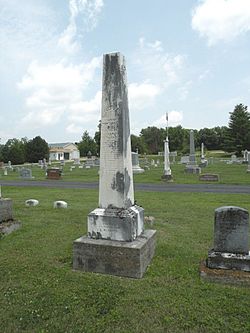
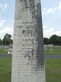
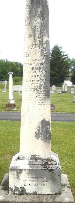
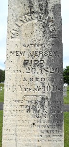
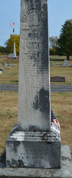

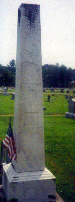
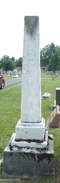
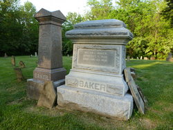
Melyn Baker
| Birth | : | 10 Jan 1760 Essex County, New Jersey, USA |
| Death | : | 20 Jan 1826 Enon, Clark County, Ohio, USA |
| Burial | : | St. Bartholomew's Churchyard, Great Harwood, Hyndburn Borough, England |
| Coordinate | : | 53.7900670, -2.4055460 |
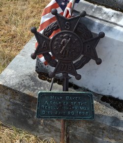
| Description | : | Married February 19, 1786 Essex County, NJ Prudence Whitehead born at Conn Farmes, NJ, son of Daniel Baker & Abigail Miller, wife Prudence Whitehead. Melyn Baker was a Veteran of the Revolutionary War. He served as a private in Captain Harriman's Company, 1st Regiment, Essex County, NJ, also in the New Jersey State Troops, enlisted for nine months in Capt. Thomas Patterson's Company, 3rd Battalion 2nd establishment; was wounded at the Battle of Monmouth on 28 June 1778. He remained in the service until the surrender of Cornwallis, and was discharged Mar 1, 1779. References: Roster... Read More |
frequently asked questions (FAQ):
-
Where is Melyn Baker's memorial?
Melyn Baker's memorial is located at: St. Bartholomew's Churchyard, Great Harwood, Hyndburn Borough, England.
-
When did Melyn Baker death?
Melyn Baker death on 20 Jan 1826 in Enon, Clark County, Ohio, USA
-
Where are the coordinates of the Melyn Baker's memorial?
Latitude: 53.7900670
Longitude: -2.4055460
Family Members:
Parent
Spouse
Siblings
Children

Flowers:


Nearby Cemetories:
1. St. Bartholomew's Churchyard
Great Harwood, Hyndburn Borough, England
Coordinate: 53.7900670, -2.4055460
2. Our Lady and Saint Hubert
Great Harwood, Hyndburn Borough, England
Coordinate: 53.7851070, -2.4009760
3. Great Harwood Cemetery
Great Harwood, Hyndburn Borough, England
Coordinate: 53.7796190, -2.4091680
4. All Saints Churchyard
Clayton-le-Moors, Hyndburn Borough, England
Coordinate: 53.7738520, -2.3881690
5. Barnes Square Weslyan Methodist Churchyard
Clayton-le-Moors, Hyndburn Borough, England
Coordinate: 53.7744350, -2.3853800
6. St Marys Burial Ground
Clayton-le-Moors, Hyndburn Borough, England
Coordinate: 53.7792778, -2.3705871
7. Church and Clayton-le-Moors Cemetery
Accrington, Hyndburn Borough, England
Coordinate: 53.7630200, -2.3804820
8. Saint Mary and All Saints Churchyard
Whalley, Ribble Valley Borough, England
Coordinate: 53.8211890, -2.4078080
9. St James Churchyard
Church, Hyndburn Borough, England
Coordinate: 53.7574640, -2.3942660
10. St. John's Churchyard
Read, Ribble Valley Borough, England
Coordinate: 53.8088800, -2.3585600
11. St James Church
Altham, Hyndburn Borough, England
Coordinate: 53.7928940, -2.3465250
12. St. Leonard Old Churchyard
Langho, Ribble Valley Borough, England
Coordinate: 53.8178590, -2.4552870
13. Whalley, Wiswell and Barrow Cemetery
Whalley, Ribble Valley Borough, England
Coordinate: 53.8308490, -2.4057280
14. Brockhall Hospital Cemetery
Brockhall Village, Ribble Valley Borough, England
Coordinate: 53.8186850, -2.4560220
15. Accrington Cemetery and Crematorium
Accrington, Hyndburn Borough, England
Coordinate: 53.7623787, -2.3508649
16. Queen Mary's Military Hospital Cemetery
Whalley, Ribble Valley Borough, England
Coordinate: 53.8337490, -2.4127930
17. Calderstones Hospital Cemetery
Whalley, Ribble Valley Borough, England
Coordinate: 53.8338710, -2.4147160
18. St. James' Parish Church
Accrington, Hyndburn Borough, England
Coordinate: 53.7519900, -2.3652600
19. Blackburn Cemetery
Blackburn, Blackburn with Darwen Unitary Authority, England
Coordinate: 53.7662430, -2.4726050
20. St Peter Churchyard
Salesbury, Ribble Valley Borough, England
Coordinate: 53.7915000, -2.4859100
21. Christ Church Churchyard
Accrington, Hyndburn Borough, England
Coordinate: 53.7478560, -2.3605820
22. St Leonard Churchyard Extension
Padiham, Burnley Borough, England
Coordinate: 53.7991800, -2.3222000
23. New Lane Baptist Chapel Chapelyard
Oswaldwistle, Hyndburn Borough, England
Coordinate: 53.7381100, -2.4049500
24. Wesleyan Methodist Chapel Chapelyard
Padiham, Burnley Borough, England
Coordinate: 53.8018980, -2.3181730