
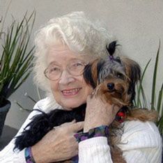
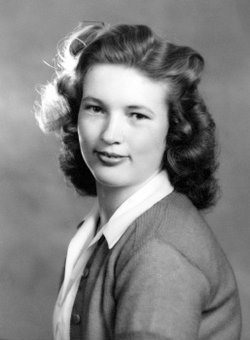
Merle Dene Mohr Markgraf
| Birth | : | 1 Sep 1922 Hooker, Tehama County, California, USA |
| Death | : | 6 Jan 2019 Oroville, Butte County, California, USA |
| Burial | : | Oak Hill Cemetery, Red Bluff, Tehama County, USA |
| Coordinate | : | 40.1699982, -122.2433014 |
| Plot | : | Garden of the Cross |
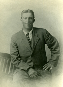
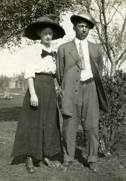
| Description | : | OBITUARY Merle Dene Markgraf 1922-2019 Our sweet, loving mother, Merle Dene (Mohr) Markgraf passed away peacefully in Oroville, CA on January 06, 2019 at age 96. She was born in Red Bluff, CA on September 1, 1922 to Mary and Albert Mohr of the Hooker District north of Red Bluff, and was a life-long native of California. Merle Dene graduated from Red Bluff Union High School in 1939, and worked for the PG&E Company in Red Bluff. She married Lowell Markgraf of the Whitmore area in 1940. The couple first lived near McCloud,... Read More |
frequently asked questions (FAQ):
-
Where is Merle Dene Mohr Markgraf's memorial?
Merle Dene Mohr Markgraf's memorial is located at: Oak Hill Cemetery, Red Bluff, Tehama County, USA.
-
When did Merle Dene Mohr Markgraf death?
Merle Dene Mohr Markgraf death on 6 Jan 2019 in Oroville, Butte County, California, USA
-
Where are the coordinates of the Merle Dene Mohr Markgraf's memorial?
Latitude: 40.1699982
Longitude: -122.2433014
Family Members:
Parent
Spouse
Siblings
Flowers:


Nearby Cemetories:
1. Red Bluff Memorial Chapel Mausoleum & Columbarium
Red Bluff, Tehama County, USA
Coordinate: 40.1717130, -122.2466860
2. Saint Mary's Cemetery
Red Bluff, Tehama County, USA
Coordinate: 40.1716995, -122.2521973
3. Growney Ranch Family Cemetery
Red Bluff, Tehama County, USA
Coordinate: 40.1167300, -122.1952500
4. Los Molinos Cemetery
Los Molinos, Tehama County, USA
Coordinate: 40.0475650, -122.1011820
5. Tehama Cemetery
Tehama, Tehama County, USA
Coordinate: 40.0233002, -122.1433029
6. Red Bank Cemetery
Red Bank, Tehama County, USA
Coordinate: 40.1036970, -122.4458540
7. Inks Creek Cemetery
Tehama County, USA
Coordinate: 40.3419800, -122.1297100
8. Cottonwood Creek Ranch Cemetery
Cottonwood, Shasta County, USA
Coordinate: 40.3663100, -122.2598800
9. Cottonwood Cemetery
Cottonwood, Shasta County, USA
Coordinate: 40.3856100, -122.2936500
10. Major Pierson B Reading Family Cemetery
Cottonwood, Shasta County, USA
Coordinate: 40.3924300, -122.2126900
11. Sunset Hill Cemetery
Corning, Tehama County, USA
Coordinate: 39.9271600, -122.1586100
12. Sleepy Hollow Pet Cemetery
Anderson, Shasta County, USA
Coordinate: 40.4199430, -122.2858410
13. Rosewood Cemetery
Rosewood, Tehama County, USA
Coordinate: 40.2685360, -122.5575190
14. New Clairvaux Abbey Cemetery
Vina, Tehama County, USA
Coordinate: 39.9381450, -122.0641890
15. Anderson District Cemetery
Anderson, Shasta County, USA
Coordinate: 40.4419518, -122.2967300
16. Oddfellows Cemetery
Anderson, Shasta County, USA
Coordinate: 40.4431590, -122.2907070
17. Anderson Pioneer Cemetery
Anderson, Shasta County, USA
Coordinate: 40.4439011, -122.2904968
18. Vina Cemetery
Vina, Tehama County, USA
Coordinate: 39.9636440, -121.9957070
19. Lowrey Cemetery
Tehama County, USA
Coordinate: 40.0066986, -122.5635986
20. Cameron-Davis Cemetery
Tehama County, USA
Coordinate: 40.2709800, -121.8778500
21. Parkville Cemetery
Anderson, Shasta County, USA
Coordinate: 40.4640200, -122.1897500
22. Lanes Valley Cemetery
Paynes Creek, Tehama County, USA
Coordinate: 40.3998400, -121.9762400
23. Pinckney Cemetery
Cottonwood, Shasta County, USA
Coordinate: 40.3997002, -122.5180969
24. Kirkwood Cemetery
Corning, Tehama County, USA
Coordinate: 39.8624992, -122.1519012