

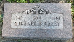
Michael Dean “Mickey” Casey
| Birth | : | 26 Jun 1949 Pottawattamie County, Iowa, USA |
| Death | : | 20 Jul 1964 Omaha, Douglas County, Nebraska, USA |
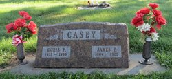
| Burial | : | Pleasant Township Cemetery, Griswold, Cass County, USA |
| Coordinate | : | 41.2056000, -95.1370000 |
| Description | : | Michael Dean Casey was born June 26, 1949 in Waveland Township, Pottawattamie County, Iowa west of Griswold, Iowa. His parents were James and Doris (Silk) Casey. Mickey was the fourth child, third son of the couple in a family that was to grow to three sons and 2 daughters. The Casey family lived on the family farm 3 miles west and 1 mile south of Griswold. Mickey was a healthy youth until the summer of 1949, when he suddenly became ill. He was diagnosed with leukemia, and died in Immanuel Lutheran Hospital in Omaha, after being a patient there for one... Read More |
frequently asked questions (FAQ):
-
Where is Michael Dean “Mickey” Casey's memorial?
Michael Dean “Mickey” Casey's memorial is located at: Pleasant Township Cemetery, Griswold, Cass County, USA.
-
When did Michael Dean “Mickey” Casey death?
Michael Dean “Mickey” Casey death on 20 Jul 1964 in Omaha, Douglas County, Nebraska, USA
-
Where are the coordinates of the Michael Dean “Mickey” Casey's memorial?
Latitude: 41.2056000
Longitude: -95.1370000
Family Members:
Parent
Siblings

Flowers:


Nearby Cemetories:
1. Pleasant Township Cemetery
Griswold, Cass County, USA
Coordinate: 41.2056000, -95.1370000
2. Mercer Cemetery
Pottawattamie County, USA
Coordinate: 41.1753006, -95.1650009
3. Griswold Cemetery
Waveland Township, Pottawattamie County, USA
Coordinate: 41.2360992, -95.1735992
4. Flint Cemetery
Pottawattamie County, USA
Coordinate: 41.2289009, -95.1841965
5. Waveland Cemetery
Pottawattamie County, USA
Coordinate: 41.1738700, -95.1881500
6. Smith Cemetery
Griswold, Cass County, USA
Coordinate: 41.2606010, -95.1453018
7. Lowman Cemetery
Griswold, Cass County, USA
Coordinate: 41.1594009, -95.0886002
8. Hillside Cemetery
Elliott, Montgomery County, USA
Coordinate: 41.1408005, -95.1544037
9. Pilot Grove Center Cemetery
Elliott, Montgomery County, USA
Coordinate: 41.1190600, -95.0993700
10. Whipple Cemetery
Pottawattamie County, USA
Coordinate: 41.2882996, -95.1983032
11. Noble Center Cemetery
Cass County, USA
Coordinate: 41.2014008, -94.9858017
12. Indian Graveyard
Sherman Township, Montgomery County, USA
Coordinate: 41.0955730, -95.1837580
13. Saint Johns UCC Cemetery
Lyman, Cass County, USA
Coordinate: 41.2160988, -94.9839020
14. Oakwood Cemetery
Lewis, Cass County, USA
Coordinate: 41.3133011, -95.0746994
15. Center Ridge Cemetery
Montgomery County, USA
Coordinate: 41.1452141, -95.2787018
16. L Laire Property Cemetery (Defunct)
Sherman Township, Montgomery County, USA
Coordinate: 41.0958257, -95.2224927
17. Grant Cemetery
Grant, Montgomery County, USA
Coordinate: 41.1405983, -94.9906006
18. Weirich Cemetery
Cass County, USA
Coordinate: 41.2146988, -94.9655991
19. Old East Cemetery
Grant, Montgomery County, USA
Coordinate: 41.1444016, -94.9792023
20. Haefflick Burial Site
Red Oak, Montgomery County, USA
Coordinate: 41.0726300, -95.1561700
21. Pilot Grove Presbyterian Cemetery
Wallin, Montgomery County, USA
Coordinate: 41.0793991, -95.0699997
22. Douglas Township Cemetery
Grant, Montgomery County, USA
Coordinate: 41.1360933, -94.9752558
23. Bradway Farm Cemetery
Macedonia, Pottawattamie County, USA
Coordinate: 41.2083300, -95.3336500
24. Wheeler Grove Cemetery
Macedonia, Pottawattamie County, USA
Coordinate: 41.2131691, -95.3393631