
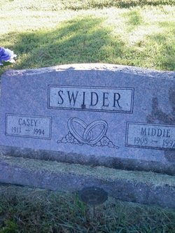
Mildred “Middie” Howe Swider
| Birth | : | 1908 |
| Death | : | 1992 |
| Burial | : | St. James' Cemetery, Bath, Bath and North East Somerset Unitary Authority, England |
| Coordinate | : | 51.3802000, -2.3722200 |
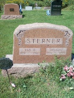
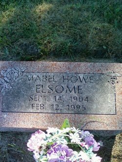
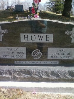
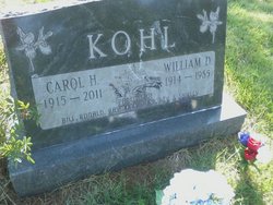
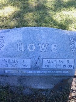
| Description | : | Mildred married Louis R. Crock 24 Nov 1927, at St. Mary's Church in Tipton, Cedar County, Iowa Cedar Rapids Gazette - Date unknown The Gazette: Tipton - Mildred Swider,83, died Friday morning in Mercy Hospital, Iowa City, after a sudden illness. Services: 1 p.m. Monday, Stanwood Union Church, Stanwood. Burial: Rochester Cemetery, Rochester. Friends may call from 4:30 to 7:30 p.m. Sunday at Chapman Funeral Home, Clarence. Survivors include her husband, Casey; a daughter, Pat Coppess of Stanwood; five sisters, Delight Sterner, Mabel Elsome and Carol Kohl, all of Tipton, Marian Coubaugh of Chicago and Martha Howe of Lincoln City, Ore.; and three... Read More |
frequently asked questions (FAQ):
-
Where is Mildred “Middie” Howe Swider's memorial?
Mildred “Middie” Howe Swider's memorial is located at: St. James' Cemetery, Bath, Bath and North East Somerset Unitary Authority, England.
-
When did Mildred “Middie” Howe Swider death?
Mildred “Middie” Howe Swider death on 1992 in
-
Where are the coordinates of the Mildred “Middie” Howe Swider's memorial?
Latitude: 51.3802000
Longitude: -2.3722200
Family Members:
Parent

Spouse

Siblings
Children

Flowers:


Nearby Cemetories:
1. St. James' Cemetery
Bath, Bath and North East Somerset Unitary Authority, England
Coordinate: 51.3802000, -2.3722200
2. St Mary's Chapel, Queens Square
Bath, Bath and North East Somerset Unitary Authority, England
Coordinate: 51.3827790, -2.3649790
3. St Mary Magdalen Chapel
Widcombe, Bath and North East Somerset Unitary Authority, England
Coordinate: 51.3760486, -2.3643405
4. St James Old Burial Ground
Bath, Bath and North East Somerset Unitary Authority, England
Coordinate: 51.3798600, -2.3610100
5. Bath General Hospital Burial Ground
Bath and North East Somerset Unitary Authority, England
Coordinate: 51.3824715, -2.3614742
6. Twerton Cemetery
Twerton, Bath and North East Somerset Unitary Authority, England
Coordinate: 51.3802500, -2.3836220
7. Quaker Meeting House
Bath, Bath and North East Somerset Unitary Authority, England
Coordinate: 51.3823280, -2.3604380
8. St. Mary de Stall Churchyard (Defunct)
Bath, Bath and North East Somerset Unitary Authority, England
Coordinate: 51.3813350, -2.3600353
9. St. Michael's Cemetery
Bath, Bath and North East Somerset Unitary Authority, England
Coordinate: 51.3859700, -2.3814500
10. Ss Michael & Paul Churchyard
Bath, Bath and North East Somerset Unitary Authority, England
Coordinate: 51.3834970, -2.3596980
11. Bath Abbey
Bath, Bath and North East Somerset Unitary Authority, England
Coordinate: 51.3815310, -2.3586640
12. St. Michael's Burial Ground
Bath, Bath and North East Somerset Unitary Authority, England
Coordinate: 51.3838810, -2.3594090
13. Old Orchard Street Catholic Burial Vault
Bath, Bath and North East Somerset Unitary Authority, England
Coordinate: 51.3800370, -2.3579910
14. Locksbrook Cemetery
Lower Weston, Bath and North East Somerset Unitary Authority, England
Coordinate: 51.3845180, -2.3850300
15. Saint Mark's Churchyard
Widcombe, Bath and North East Somerset Unitary Authority, England
Coordinate: 51.3766660, -2.3588010
16. Moravian Burial Ground
Bath, Bath and North East Somerset Unitary Authority, England
Coordinate: 51.3894150, -2.3798150
17. Baptist Burial Ground
Widcombe, Bath and North East Somerset Unitary Authority, England
Coordinate: 51.3764216, -2.3556947
18. Locksbrook St Saviour's Cemetery
Bath and North East Somerset Unitary Authority, England
Coordinate: 51.3867880, -2.3863380
19. St. Swithin Churchyard
Bath, Bath and North East Somerset Unitary Authority, England
Coordinate: 51.3885480, -2.3594500
20. Abbey & St James' Graveyard for the Poor
Widcombe, Bath and North East Somerset Unitary Authority, England
Coordinate: 51.3753550, -2.3545640
21. Old Baptist Burial Ground
Walcot, Bath and North East Somerset Unitary Authority, England
Coordinate: 51.3755070, -2.3544360
22. Walcot Methodist Chapel Burial Ground
Bath, Bath and North East Somerset Unitary Authority, England
Coordinate: 51.3897080, -2.3579610
23. St. Mary's Churchyard
Bathwick, Bath and North East Somerset Unitary Authority, England
Coordinate: 51.3876120, -2.3543540
24. St. John the Baptist Churchyard
Bathwick, Bath and North East Somerset Unitary Authority, England
Coordinate: 51.3886890, -2.3547030