


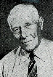
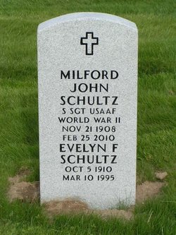
Milford John Schultz
| Birth | : | 21 Nov 1908 Alexandria, Douglas County, Minnesota, USA |
| Death | : | 25 Feb 2010 Auburn, King County, Washington, USA |
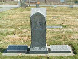
| Burial | : | Chelan Fraternal Cemetery, Chelan, Chelan County, USA |
| Coordinate | : | 47.8502998, -120.0081024 |
| Plot | : | South Fraternal Row7 STBLK8 LS8 |
| Inscription | : | S SGT USAAF - WORLD WAR II |
| Description | : | m: 19 Jan 1934 in Chelan Co, WA Milford J. Schultz, a pioneer resident of Manson passed away at 101 years. He was born Nov. 21, 1908, in Alexandria, Minn., the son of Henry and Lydia Schultz. In 1912 he and his family moved to Manson where Henry was one of the first apple orchardists in the area. Milford graduated from Manson High School and Washington State College with a degree in Manual Arts Education. He married Evelyn Weaver in January 1934 and together they owned and operated a successful photography studio business in Wenatchee. During World War II he served in the... Read More |
frequently asked questions (FAQ):
-
Where is Milford John Schultz's memorial?
Milford John Schultz's memorial is located at: Chelan Fraternal Cemetery, Chelan, Chelan County, USA.
-
When did Milford John Schultz death?
Milford John Schultz death on 25 Feb 2010 in Auburn, King County, Washington, USA
-
Where are the coordinates of the Milford John Schultz's memorial?
Latitude: 47.8502998
Longitude: -120.0081024
Family Members:
Parent
Spouse
Siblings
Flowers:


Nearby Cemetories:
1. Chelan Fraternal Cemetery
Chelan, Chelan County, USA
Coordinate: 47.8502998, -120.0081024
2. Mount Olivet Cemetery
Chelan, Chelan County, USA
Coordinate: 47.8451000, -119.9946000
3. Saint Andrews Episcopal Church
Chelan, Chelan County, USA
Coordinate: 47.8397460, -120.0183780
4. Riverview Cemetery
Chelan, Chelan County, USA
Coordinate: 47.8335991, -119.9944000
5. Manson Indian Cemetery
Manson, Chelan County, USA
Coordinate: 47.8800000, -120.1300000
6. Ballard Family Cemetery
Stayman, Chelan County, USA
Coordinate: 47.7811100, -120.1133300
7. Fletcher Cemetery
Douglas County, USA
Coordinate: 47.7430992, -119.9403000
8. Brays Landing Cemetery
Douglas County, USA
Coordinate: 47.7364120, -120.1704660
9. Kummer Cemetery
Waterville, Douglas County, USA
Coordinate: 47.6559000, -120.0332000
10. Packwood Memorial Cemetery
Dyer, Douglas County, USA
Coordinate: 48.0118305, -119.8178880
11. Dick Family Cemetery
Okanogan County, USA
Coordinate: 48.0502700, -119.9241700
12. Miller Family Cemetery
Okanogan County, USA
Coordinate: 48.0530300, -119.9288000
13. Pateros Cemetery
Pateros, Okanogan County, USA
Coordinate: 48.0516600, -119.9097300
14. Waterville Cemetery
Waterville, Douglas County, USA
Coordinate: 47.6418500, -120.0685940
15. Gate of Heaven Catholic Cemetery
Waterville, Douglas County, USA
Coordinate: 47.6382100, -120.0671690
16. Douglas Lutheran Cemetery
Douglas County, USA
Coordinate: 47.6189003, -119.9614029
17. Badger Mountain View Cemetery
Douglas County, USA
Coordinate: 47.6088000, -120.0476000
18. Mansfield Cemetery
Mansfield, Douglas County, USA
Coordinate: 47.8088880, -119.6508330
19. Orondo Community Cemetery
Orondo, Douglas County, USA
Coordinate: 47.6486015, -120.2136002
20. Buckingham Cemetery
Douglas County, USA
Coordinate: 47.8669014, -119.6286011
21. Happy Home Cemetery
Farmer, Douglas County, USA
Coordinate: 47.6268997, -119.8125000
22. Methow Cemetery
Methow, Okanogan County, USA
Coordinate: 48.1102982, -120.0124969
23. Entiat Cemetery
Entiat, Chelan County, USA
Coordinate: 47.6755981, -120.3043976
24. Bridgeport Cemetery
Bridgeport, Douglas County, USA
Coordinate: 48.0050000, -119.6738800