
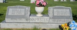
Milford William “Hap” Naprstek
| Birth | : | 3 May 1912 Farwell, Howard County, Nebraska, USA |
| Death | : | 15 May 1991 Lexington, Dawson County, Nebraska, USA |
| Burial | : | St. Cuthbert's Churchyard, Fishlake, Metropolitan Borough of Doncaster, England |
| Coordinate | : | 53.6111344, -1.0094844 |
| Plot | : | Lot 1, Blk. 31, Div. E |
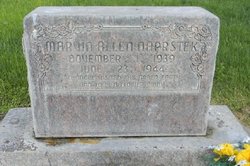
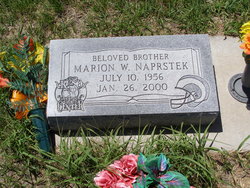
| Description | : | Researched and compiled by the Kartchner Brothers Name for Child Is Easy Choice LEXINGTON - There was no doubt in the minds of Milford and Myrtle Naprstek when their 12th child was born at the Lexington Community Hospital the baby's name should begin with the letter "M." In addition to the parents,names and the' new son, named Marion William, the first names of the couple's 11 other children begin with "M." They are Mary Ann, 21, now Mrs. Donald D. Todd of Hollywood, Calif.; Melvin Ray, 18; Marcella Mae, 15; Marilyn Kay, 14; Maxine Joyce, 11;... Read More |
frequently asked questions (FAQ):
-
Where is Milford William “Hap” Naprstek's memorial?
Milford William “Hap” Naprstek's memorial is located at: St. Cuthbert's Churchyard, Fishlake, Metropolitan Borough of Doncaster, England.
-
When did Milford William “Hap” Naprstek death?
Milford William “Hap” Naprstek death on 15 May 1991 in Lexington, Dawson County, Nebraska, USA
-
Where are the coordinates of the Milford William “Hap” Naprstek's memorial?
Latitude: 53.6111344
Longitude: -1.0094844
Family Members:
Parent

Spouse

Siblings
Children


Flowers:


Nearby Cemetories:
1. St. Cuthbert's Churchyard
Fishlake, Metropolitan Borough of Doncaster, England
Coordinate: 53.6111344, -1.0094844
2. Stainforth Cemetery
Stainforth, Metropolitan Borough of Doncaster, England
Coordinate: 53.5952800, -1.0307440
3. St. Nicholas Churchyard
Thorne, Metropolitan Borough of Doncaster, England
Coordinate: 53.6116500, -0.9580000
4. Thorne Cemetery
Thorne, Metropolitan Borough of Doncaster, England
Coordinate: 53.6084100, -0.9572000
5. St. Lawrence Churchyard
Hatfield, Metropolitan Borough of Doncaster, England
Coordinate: 53.5787230, -0.9999700
6. Hatfield Memorial Park
Hatfield, Metropolitan Borough of Doncaster, England
Coordinate: 53.5775464, -1.0013126
7. St. Mary's Churchyard
Kirk Bramwith, Metropolitan Borough of Doncaster, England
Coordinate: 53.5985711, -1.0637691
8. Hatfield Woodhouse
Hatfield, Metropolitan Borough of Doncaster, England
Coordinate: 53.5736500, -0.9855500
9. St. Wilfrith's Churchyard
Moorends, Metropolitan Borough of Doncaster, England
Coordinate: 53.6306940, -0.9502050
10. Holy Trinity Churchyard
Sykehouse, Metropolitan Borough of Doncaster, England
Coordinate: 53.6449289, -1.0492909
11. St Peter & St Paul's Churchyard
Barnby Dun, Metropolitan Borough of Doncaster, England
Coordinate: 53.5807905, -1.0737583
12. Saint Oswald's Churchyard
Kirk Sandall, Metropolitan Borough of Doncaster, England
Coordinate: 53.5665233, -1.0806768
13. St. John's Churchyard
Fenwick, Metropolitan Borough of Doncaster, England
Coordinate: 53.6284191, -1.1091576
14. All Saints Church
Moss, Metropolitan Borough of Doncaster, England
Coordinate: 53.6079090, -1.1176700
15. Rands Lane Cemetery
Armthorpe, Metropolitan Borough of Doncaster, England
Coordinate: 53.5414848, -1.0403739
16. Holy Trinity Churchyard
East Cowick, East Riding of Yorkshire Unitary Authority, England
Coordinate: 53.6866220, -1.0000200
17. St. Leonard & St. Mary Churchyard
Armthorpe, Metropolitan Borough of Doncaster, England
Coordinate: 53.5368555, -1.0633563
18. St. Peter's Churchyard
Askern, Metropolitan Borough of Doncaster, England
Coordinate: 53.6169240, -1.1524250
19. All Saints Churchyard
Arksey, Metropolitan Borough of Doncaster, England
Coordinate: 53.5557580, -1.1271520
20. Askern Cemetery
Askern, Metropolitan Borough of Doncaster, England
Coordinate: 53.6187830, -1.1637670
21. Arksey Old Cemetery
Arksey, Metropolitan Borough of Doncaster, England
Coordinate: 53.5531600, -1.1312200
22. Arksey Cemetery
Arksey, Metropolitan Borough of Doncaster, England
Coordinate: 53.5522620, -1.1312680
23. All Saints Churchyard
Owston, Metropolitan Borough of Doncaster, England
Coordinate: 53.5942161, -1.1691935
24. St Mary Churchyard
Carlton, Selby District, England
Coordinate: 53.7088060, -1.0209800