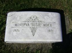
Minerva Sue “Susie” Humphreys Mock
| Birth | : | 16 Aug 1926 Clinton, Hickman County, Kentucky, USA |
| Death | : | 10 Sep 1971 Kokomo, Howard County, Indiana, USA |
| Burial | : | Penrhys Cemetery, Wales |
| Coordinate | : | 51.6420500, -3.4425800 |
frequently asked questions (FAQ):
-
Where is Minerva Sue “Susie” Humphreys Mock's memorial?
Minerva Sue “Susie” Humphreys Mock's memorial is located at: Penrhys Cemetery, Wales.
-
When did Minerva Sue “Susie” Humphreys Mock death?
Minerva Sue “Susie” Humphreys Mock death on 10 Sep 1971 in Kokomo, Howard County, Indiana, USA
-
Where are the coordinates of the Minerva Sue “Susie” Humphreys Mock's memorial?
Latitude: 51.6420500
Longitude: -3.4425800
Family Members:
Spouse
Flowers:
Nearby Cemetories:
1. Penrhys Cemetery
Wales
Coordinate: 51.6420500, -3.4425800
2. Holy Trinity Churchyard
Ilfracombe, North Devon District, England
Coordinate: 51.5571712, -3.5946496
3. Newcastle St. Illtyd Churchyard
Wales
Coordinate: 51.5080900, -3.5829600
4. St George's Churchyard
Wales
Coordinate: 51.4819300, -3.2911700
5. St Nicholas Church
Wales
Coordinate: 51.4605000, -3.3098000
6. Twyn yr Odyn Baptist Chapel Burial Ground
Wales
Coordinate: 51.4563708, -3.2739268
7. Saint David's Churchyard
Wales
Coordinate: 51.8017440, -3.6967650
8. St. Peter's Churchyard
Wales
Coordinate: 51.6133800, -3.0590490
9. St David Church Burial Ground
Wales
Coordinate: 51.7703100, -3.7884600
10. Godre'r Graig Independent Chapel Cemetery
Wales
Coordinate: 51.7474400, -3.8089300
11. Alltwen Welsh Congregational Chapelyard
Wales
Coordinate: 51.7139600, -3.8444700
12. St Elli’s Churchyard
Wales
Coordinate: 51.8264420, -3.1154820
13. Rhyd-Y-Fro Saron Congregational Old Chapelyard
Wales
Coordinate: 51.7379400, -3.8662700
14. St. Peter's Churchyard
Wales
Coordinate: 51.7364689, -2.9735286
15. St. Cadoc
Wales
Coordinate: 51.7818400, -2.9716800
16. Three Crosses Churchyard, Capel y Crwys
Wales
Coordinate: 51.6278387, -4.0653017
17. St. John the Baptist Churchyard
Weston-super-Mare, North Somerset Unitary Authority, England
Coordinate: 51.3523010, -2.9813260
18. Saint Pauls Churchyard
Kewstoke, North Somerset Unitary Authority, England
Coordinate: 51.3655500, -2.9568900
19. St Paul's Churchyard
Kewstoke, North Somerset Unitary Authority, England
Coordinate: 51.3655390, -2.9566120
20. Clevedon Cemetery
Clevedon, North Somerset Unitary Authority, England
Coordinate: 51.4322600, -2.8747270
21. St Andrew Churchyard
Clevedon, North Somerset Unitary Authority, England
Coordinate: 51.4331670, -2.8735760
22. Weston-Super-Mare Cemetery
Weston-super-Mare, North Somerset Unitary Authority, England
Coordinate: 51.3541300, -2.9676900
23. Llandingat Parish Church
Wales
Coordinate: 51.9914392, -3.8022458
24. Weston-super-Mare Emmanuel Churchyard
Weston-super-Mare, North Somerset Unitary Authority, England
Coordinate: 51.3458940, -2.9773860


