
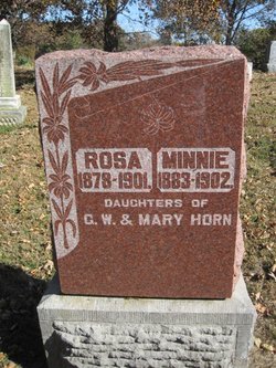
Minnie Horn
| Birth | : | 1883 |
| Death | : | 1902 |
| Burial | : | Mount Calvary Cemetery, Asheboro, Randolph County, USA |
| Coordinate | : | 35.7095920, -79.7940450 |
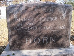
| Description | : | d/o G W and Mary |
frequently asked questions (FAQ):
-
Where is Minnie Horn's memorial?
Minnie Horn's memorial is located at: Mount Calvary Cemetery, Asheboro, Randolph County, USA.
-
When did Minnie Horn death?
Minnie Horn death on 1902 in
-
Where are the coordinates of the Minnie Horn's memorial?
Latitude: 35.7095920
Longitude: -79.7940450
Family Members:
Parent

Siblings

Flowers:


Nearby Cemetories:
1. Mount Calvary Cemetery
Asheboro, Randolph County, USA
Coordinate: 35.7095920, -79.7940450
2. Oddfellow-McAlister Cemetery
Asheboro, Randolph County, USA
Coordinate: 35.7090670, -79.7942090
3. Asheboro City Cemetery
Asheboro, Randolph County, USA
Coordinate: 35.7090000, -79.8153330
4. Allen's Temple AME Church Cemetery
Asheboro, Randolph County, USA
Coordinate: 35.7099910, -79.8238500
5. First Presbyterian Church Columbarium
Asheboro, Randolph County, USA
Coordinate: 35.6912790, -79.8196490
6. Episcopal Church of Good Shepherd Memorial Garden
Asheboro, Randolph County, USA
Coordinate: 35.7152410, -79.8327260
7. Oaklawn Cemetery
Asheboro, Randolph County, USA
Coordinate: 35.6885986, -79.8246994
8. Baileys Grove Baptist Church Cemetery
Asheboro, Randolph County, USA
Coordinate: 35.7404060, -79.8075610
9. Browers Chapel UMC Cemetery
Asheboro, Randolph County, USA
Coordinate: 35.6747290, -79.7854000
10. God Outreach Ministries Cemetery
Asheboro, Randolph County, USA
Coordinate: 35.7473240, -79.7890130
11. Giles Chapel United Methodist Church Cemetery
Asheboro, Randolph County, USA
Coordinate: 35.7462270, -79.7752450
12. West Bend United Methodist Church Cemetery
Asheboro, Randolph County, USA
Coordinate: 35.6872610, -79.8345780
13. Neighbors Grove Wesleyan Church Cemetery
Asheboro, Randolph County, USA
Coordinate: 35.7509200, -79.8045030
14. Rock Hill Primitive Baptist Cemetery
Asheboro, Randolph County, USA
Coordinate: 35.6920480, -79.8466140
15. Shady Grove Community Cemetery
Asheboro, Randolph County, USA
Coordinate: 35.7192180, -79.7287920
16. Mount Tabor Community Church Cemetery
Asheboro, Randolph County, USA
Coordinate: 35.6892900, -79.7318400
17. West Chapel United Methodist Church Cemetery
Asheboro, Randolph County, USA
Coordinate: 35.6981560, -79.8602220
18. Pleasant Cross Christian Church Cemetery
Asheboro, Randolph County, USA
Coordinate: 35.7254000, -79.7268740
19. Providence Baptist Church Cemetery
Asheboro, Randolph County, USA
Coordinate: 35.7231400, -79.7237930
20. Spoons Chapel United Church of Christ Cemetery
Asheboro, Randolph County, USA
Coordinate: 35.6763150, -79.7345110
21. Cedar Falls Baptist Church Cemetery
Cedar Falls, Randolph County, USA
Coordinate: 35.7480800, -79.7357800
22. Cedar Falls United Methodist Church Cemetery
Asheboro, Randolph County, USA
Coordinate: 35.7472920, -79.7338990
23. Liberty Road Baptist Church Cemetery
Randleman, Randolph County, USA
Coordinate: 35.7715500, -79.7808130
24. Richland Baptist Church Cemetery
Asheboro, Randolph County, USA
Coordinate: 35.6543740, -79.7559120