
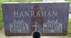

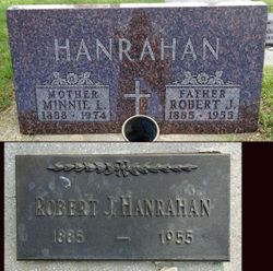
Minnie L. Crapser Hanrahan
| Birth | : | 12 May 1888 Capron, Boone County, Illinois, USA |
| Death | : | 3 Feb 1974 Philip, Haakon County, South Dakota, USA |
| Burial | : | Riverside Cemetery, Maumee, Lucas County, USA |
| Coordinate | : | 41.5491982, -83.6810989 |
| Inscription | : | Mother |
| Description | : | She moved to a farm near Brookings at the age of 10 with her father, Melvin Crapser. She later moved to Tracy, Minnesota and to Pierre. She married Robert Hanrahan in 1907 at Fort Pierre. They lived in Pierre until 1911 when they homesteaded west of Milesville. In 1955 they moved to Philip. |
frequently asked questions (FAQ):
-
Where is Minnie L. Crapser Hanrahan's memorial?
Minnie L. Crapser Hanrahan's memorial is located at: Riverside Cemetery, Maumee, Lucas County, USA.
-
When did Minnie L. Crapser Hanrahan death?
Minnie L. Crapser Hanrahan death on 3 Feb 1974 in Philip, Haakon County, South Dakota, USA
-
Where are the coordinates of the Minnie L. Crapser Hanrahan's memorial?
Latitude: 41.5491982
Longitude: -83.6810989
Family Members:
Parent

Spouse
Siblings
Children
Flowers:


Nearby Cemetories:
1. Riverside Cemetery
Maumee, Lucas County, USA
Coordinate: 41.5491982, -83.6810989
2. Fallen Timbers Battlefield Memorial Park
Monclova Township, Lucas County, USA
Coordinate: 41.5541972, -83.6899056
3. Saint Joseph Cemetery
Maumee, Lucas County, USA
Coordinate: 41.5578003, -83.6706009
4. Fort Meigs State Memorial
Perrysburg, Wood County, USA
Coordinate: 41.5496380, -83.6517710
5. First Presbyterian Church Memorial Garden
Maumee, Lucas County, USA
Coordinate: 41.5617060, -83.6500830
6. Saint Pauls Episcopal Church Memorial Garden
Maumee, Lucas County, USA
Coordinate: 41.5633830, -83.6496470
7. Karnik Memorial Garden Pet Cemetery
Waterville, Lucas County, USA
Coordinate: 41.5435980, -83.7174500
8. Fort Meigs Cemetery
Perrysburg, Wood County, USA
Coordinate: 41.5517006, -83.6402969
9. Swan Creek Cemetery
Monclova, Lucas County, USA
Coordinate: 41.5738983, -83.7089005
10. Lyon Cemetery
Perrysburg, Wood County, USA
Coordinate: 41.5205200, -83.7035500
11. Heffelbower Cemetery
Lucas County, USA
Coordinate: 41.5534248, -83.7308426
12. Saint Mary Mother of Sorrows Cemetery
Roachton, Wood County, USA
Coordinate: 41.5075970, -83.6607170
13. Zoar Lutheran Memorial Garden
Perrysburg, Wood County, USA
Coordinate: 41.5585480, -83.6228730
14. Old Perrysburg Township Cemetery
Perrysburg, Wood County, USA
Coordinate: 41.5595820, -83.6214290
15. Saint Rose Cemetery
Perrysburg, Wood County, USA
Coordinate: 41.5633011, -83.6149979
16. Allen-Lloyd Cemetery
Monclova Township, Lucas County, USA
Coordinate: 41.5415130, -83.7492190
17. Saint Timothys Episcopal Church Memorial Garden
Perrysburg, Wood County, USA
Coordinate: 41.5558000, -83.6115300
18. Roth Cemetery
Monclova, Lucas County, USA
Coordinate: 41.5549270, -83.7526420
19. Burchfield Cemetery
Springfield Township, Lucas County, USA
Coordinate: 41.5951170, -83.7190140
20. Holloway Cemetery (Defunct)
Springfield Township, Lucas County, USA
Coordinate: 41.5964900, -83.7208270
21. Wakeman Cemetery
Waterville, Lucas County, USA
Coordinate: 41.4978300, -83.7263300
22. Miltonville Cemetery
Haskins, Wood County, USA
Coordinate: 41.4853400, -83.7162500
23. Springfield Township Cemetery
Holland, Lucas County, USA
Coordinate: 41.6110992, -83.7230988
24. Hufford Cemetery
Perrysburg, Wood County, USA
Coordinate: 41.5649986, -83.5896988