
| Birth | : | 7 Oct 1872 Wapello County, Iowa, USA |
| Death | : | 24 Feb 1949 Council Bluffs, Pottawattamie County, Iowa, USA |
| Burial | : | Fort Custer National Cemetery, Augusta, Kalamazoo County, USA |
| Coordinate | : | 42.3384514, -85.3191986 |
| Plot | : | Block 3, plot 84 |
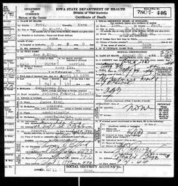
| Description | : | Minnie M. (King) is the daughter of Hannah E. (Warren) & James K. Polk King. Minnie married first Ira O. Jennings in 1888. They had 5 children. Ira Jennings died in 1911. Minnie married the widower, Charles Clark Deahl on 26 Nov 1911 * * * * * * * * * * * * * * * Published in the Ottumwa Courier Friday 25 February 1949 page 12, column 6 &7 Mrs. Minnie M. Deahl Word has been received of the death in Edmundson hospital, Council Bluffs, of Mrs. Minnie M. Deahl, 72, formerly of Ottumwa. Mrs. Deahl had been making her home... Read More |
frequently asked questions (FAQ):
-
Where is Minnie M King Deahl's memorial?
Minnie M King Deahl's memorial is located at: Fort Custer National Cemetery, Augusta, Kalamazoo County, USA.
-
When did Minnie M King Deahl death?
Minnie M King Deahl death on 24 Feb 1949 in Council Bluffs, Pottawattamie County, Iowa, USA
-
Where are the coordinates of the Minnie M King Deahl's memorial?
Latitude: 42.3384514
Longitude: -85.3191986
Family Members:
Parent

Spouse
Siblings
Children
Flowers:


Nearby Cemetories:
1. Fort Custer National Cemetery
Augusta, Kalamazoo County, USA
Coordinate: 42.3384514, -85.3191986
2. Augusta Cemetery
Augusta, Kalamazoo County, USA
Coordinate: 42.3392240, -85.3566830
3. Harmonia Cemetery
Bedford, Calhoun County, USA
Coordinate: 42.3436012, -85.2782974
4. Lawler Cemetery
Augusta, Kalamazoo County, USA
Coordinate: 42.3050003, -85.3469009
5. Ross Center Cemetery
Augusta, Kalamazoo County, USA
Coordinate: 42.3760986, -85.3619003
6. Day Cemetery
Augusta, Kalamazoo County, USA
Coordinate: 42.3905983, -85.3285980
7. Howlandsburg Cemetery
Ross Township, Kalamazoo County, USA
Coordinate: 42.3344002, -85.3961029
8. Reese Cemetery
Springfield, Calhoun County, USA
Coordinate: 42.3196983, -85.2375031
9. Memorial Park Sunset Gardens
Battle Creek, Calhoun County, USA
Coordinate: 42.3010950, -85.2393690
10. Youngs Cemetery
Battle Creek, Calhoun County, USA
Coordinate: 42.3031693, -85.2358398
11. Memorial Park Cemetery
Battle Creek, Calhoun County, USA
Coordinate: 42.3005981, -85.2358017
12. Yorkville Cemetery
Yorkville, Kalamazoo County, USA
Coordinate: 42.3773190, -85.4048660
13. Oak Grove Cemetery
Galesburg, Kalamazoo County, USA
Coordinate: 42.3008003, -85.4152985
14. Haskell Home Cemetery
Battle Creek, Calhoun County, USA
Coordinate: 42.3350590, -85.2093310
15. Riverside Cemetery
Galesburg, Kalamazoo County, USA
Coordinate: 42.2831001, -85.4011002
16. Harmon Halladay Cemetery
Bedford, Calhoun County, USA
Coordinate: 42.3546982, -85.2061005
17. Roof Cemetery
Climax, Kalamazoo County, USA
Coordinate: 42.2538986, -85.3368988
18. Bedford Cemetery
Bedford Township, Calhoun County, USA
Coordinate: 42.3938103, -85.2306671
19. Galesburg City Cemetery
Galesburg, Kalamazoo County, USA
Coordinate: 42.2925491, -85.4193878
20. Shafter Cemetery
Galesburg, Kalamazoo County, USA
Coordinate: 42.2966995, -85.4261017
21. Beckley Cemetery
Battle Creek, Calhoun County, USA
Coordinate: 42.2633018, -85.2375031
22. Toad Hollow Cemetery
Galesburg, Kalamazoo County, USA
Coordinate: 42.2541885, -85.3854828
23. Prairie Home Cemetery
Climax, Kalamazoo County, USA
Coordinate: 42.2351189, -85.3364410
24. Prairie Home Cemetery
Richland, Kalamazoo County, USA
Coordinate: 42.3760470, -85.4507590