
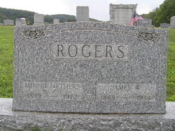
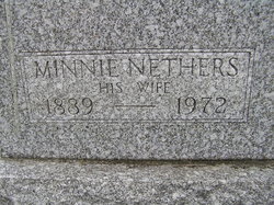
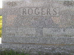
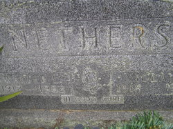
Mrs Minnie A Crawmer Nethers Rogers
| Birth | : | 30 May 1889 Toboso, Licking County, Ohio, USA |
| Death | : | 9 Jul 1972 Newark, Licking County, Ohio, USA |
| Burial | : | St Helen Churchyard, Wheldrake, York Unitary Authority, England |
| Coordinate | : | 53.8965340, -0.9626520 |
frequently asked questions (FAQ):
-
Where is Mrs Minnie A Crawmer Nethers Rogers's memorial?
Mrs Minnie A Crawmer Nethers Rogers's memorial is located at: St Helen Churchyard, Wheldrake, York Unitary Authority, England.
-
When did Mrs Minnie A Crawmer Nethers Rogers death?
Mrs Minnie A Crawmer Nethers Rogers death on 9 Jul 1972 in Newark, Licking County, Ohio, USA
-
Where are the coordinates of the Mrs Minnie A Crawmer Nethers Rogers's memorial?
Latitude: 53.8965340
Longitude: -0.9626520
Family Members:
Parent

Spouse
Siblings
Children
Flowers:


Nearby Cemetories:
1. St Helen Churchyard
Wheldrake, York Unitary Authority, England
Coordinate: 53.8965340, -0.9626520
2. Holy Trinity Churchyard
Elvington, York Unitary Authority, England
Coordinate: 53.9186950, -0.9341610
3. Quaker Cemetery
East Cottingwith, East Riding of Yorkshire Unitary Authority, England
Coordinate: 53.8746050, -0.9327040
4. St Mary Churchyard
East Cottingwith, East Riding of Yorkshire Unitary Authority, England
Coordinate: 53.8738030, -0.9317490
5. St Helen Churchyard
Thorganby, Selby District, England
Coordinate: 53.8666100, -0.9530300
6. St Mary and St Lawrence Churchyard
Ellerton, East Riding of Yorkshire Unitary Authority, England
Coordinate: 53.8499000, -0.9347520
7. St. Helen's Churchyard
Escrick, Selby District, England
Coordinate: 53.8805200, -1.0460990
8. St Paul Churchyard
Kexby, York Unitary Authority, England
Coordinate: 53.9505970, -0.9339900
9. All Saints Churchyard
Aughton, East Riding of Yorkshire Unitary Authority, England
Coordinate: 53.8393490, -0.9352200
10. St. Helen's Churchyard
Skipwith, Selby District, England
Coordinate: 53.8386300, -1.0022900
11. St Paul Churchyard
Heslington, York Unitary Authority, England
Coordinate: 53.9471780, -1.0445150
12. St Nicholas Churchyard
Dunnington, York Unitary Authority, England
Coordinate: 53.9661680, -0.9829590
13. Fulford Cemetery
Fulford, York Unitary Authority, England
Coordinate: 53.9304450, -1.0683670
14. Dunnington Cemetery
Dunnington, York Unitary Authority, England
Coordinate: 53.9675110, -0.9823760
15. Saint James Churchyard
Murton, York Unitary Authority, England
Coordinate: 53.9656390, -1.0125031
16. St Matthew Churchyard
Naburn, York Unitary Authority, England
Coordinate: 53.9009520, -1.0899200
17. St Thomas Churchyard
Osbaldwick, York Unitary Authority, England
Coordinate: 53.9588640, -1.0338800
18. Friends Burial Ground
York, York Unitary Authority, England
Coordinate: 53.9478920, -1.0618450
19. Holy Trinity Churchyard
Acaster Malbis, York Unitary Authority, England
Coordinate: 53.9052480, -1.0975170
20. St. Andrew's Old Churchyard
Bishopthorpe, York Unitary Authority, England
Coordinate: 53.9221490, -1.0929640
21. St Oswald's Old Churchyard
Fulford, York Unitary Authority, England
Coordinate: 53.9391350, -1.0809020
22. York Crematorium
York, York Unitary Authority, England
Coordinate: 53.9264970, -1.0936130
23. St Andrew Churchyard
Bishopthorpe, York Unitary Authority, England
Coordinate: 53.9236690, -1.0955320
24. Holy Trinity Churchyard
Holtby, York Unitary Authority, England
Coordinate: 53.9792890, -0.9719310