
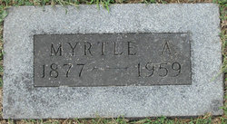
Myrtle Anna Snodgrass Renken
| Birth | : | 28 Apr 1877 Pisgah, Cooper County, Missouri, USA |
| Death | : | 15 Sep 1959 Enon, Moniteau County, Missouri, USA |
| Burial | : | Olean Cemetery, Olean, Miller County, USA |
| Coordinate | : | 38.4131012, -92.5413971 |
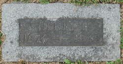
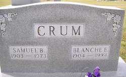
| Description | : | The Daily Capital News Jefferson City, Missouri 17 Sept 1959 Funeral services will be conducted at 2 pm today at the Olean Christian Church for Mrs. Myrtle Rankin, 82, who died at 4 pm Tuesday, at the home of her daughter, Mrs. Ray Medlin of Enon. Mrs. Rankin was born April 28, 1877, the daughter of Mr. and Mrs. William Snodgrass. In October, 1898, she was married to Henry I. Rankin, who preceded her in death along with two children. Survivors include five daughters, Mrs. W.F. Allen, Boonville, Mrs. Sam Crum, Olean, Mrs. Edward Dooley, Mt. Vernon,... Read More |
frequently asked questions (FAQ):
-
Where is Myrtle Anna Snodgrass Renken's memorial?
Myrtle Anna Snodgrass Renken's memorial is located at: Olean Cemetery, Olean, Miller County, USA.
-
When did Myrtle Anna Snodgrass Renken death?
Myrtle Anna Snodgrass Renken death on 15 Sep 1959 in Enon, Moniteau County, Missouri, USA
-
Where are the coordinates of the Myrtle Anna Snodgrass Renken's memorial?
Latitude: 38.4131012
Longitude: -92.5413971
Family Members:
Parent
Spouse
Siblings

Children
Flowers:


Nearby Cemetories:
1. Olean Cemetery
Olean, Miller County, USA
Coordinate: 38.4131012, -92.5413971
2. Green Ridge Baptist Church Cemetery
Eldon, Miller County, USA
Coordinate: 38.4116200, -92.5645700
3. Etter-Walker Cemetery
Burris Fork, Moniteau County, USA
Coordinate: 38.4333700, -92.5525400
4. Walker Cemetery
Moniteau County, USA
Coordinate: 38.4338989, -92.5522003
5. Farris Cemetery
Moniteau County, USA
Coordinate: 38.4369900, -92.5380000
6. Allen Cemetery
Olean, Miller County, USA
Coordinate: 38.4150009, -92.5008011
7. Jackson Chapel Methodist Church Cemetery
California, Moniteau County, USA
Coordinate: 38.4447900, -92.5286500
8. Gray Cemetery
Moniteau County, USA
Coordinate: 38.4536018, -92.5456009
9. Hite Cemetery
Miller County, USA
Coordinate: 38.4039001, -92.5935974
10. Mount Pleasant Cemetery
Eldon, Miller County, USA
Coordinate: 38.3667700, -92.5300800
11. Salem Cemetery
Saline Township, Miller County, USA
Coordinate: 38.3691232, -92.5697260
12. Salem Cemetery
Eldon, Miller County, USA
Coordinate: 38.3697014, -92.5714035
13. Mount Vernon Cemetery
Eldon, Miller County, USA
Coordinate: 38.3624992, -92.5606003
14. Bruce-Lewis-McGahan Cemetery
Enon, Moniteau County, USA
Coordinate: 38.4667500, -92.5172100
15. Rock Enon Cemetery
Miller County, USA
Coordinate: 38.4668400, -92.5170700
16. Eldon Cemetery
Eldon, Miller County, USA
Coordinate: 38.3642006, -92.5868988
17. Phillips Cemetery
High Point, Moniteau County, USA
Coordinate: 38.4430300, -92.6125300
18. Colburn Cemetery
Eldon, Miller County, USA
Coordinate: 38.4246300, -92.6275500
19. Depp Cemetery
High Point, Moniteau County, USA
Coordinate: 38.4776400, -92.5818500
20. High Point Cemetery
High Point, Moniteau County, USA
Coordinate: 38.4817009, -92.5757980
21. Phillips Cemetery
Barnett, Morgan County, USA
Coordinate: 38.4227982, -92.6367035
22. Matheis Cemetery
Russellville, Cole County, USA
Coordinate: 38.4571800, -92.4491600
23. United Baptist Church Cemetery
High Point, Moniteau County, USA
Coordinate: 38.4962200, -92.5856800
24. Karnes-Carney-Henderson Cemetery
Burris Fork, Moniteau County, USA
Coordinate: 38.4992100, -92.5007510