
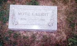
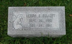
Myrtle Elizabeth Hines Elliott
| Birth | : | 24 Apr 1894 |
| Death | : | 13 Sep 1981 |
| Burial | : | All Saints Churchyard, Hoby, Melton Borough, England |
| Coordinate | : | 52.7496100, -1.0101660 |
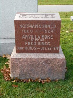
| Description | : | Myrtle Hines married John Elliott 12 Feb 1910. They had 3 daughters: Lucille, Leona and Dorothy. |
frequently asked questions (FAQ):
-
Where is Myrtle Elizabeth Hines Elliott's memorial?
Myrtle Elizabeth Hines Elliott's memorial is located at: All Saints Churchyard, Hoby, Melton Borough, England.
-
When did Myrtle Elizabeth Hines Elliott death?
Myrtle Elizabeth Hines Elliott death on 13 Sep 1981 in
-
Where are the coordinates of the Myrtle Elizabeth Hines Elliott's memorial?
Latitude: 52.7496100
Longitude: -1.0101660
Family Members:
Parent

Spouse
Siblings
Children
Flowers:


Nearby Cemetories:
1. All Saints Churchyard
Hoby, Melton Borough, England
Coordinate: 52.7496100, -1.0101660
2. All Saints Churchyard
Rotherby, Melton Borough, England
Coordinate: 52.7423100, -1.0013400
3. St Michael and All Angels Churchyard, Brooksby Hall
Melton Mowbray, Melton Borough, England
Coordinate: 52.7375450, -1.0076900
4. Frisby on the Wreake Parish Council Burial Ground
Frisby on the Wreake, Melton Borough, England
Coordinate: 52.7480480, -0.9801370
5. Holy Trinity Churchyard
Thrussington, Charnwood Borough, England
Coordinate: 52.7359030, -1.0381780
6. All Saints Church
Melton Borough, England
Coordinate: 52.7728570, -1.0209240
7. St Thomas of Canterbury Churchyard
Frisby on the Wreake, Melton Borough, England
Coordinate: 52.7531250, -0.9706940
8. All Saints Churchyard
Melton Mowbray, Melton Borough, England
Coordinate: 52.7728700, -1.0209400
9. St Thomas of Canterbury Churchyard Extension
Frisby on the Wreake, Melton Borough, England
Coordinate: 52.7537270, -0.9698390
10. St Michael and All Angels Churchyard
Rearsby, Charnwood Borough, England
Coordinate: 52.7255100, -1.0373500
11. Asfordby Loughborough Road Cemetery
Asfordby, Melton Borough, England
Coordinate: 52.7654300, -0.9626900
12. All Saints Churchyard
Asfordby, Melton Borough, England
Coordinate: 52.7635100, -0.9523300
13. Saint Luke's Churchyard
Gaddesby, Melton Borough, England
Coordinate: 52.7107200, -0.9805300
14. St Botolphs Churchyard
Ratcliffe on the Wreake, Charnwood Borough, England
Coordinate: 52.7248680, -1.0680400
15. St Peter's Churchyard
Saxelbye, Melton Borough, England
Coordinate: 52.7817900, -0.9626700
16. St John the Baptist Churchyard
Grimston, Melton Borough, England
Coordinate: 52.7902720, -0.9850350
17. All Saints Churchyard
Seagrave, Charnwood Borough, England
Coordinate: 52.7525110, -1.0829090
18. St Peter Churchyard
Kirby Bellars, Melton Borough, England
Coordinate: 52.7569830, -0.9376920
19. Ratcliffe College
Ratcliffe on the Wreake, Charnwood Borough, England
Coordinate: 52.7294430, -1.0758320
20. Seagrave Swan Street Cemetery
Seagrave, Charnwood Borough, England
Coordinate: 52.7520370, -1.0883200
21. Queniborough Cemetery
Queniborough, Charnwood Borough, England
Coordinate: 52.7011860, -1.0315250
22. St Mary Churchyard
Queniborough, Charnwood Borough, England
Coordinate: 52.7023900, -1.0382700
23. St John the Baptist Churchyard
Old Dalby, Melton Borough, England
Coordinate: 52.8053510, -1.0017970
24. Sileby Cemetery
Sileby, Charnwood Borough, England
Coordinate: 52.7299340, -1.1004210