
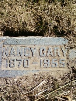
Nancy Crees Cary
| Birth | : | 1 Jan 1870 Cedar County, Iowa, USA |
| Death | : | 16 Sep 1955 Blue Island, Cook County, Illinois, USA |
| Burial | : | Napier Cemetery, Hohenwald, Lewis County, USA |
| Coordinate | : | 35.4403000, -87.4788971 |
frequently asked questions (FAQ):
-
Where is Nancy Crees Cary's memorial?
Nancy Crees Cary's memorial is located at: Napier Cemetery, Hohenwald, Lewis County, USA.
-
When did Nancy Crees Cary death?
Nancy Crees Cary death on 16 Sep 1955 in Blue Island, Cook County, Illinois, USA
-
Where are the coordinates of the Nancy Crees Cary's memorial?
Latitude: 35.4403000
Longitude: -87.4788971
Family Members:
Parent

Spouse
Siblings
Flowers:


Nearby Cemetories:
1. Napier Cemetery
Hohenwald, Lewis County, USA
Coordinate: 35.4403000, -87.4788971
2. Napier Cemetery
Lewis County, USA
Coordinate: 35.4367000, -87.4783000
3. Newtown Cemetery
Lewis County, USA
Coordinate: 35.4399986, -87.4906006
4. Pollock Cemetery
Lewis County, USA
Coordinate: 35.4672012, -87.5006027
5. Bailey Cemetery
Lewis County, USA
Coordinate: 35.4193993, -87.5152969
6. Collier Cemetery
Lewis County, USA
Coordinate: 35.4606018, -87.5171967
7. Dirtdobber Cemetery
Lewis County, USA
Coordinate: 35.4296989, -87.5327988
8. Laurel Hill Cemetery
Lawrence County, USA
Coordinate: 35.3939018, -87.5156021
9. Pope Cemetery
Lewis County, USA
Coordinate: 35.4646988, -87.5417023
10. Voorhies Cemetery
Lewis County, USA
Coordinate: 35.4413986, -87.5496979
11. Vinson Family Cemetery
Lawrenceburg, Lawrence County, USA
Coordinate: 35.3859000, -87.4542400
12. Davis Cemetery
Lewis County, USA
Coordinate: 35.4564018, -87.5483017
13. Himes Cemetery
Lewis County, USA
Coordinate: 35.4925003, -87.4443970
14. Brock Cemetery
Lawrence County, USA
Coordinate: 35.3892000, -87.4414000
15. Garland Cemetery
Lawrenceburg, Lawrence County, USA
Coordinate: 35.3763657, -87.4737473
16. Poore Cemetery
Lewis County, USA
Coordinate: 35.4874992, -87.5430984
17. Grinders Creek Cemetery
Lewis County, USA
Coordinate: 35.5099983, -87.4963989
18. Pioneer Cemetery
Hohenwald, Lewis County, USA
Coordinate: 35.5107994, -87.4606018
19. Brush Creek Cemetery
Lawrence County, USA
Coordinate: 35.3950005, -87.5531006
20. Grinders Creek Cemetery
Lewis County, USA
Coordinate: 35.4944000, -87.5438995
21. Payton Cemetery
Lewis County, USA
Coordinate: 35.4067001, -87.5653000
22. Henryville Cemetery
Henryville, Lawrence County, USA
Coordinate: 35.3955994, -87.3996964
23. Wright Cemetery
Lewis County, USA
Coordinate: 35.5208015, -87.4803009
24. Freedom Holy Temple Cemetery
Hohenwald, Lewis County, USA
Coordinate: 35.5015340, -87.5482810