

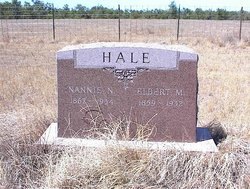
Nancy Narcissus “Nannie” McLean Hale
| Birth | : | 7 Dec 1866 Elk Creek, Grayson County, Virginia, USA |
| Death | : | 4 Jun 1934 Alzada, Carter County, Montana, USA |
| Burial | : | Accrington Cemetery and Crematorium, Accrington, Hyndburn Borough, England |
| Coordinate | : | 53.7623787, -2.3508649 |
| Description | : | Nancy M. Hale, age 67, well known lady of near Alzada, Mont., passed away Monday at her ranch home following illness of some time. Funeral services were conducted Tuesday afternoon at Alzada, Mont., by Rev. E. C. Antrim of the Methodist church of Belle Fourche, and interment made in the Alzada Cemetery. Nannie Nancy McLean was born Dec. 7, 1866 at Elk Creek, Virginia. She was united in marriage to Elbert Martin Hale on November 22, 1882. In 1885, Mr. Hale came to Wyoming and in 1886 Mrs. Hale joined him and they... Read More |
frequently asked questions (FAQ):
-
Where is Nancy Narcissus “Nannie” McLean Hale's memorial?
Nancy Narcissus “Nannie” McLean Hale's memorial is located at: Accrington Cemetery and Crematorium, Accrington, Hyndburn Borough, England.
-
When did Nancy Narcissus “Nannie” McLean Hale death?
Nancy Narcissus “Nannie” McLean Hale death on 4 Jun 1934 in Alzada, Carter County, Montana, USA
-
Where are the coordinates of the Nancy Narcissus “Nannie” McLean Hale's memorial?
Latitude: 53.7623787
Longitude: -2.3508649
Family Members:
Spouse
Children

Flowers:


Nearby Cemetories:
1. Accrington Cemetery and Crematorium
Accrington, Hyndburn Borough, England
Coordinate: 53.7623787, -2.3508649
2. St. James' Parish Church
Accrington, Hyndburn Borough, England
Coordinate: 53.7519900, -2.3652600
3. Christ Church Churchyard
Accrington, Hyndburn Borough, England
Coordinate: 53.7478560, -2.3605820
4. Church and Clayton-le-Moors Cemetery
Accrington, Hyndburn Borough, England
Coordinate: 53.7630200, -2.3804820
5. St Marys Burial Ground
Clayton-le-Moors, Hyndburn Borough, England
Coordinate: 53.7792778, -2.3705871
6. Barnes Square Weslyan Methodist Churchyard
Clayton-le-Moors, Hyndburn Borough, England
Coordinate: 53.7744350, -2.3853800
7. All Saints Churchyard
Clayton-le-Moors, Hyndburn Borough, England
Coordinate: 53.7738520, -2.3881690
8. St James Churchyard
Church, Hyndburn Borough, England
Coordinate: 53.7574640, -2.3942660
9. St Margaret Churchyard
Hapton, Burnley Borough, England
Coordinate: 53.7802400, -2.3169230
10. St. John the Baptist Churchyard
Baxenden, Hyndburn Borough, England
Coordinate: 53.7346500, -2.3470230
11. St James Church
Altham, Hyndburn Borough, England
Coordinate: 53.7928940, -2.3465250
12. Our Lady and Saint Hubert
Great Harwood, Hyndburn Borough, England
Coordinate: 53.7851070, -2.4009760
13. Great Harwood Cemetery
Great Harwood, Hyndburn Borough, England
Coordinate: 53.7796190, -2.4091680
14. St. John's Cemetery
Padiham, Burnley Borough, England
Coordinate: 53.7948720, -2.3145290
15. New Lane Baptist Chapel Chapelyard
Oswaldwistle, Hyndburn Borough, England
Coordinate: 53.7381100, -2.4049500
16. St Leonard Churchyard Extension
Padiham, Burnley Borough, England
Coordinate: 53.7991800, -2.3222000
17. Immanuel Churchyard
Oswaldwistle, Hyndburn Borough, England
Coordinate: 53.7358300, -2.4056200
18. St. Bartholomew's Churchyard
Great Harwood, Hyndburn Borough, England
Coordinate: 53.7900670, -2.4055460
19. Wesleyan Methodist Chapel Chapelyard
Padiham, Burnley Borough, England
Coordinate: 53.8018980, -2.3181730
20. Rehoboth Chapel
Goodshaw, Rossendale Borough, England
Coordinate: 53.7355870, -2.2914730
21. Providence Free United Methodist Graveyard
Crawshawbooth, Rossendale Borough, England
Coordinate: 53.7442070, -2.2825700
22. St. Leonard's Churchyard
Padiham, Burnley Borough, England
Coordinate: 53.8022600, -2.3164300
23. Burnley Cemetery
Burnley, Burnley Borough, England
Coordinate: 53.7821730, -2.2795070
24. Burnley Crematorium
Burnley, Burnley Borough, England
Coordinate: 53.7821730, -2.2795070