
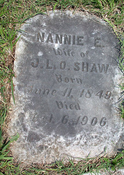
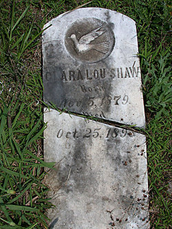
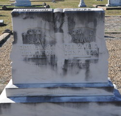
Nannie Elizabeth Smith Shaw
| Birth | : | 11 Jun 1849 USA |
| Death | : | 6 Oct 1906 USA |
| Burial | : | St. Michael's Churchyard, Pitsea, Basildon District, England |
| Coordinate | : | 51.5620520, 0.5067230 |
frequently asked questions (FAQ):
-
Where is Nannie Elizabeth Smith Shaw's memorial?
Nannie Elizabeth Smith Shaw's memorial is located at: St. Michael's Churchyard, Pitsea, Basildon District, England.
-
When did Nannie Elizabeth Smith Shaw death?
Nannie Elizabeth Smith Shaw death on 6 Oct 1906 in USA
-
Where are the coordinates of the Nannie Elizabeth Smith Shaw's memorial?
Latitude: 51.5620520
Longitude: 0.5067230
Family Members:
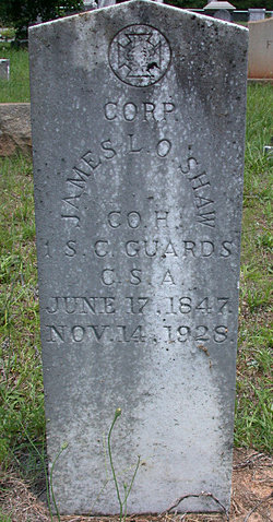
Spouse
Children
Flowers:


Nearby Cemetories:
1. St. Michael's Churchyard
Pitsea, Basildon District, England
Coordinate: 51.5620520, 0.5067230
2. Basildon Crematorium
Basildon, Basildon District, England
Coordinate: 51.5627300, 0.5235600
3. Pitsea Cemetery
Pitsea, Basildon District, England
Coordinate: 51.5641840, 0.5243510
4. St. Margaret of Antioch Churchyard
Pitsea, Basildon District, England
Coordinate: 51.5569160, 0.5309590
5. All Saints Churchyard
Vange, Basildon District, England
Coordinate: 51.5533240, 0.4723390
6. South Benfleet Cemetery
South Benfleet, Castle Point Borough, England
Coordinate: 51.5556220, 0.5501750
7. All Saints Churchyard
North Benfleet, Basildon District, England
Coordinate: 51.5813200, 0.5403260
8. St. Peter's Churchyard
Nevendon, Basildon District, England
Coordinate: 51.5885080, 0.5378120
9. St. Mary the Virgin Churchyard
South Benfleet, Castle Point Borough, England
Coordinate: 51.5461020, 0.5630390
10. St Michael Churchyard
Fobbing, Thurrock Unitary Authority, England
Coordinate: 51.5278690, 0.4752220
11. St Peter Churchyard
Thundersley, Castle Point Borough, England
Coordinate: 51.5687940, 0.5710100
12. Corringham Cemetery
Corringham, Thurrock Unitary Authority, England
Coordinate: 51.5268450, 0.4651920
13. Willow Cemetery
Canvey Island, Castle Point Borough, England
Coordinate: 51.5250060, 0.5440810
14. St. Mary the Virgin Churchyard
Corringham, Thurrock Unitary Authority, England
Coordinate: 51.5225460, 0.4631320
15. St Nicholas Churchyard
Laindon, Basildon District, England
Coordinate: 51.5792046, 0.4341750
16. St. Katherine Churchyard
Canvey Island, Castle Point Borough, England
Coordinate: 51.5207340, 0.5626850
17. St Mary Churchyard
Ramsden Crays, Basildon District, England
Coordinate: 51.6123140, 0.4656740
18. St Mary and All Saints Churchyard
Langdon Hills, Basildon District, England
Coordinate: 51.5511770, 0.4113210
19. St. Mary the Virgin Churchyard
Ramsden Bellhouse, Basildon District, England
Coordinate: 51.6210300, 0.4821470
20. St Mary Churchyard
Runwell, Chelmsford Borough, England
Coordinate: 51.6211190, 0.5318030
21. St Nicholas Churchyard
Rawreth, Rochford District, England
Coordinate: 51.6115180, 0.5702160
22. Great Burstead Cemetery
Great Burstead, Basildon District, England
Coordinate: 51.6030660, 0.4287890
23. St James the Less Churchyard
Hadleigh, Castle Point Borough, England
Coordinate: 51.5530400, 0.6095590
24. St. Mary Magdalene Churchyard
Great Burstead, Basildon District, England
Coordinate: 51.6039050, 0.4252480