

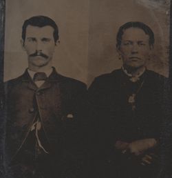
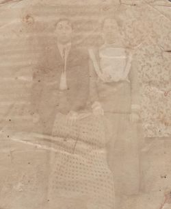
Nannie Ethel McCallister Owens
| Birth | : | 8 Jul 1891 Milton, Cabell County, West Virginia, USA |
| Death | : | 17 Feb 1994 USA |
| Burial | : | St. Michaels's Church Cemetery, Langley with Hardley, South Norfolk District, England |
| Coordinate | : | 52.5552220, 1.4727530 |
| Plot | : | Section Upper B |
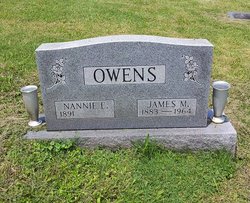
| Inscription | : | O W E N S NANNIE E. JAMES M. 1891 ____ 1883 - 1964 |
| Description | : | There is no date of death inscribed on this marker for Nannie. The dates listed are from the SSDI. West Virginia, Marriages Index, 1785-1971 Name: Nannie E McCallister Gender: Female Birth Date: abt 1892 Birth Place: Cabell County, West Virginia Age: 16 Spouse's Name: Jas M Owens Spouse Gender: Male Spouse Age: 25 Spouse Birth Place: Wood County, West Virginia Marriage Date: 17 May 1908 Marriage Place: Cabell County, West Virginia |
frequently asked questions (FAQ):
-
Where is Nannie Ethel McCallister Owens's memorial?
Nannie Ethel McCallister Owens's memorial is located at: St. Michaels's Church Cemetery, Langley with Hardley, South Norfolk District, England.
-
When did Nannie Ethel McCallister Owens death?
Nannie Ethel McCallister Owens death on 17 Feb 1994 in USA
-
Where are the coordinates of the Nannie Ethel McCallister Owens's memorial?
Latitude: 52.5552220
Longitude: 1.4727530
Family Members:
Parent

Spouse
Siblings
Children
Flowers:


Nearby Cemetories:
1. St. Michaels's Church Cemetery
Langley with Hardley, South Norfolk District, England
Coordinate: 52.5552220, 1.4727530
2. Hardley Methodist Chapel
Langley with Hardley, South Norfolk District, England
Coordinate: 52.5577290, 1.4957960
3. All Saints Churchyard
Chedgrave, South Norfolk District, England
Coordinate: 52.5409130, 1.4831200
4. St Peter's Churchyard
Carleton St Peter, South Norfolk District, England
Coordinate: 52.5680520, 1.4514100
5. Langley Abbey
Langley with Hardley, South Norfolk District, England
Coordinate: 52.5719000, 1.4875700
6. Holy Trinity Churchyard
Loddon, South Norfolk District, England
Coordinate: 52.5350430, 1.4832560
7. St Mary's Parish Churchyard
Ashby St Mary, South Norfolk District, England
Coordinate: 52.5679100, 1.4354760
8. St Margaret's Churchyard
Hardley Street, South Norfolk District, England
Coordinate: 52.5522980, 1.5170630
9. St Andrews
Claxton, South Norfolk District, England
Coordinate: 52.5769660, 1.4340060
10. St Gregory Churchyard
Heckingham, South Norfolk District, England
Coordinate: 52.5350940, 1.5144710
11. St. Margaret Churchyard
Cantley, Broadland District, England
Coordinate: 52.5826600, 1.5137200
12. St Peter's Churchyard
Mundham, South Norfolk District, England
Coordinate: 52.5303890, 1.4260120
13. St. Peter and St. Paul Churchyard
Bergh Apton, South Norfolk District, England
Coordinate: 52.5480290, 1.4060870
14. St Margaret and St Remigius Churchyard
Seething, South Norfolk District, England
Coordinate: 52.5303390, 1.4185000
15. St. John the Baptist Churchyard
Hellington, South Norfolk District, England
Coordinate: 52.5761440, 1.4132050
16. St. Mary's Churchyard
Hassingham, Broadland District, England
Coordinate: 52.5958770, 1.4963330
17. St. Nicholas' Churchyard
Buckenham, Broadland District, England
Coordinate: 52.5995590, 1.4770110
18. St. Botolph's Churchyard
Limpenhoe, Broadland District, England
Coordinate: 52.5811500, 1.5340800
19. St. Mary's Churchyard
Rockland St Mary, South Norfolk District, England
Coordinate: 52.5843940, 1.4112390
20. St Margaret Churchyard
Hales, South Norfolk District, England
Coordinate: 52.5109380, 1.5110840
21. St. Edmund's Church Cemetery
Southwood, Broadland District, England
Coordinate: 52.5918620, 1.5306067
22. St Edmund
Broadland District, England
Coordinate: 52.5930000, 1.5290000
23. Ss Mary and Margaret Churchyard
Norton Subcourse, North Norfolk District, England
Coordinate: 52.5324780, 1.5483860
24. St. Edmund's Churchyard
Broadland District, England
Coordinate: 52.5932110, 1.5299120