
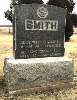
Nellie E. Conner Ritch
| Birth | : | 12 Apr 1871 Hinsdale, Berkshire County, Massachusetts, USA |
| Death | : | 13 Jul 1906 Glasco, Cloud County, Kansas, USA |
| Burial | : | Saint Marys Catholic Cemetery, Glasco, Cloud County, USA |
| Coordinate | : | 39.3574000, -97.8245000 |
| Description | : | Death date sent by DSH, #47399957 ******************** Glasco Sun, July 20, 1906, page 2: Obituary Nellie E. Conner was born at Hinsdale, Mass., April 12, 1871. She removed with her parents to Ottawa Co., Kansas, in August 1879, where she grew to womanhood. She was engaged for a number of years in the public schools of Cloud and adjoining counties. In 1898 she want to California, where she met and was married to James T. Ritch, Nov. 30th, 1899, at Bakersfield, Cal., to which union three children were born:- Eugene, aged 6; James, aged 4: and Aneita,... Read More |
frequently asked questions (FAQ):
-
Where is Nellie E. Conner Ritch's memorial?
Nellie E. Conner Ritch's memorial is located at: Saint Marys Catholic Cemetery, Glasco, Cloud County, USA.
-
When did Nellie E. Conner Ritch death?
Nellie E. Conner Ritch death on 13 Jul 1906 in Glasco, Cloud County, Kansas, USA
-
Where are the coordinates of the Nellie E. Conner Ritch's memorial?
Latitude: 39.3574000
Longitude: -97.8245000
Family Members:
Parent

Siblings
Flowers:


Nearby Cemetories:
1. Saint Marys Catholic Cemetery
Glasco, Cloud County, USA
Coordinate: 39.3574000, -97.8245000
2. Glasco Cemetery
Glasco, Cloud County, USA
Coordinate: 39.3574000, -97.8265000
3. Bethel Cemetery
Meredith Township, Cloud County, USA
Coordinate: 39.3506000, -97.7029000
4. Simpson Cemetery
Simpson, Mitchell County, USA
Coordinate: 39.3633003, -97.9471970
5. Delphos Cemetery
Delphos, Ottawa County, USA
Coordinate: 39.2778015, -97.7416992
6. Saint Paul Cemetery
Delphos, Ottawa County, USA
Coordinate: 39.2677994, -97.7518997
7. Morrison Cemetery
Center Township, Cloud County, USA
Coordinate: 39.4817009, -97.7975006
8. Asherville Cemetery
Asherville, Mitchell County, USA
Coordinate: 39.4205000, -97.9672900
9. Summit Cemetery
Jamestown, Cloud County, USA
Coordinate: 39.4813200, -97.8628800
10. Hall Cemetery
Cloud County, USA
Coordinate: 39.4455986, -97.7033005
11. Green Mound Cemetery
Asherville, Mitchell County, USA
Coordinate: 39.3203011, -97.9858017
12. Coursen Grove Cemetery
Simpson, Mitchell County, USA
Coordinate: 39.3060989, -97.9792023
13. Saint Peters Cemetery
Miltonvale, Cloud County, USA
Coordinate: 39.3652350, -97.6483570
14. Bell-Bogardus Cemetery
Asherville, Mitchell County, USA
Coordinate: 39.4242410, -97.9919970
15. Bohemian National Cemetery
Ada, Ottawa County, USA
Coordinate: 39.2193870, -97.9054030
16. Wilcox Cemetery
Cloud County, USA
Coordinate: 39.4925003, -97.7313995
17. West Asher Cemetery
Scottsville, Mitchell County, USA
Coordinate: 39.4815000, -97.9661600
18. Baldwin Cemetery
Ottawa County, USA
Coordinate: 39.2061005, -97.9111023
19. Kindel Cemetery
Center Township, Cloud County, USA
Coordinate: 39.4519005, -97.6464005
20. Smith Cemetery
Asherville, Mitchell County, USA
Coordinate: 39.4516690, -98.0098850
21. Enterprise Cemetery
Cloud County, USA
Coordinate: 39.4230995, -97.6106033
22. McBride Cemetery
Beloit, Mitchell County, USA
Coordinate: 39.4808006, -97.9907990
23. Shiloh Cemetery
Beloit, Mitchell County, USA
Coordinate: 39.3574982, -98.0594025
24. Summit Cemetery #3
Macyville, Cloud County, USA
Coordinate: 39.5258330, -97.9194440