
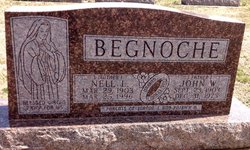
Nellie L “Nell” Breen Begnoche
| Birth | : | 29 Mar 1903 Meredith Township, Cloud County, Kansas, USA |
| Death | : | 25 Mar 1996 Salina, Saline County, Kansas, USA |
| Burial | : | Saint Joseph Cemetery, Saint Joseph, Cloud County, USA |
| Coordinate | : | 39.5074941, -97.4022328 |
| Plot | : | Site C/1 |
| Inscription | : | Mother Married Jun 23, 1925 Parents of Joanne T and Patrick H |
| Description | : | Salina Journal – Mar. 27, 1996 Nell Begnoche CLYDE — Nell Begnoche, 92, formerly of Clyde, died Monday, March 25, 1996, at Smoky Hill Rehabilitation Center, Salina. Mrs. Begnoche was born Nell Breen on March 29, 1903, southeast of Concordia in Meredith Township. She was a homemaker and a member of St. John the Baptist Catholic Church, Clyde, Sts. Peter and Paul Catholic Church, Clay Center, and St. Ann's Society. She was preceded in death by her husband, John W., in 1975; an infant daughter; and a grandson. Survivors include a daughter, Joanne Koch of Salina; a son,... Read More |
frequently asked questions (FAQ):
-
Where is Nellie L “Nell” Breen Begnoche's memorial?
Nellie L “Nell” Breen Begnoche's memorial is located at: Saint Joseph Cemetery, Saint Joseph, Cloud County, USA.
-
When did Nellie L “Nell” Breen Begnoche death?
Nellie L “Nell” Breen Begnoche death on 25 Mar 1996 in Salina, Saline County, Kansas, USA
-
Where are the coordinates of the Nellie L “Nell” Breen Begnoche's memorial?
Latitude: 39.5074941
Longitude: -97.4022328
Family Members:
Parent
Spouse

Siblings
Children
Flowers:


Nearby Cemetories:
1. Saint Joseph Cemetery
Saint Joseph, Cloud County, USA
Coordinate: 39.5074941, -97.4022328
2. Pleasant View Cemetery
Ames, Cloud County, USA
Coordinate: 39.5346985, -97.4431000
3. Cedar Grove Cemetery
Clyde, Cloud County, USA
Coordinate: 39.5494003, -97.4056015
4. Iwacura Cemetery
Morganville, Clay County, USA
Coordinate: 39.4550000, -97.3510000
5. French Presbyterian Church Cemetery
Cloud County, USA
Coordinate: 39.4395200, -97.4148290
6. Green Mound Cemetery
Rice, Cloud County, USA
Coordinate: 39.5248450, -97.5081630
7. Riverdale Cemetery
Clay County, USA
Coordinate: 39.5106010, -97.2930984
8. Mount Calvary Cemetery
Clyde, Cloud County, USA
Coordinate: 39.5917015, -97.4143982
9. Princeville Cemetery
Aurora, Cloud County, USA
Coordinate: 39.4672012, -97.5010986
10. Mount Hope Cemetery
Clyde, Cloud County, USA
Coordinate: 39.5969009, -97.4116974
11. Saint Peters Cemetery
Aurora, Cloud County, USA
Coordinate: 39.4763985, -97.5180969
12. Walnut Grove Cemetery
Cloud County, USA
Coordinate: 39.5699997, -97.4993973
13. Nelson Cemetery
Rice, Cloud County, USA
Coordinate: 39.5257988, -97.5410995
14. Bloom Cemetery
Morganville, Clay County, USA
Coordinate: 39.4519005, -97.2778015
15. Lincoln Cemetery
Clay Center, Clay County, USA
Coordinate: 39.4230995, -97.2930984
16. Sulphur Springs Cemetery
Aurora, Cloud County, USA
Coordinate: 39.4086610, -97.4986840
17. Rice Cemetery
Rice, Cloud County, USA
Coordinate: 39.5614014, -97.5552979
18. Sherman Cemetery
Morganville, Clay County, USA
Coordinate: 39.5316300, -97.2243700
19. Smith Grave
Miltonvale, Cloud County, USA
Coordinate: 39.3645300, -97.4308700
20. Hollis Cemetery
Cloud County, USA
Coordinate: 39.6383018, -97.5361023
21. Norwegian Lutheran Cemetery
Clay Center, Clay County, USA
Coordinate: 39.5027900, -97.1828200
22. Agenda Cemetery
Agenda, Republic County, USA
Coordinate: 39.6761017, -97.4336014
23. Morganville City Cemetery
Morganville, Clay County, USA
Coordinate: 39.4733009, -97.1819000
24. Miltonvale Cemetery
Miltonvale, Cloud County, USA
Coordinate: 39.3358002, -97.4447021