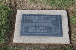
| Birth | : | 1882 Nebraska, USA |
| Death | : | 26 Sep 1963 Bakersfield, Kern County, California, USA |
| Burial | : | Greenlawn Cemetery and Mortuary, Bakersfield, Kern County, USA |
| Coordinate | : | 35.4067001, -118.9856033 |
| Description | : | Moon, Nellie Mae – Funeral services will be conducted at 1:30 p.m. Wednesday in the Memorial Chapel at Greenlawn Mortuary for Nellie Mae Moon, 84, 627 Beech St., who died Sept. 26 in a Bakersfield hospital. The Rev. O.B. Robertson, pastor of the First Southern Baptist Church, will officiate and interment will follow in the Garden of Roses at Greenlawn Memorial Park. Mrs. Moon was a native of Nebraska and had resided in California and Kern County 40 years. She is survived by a stepson, Clifford L. Moon of Bakersfield; two sisters, Florence Schmitt of Oregon and Vida Rollins of... Read More |
frequently asked questions (FAQ):
-
Where is Nellie Mae Cummins Moon's memorial?
Nellie Mae Cummins Moon's memorial is located at: Greenlawn Cemetery and Mortuary, Bakersfield, Kern County, USA.
-
When did Nellie Mae Cummins Moon death?
Nellie Mae Cummins Moon death on 26 Sep 1963 in Bakersfield, Kern County, California, USA
-
Where are the coordinates of the Nellie Mae Cummins Moon's memorial?
Latitude: 35.4067001
Longitude: -118.9856033
Family Members:
Parent
Spouse
Siblings
Children
Flowers:
Nearby Cemetories:
1. Greenlawn Cemetery and Mortuary
Bakersfield, Kern County, USA
Coordinate: 35.4067001, -118.9856033
2. Union Cemetery
Bakersfield, Kern County, USA
Coordinate: 35.3646500, -118.9948700
3. Home of Peace Jewish Cemetery
Bakersfield, Kern County, USA
Coordinate: 35.3631500, -118.9987400
4. Saint Pauls Episcopal Church Columbarium
Bakersfield, Kern County, USA
Coordinate: 35.3746120, -119.0277940
5. Kuntz Ranch Cemetery
Bakersfield, Kern County, USA
Coordinate: 35.4373560, -118.9390180
6. Chinese Cemetery
Bakersfield, Kern County, USA
Coordinate: 35.3510550, -119.0273380
7. Hillcrest Memorial Park
Bakersfield, Kern County, USA
Coordinate: 35.3814316, -118.9012527
8. Greenlawn Southwest Mortuary and Cemetery
Bakersfield, Kern County, USA
Coordinate: 35.2948990, -119.0330810
9. Long Tom Mine Cemetery
Woody, Kern County, USA
Coordinate: 35.5495600, -118.8308700
10. Arvin Cemetery
Arvin, Kern County, USA
Coordinate: 35.2132300, -118.8952700
11. Shafter Memorial Park
Shafter, Kern County, USA
Coordinate: 35.4728012, -119.2341995
12. Engle Family Cemetery
Bakersfield, Kern County, USA
Coordinate: 35.6392060, -118.9231180
13. Pomfret Memorial Cemetery
Famoso, Kern County, USA
Coordinate: 35.6313580, -119.2064460
14. Bakersfield National Cemetery
Arvin, Kern County, USA
Coordinate: 35.2559600, -118.6693480
15. Weringer Cemetery
Woody, Kern County, USA
Coordinate: 35.7062100, -118.8320800
16. Blue Mountain Cemetery
Woody, Kern County, USA
Coordinate: 35.7065500, -118.8322400
17. Rankin Cemetery
Walker Basin, Kern County, USA
Coordinate: 35.3844560, -118.5388890
18. Fickert Family Cemetery
Bear Valley Springs, Kern County, USA
Coordinate: 35.1697260, -118.6443350
19. Wasco Memorial Park
Wasco, Kern County, USA
Coordinate: 35.6034740, -119.3845260
20. Cesar E. Chavez National Monument
Keene, Kern County, USA
Coordinate: 35.2236000, -118.5592400
21. Saint Joseph Cemetery
Havilah, Kern County, USA
Coordinate: 35.5147500, -118.5177700
22. Oak Grove Cemetery
Glennville, Kern County, USA
Coordinate: 35.7414017, -118.7157974
23. Williams Burial Site
Walker Basin, Kern County, USA
Coordinate: 35.4320950, -118.4815680
24. North Kern Cemetery
Delano, Kern County, USA
Coordinate: 35.7630560, -119.2580560


